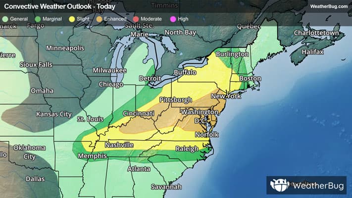
There is a Slight Severe Storm Risk for your location. Continue reading for today's outlook from the National Weather Service's Storm Prediction Center.
--------------------
National Severe Storm Outlook
THERE IS AN ENHANCED RISK OF SEVERE THUNDERSTORMS FROM PORTIONS OF THE NORTHEAST AND MID ATLANTIC TO THE OHIO VALLEY
SUMMARY
Numerous severe thunderstorms are expected across a broad region from the Tennessee and Ohio Valleys to the Mid-Atlantic and Northeast States into tonight. Swaths of damaging wind gusts are expected to be the most common impact, but some tornadoes and hail are possible as well.
20z Update Mid Atlantic and New England
A complicated convective situation continues across the area with numerous cluster of strong to severe storms ongoing from southern NY/CT/MA to the DelMarVA. A diffuse warm frontal zone from the Hudson valley to Long Island and the Atlantic coast has supported a few instances of stronger rotating supercells and QLCS structures. This focus may continue as additional more discrete storms approach from northern NJ and eastern PA. Otherwise, clustering of storms ahead of the cold front and across VA will pose a risk for damaging gusts through this evening. The primary update to the outlook was to lower probabilities behind the ongoing convection over NY and northeast OH where the air mass has been partially overturned. Isolated damaging gusts and some hail remain possible tonight.
OH Valley
A broken band of storms ahead of a cold front, extending into WV and southwest PA should continue to track east/southeast through this afternoon and into the evening hours. Strong northwesterly flow aloft is supporting moderate deep-layer shear and a mixed mode of supercells and clusters across southern IN/OH and into northern KY. A primary risk for damaging winds is expected given upscale growth as storm coverage increases. However, the large buoyancy (MLCAPE 3000-4000 J/kg) and some supercell structures could support large hail. Some tornado potential will also exist with the semi-discreet supercells and QLCS structures. This appears most likely near a convective modified boundary from astern OH into WV and southwest PA.
Storm coverage should continue to increase this afternoon across western KY and the lower OH Valley. With a predominately linear storm mode expected along the cold front, damaging winds are the most likely hazard. The primary change to the probabilities was to trim behind the front over OH/IN. See the prior outlook for more information.