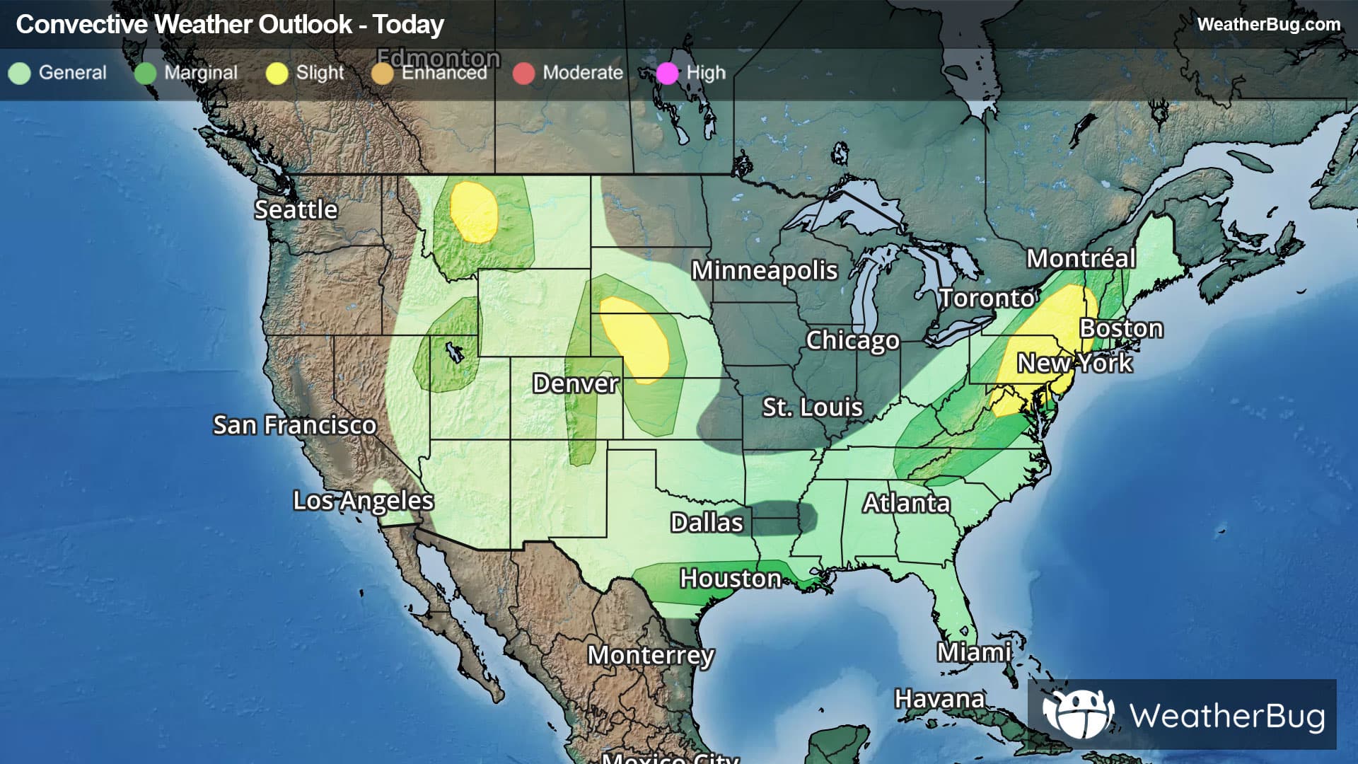
There is a Marginal Severe Storm Risk for your location. Continue reading for today's outlook from the National Weather Service's Storm Prediction Center.
--------------------
National Severe Storm Outlook
THERE IS A SLIGHT RISK OF SEVERE THUNDERSTORMS FOR PARTS OF WEST-CENTRAL NE INTO NORTHWEST KS...NORTHERN MID-ATLANTIC...AND WEST-CENTRAL MT
SUMMARY
Storms capable of producing severe hail and wind remain possible this evening across west-central Nebraska into northwest Kansas. Localized wind damage also remains possible over parts of the Mid-Atlantic and Northeast. Storms with localized severe gusts will continue through the evening across west-central Montana.
Central Plains
Earlier supercells have congealed into a small southward-moving cluster across northwest NE. Steep lapse rates, strong buoyancy (MLCAPE of 2000-3000 J/kg) and effective shear of 40-50 kt (as observed on the 00Z LBF sounding) within a northwesterly flow regime will continue to support organized storms through the evening. The severe-wind (potentially exceeding 75 mph) threat associated with this small MCS is expected to spread towards parts of southwest NE and northwest KS. Any embedded supercells or discrete cells along the periphery of the cluster will also remain capable of producing large hail, given the favorable thermodynamic environment and relatively elongated hodographs. Longevity of this cluster into late tonight is uncertain, due to increasing MLCINH and generally modest large-scale ascent. Some severe potential could spread as far as west-central/southwest KS before diminishing.
Parts of the Mid-Atlantic/Northeast
Scattered strong to locally severe storms are ongoing this evening from the northern Mid-Atlantic into parts of the Northeast. While substantial convective overturning has occurred, a corridor of moderate MLCAPE remains in place from northern VA into eastern PA and southeast NE. A short-term threat for locally damaging wind and perhaps marginal hail may continue before storms generally weaken by late evening. See MCD 2157 for more information.
West-central MT
High-based convection is ongoing early this evening across parts of west-central MT. Weak buoyancy will continue to hamper storm intensity, but the favorable lapse rate environment will continue to support potential for strong to severe gusts. See MCD 2158 for more information.
Parts of south-central TX
Scattered storms across south-central TX are ongoing near a southward-moving composite outflow. These storms may be capable of producing localized damaging gusts through dusk, before weakening with the onset of nocturnal cooling/stabilization.