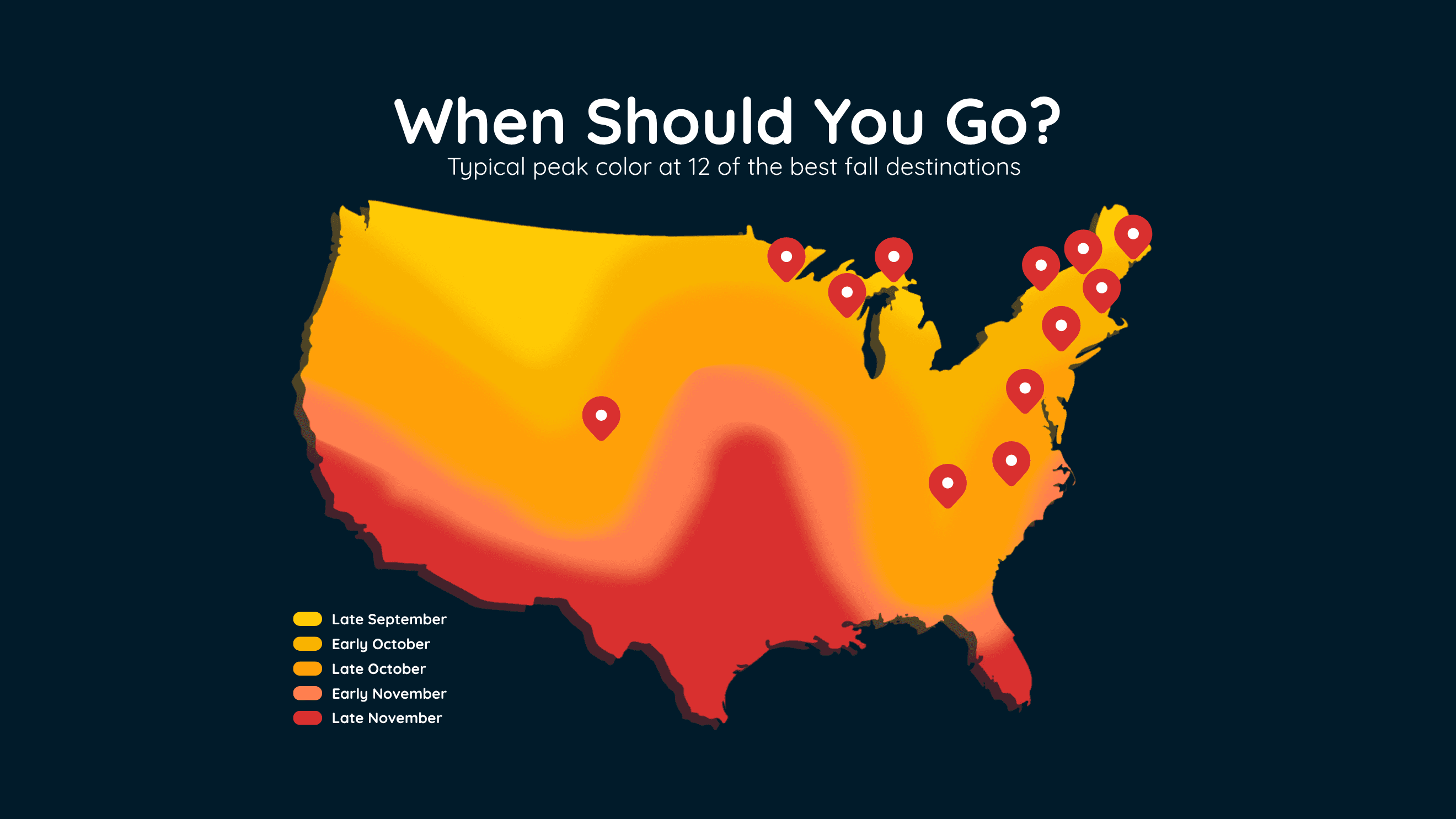
When Fall Colors Peak at 12 Top US Destinations
Find the best time to see peak fall colors at 12 popular U.S. destinations, including New England, the Smokies, Michigan and Colorado.
Read More
# HEADLINE -------------------- A SEVERE THUNDERSTORM WARNING REMAINS IN EFFECT UNTIL 745 PM CDT FOR FREMONT, MILLS AND SOUTHEASTERN CASS COUNTIES # SUMMARY -------------------- At 715 PM CDT, severe thunderstorms were located along a line extending from 2 miles south of Pacific Junction to 5 miles southwest of Tabor to 4 miles northeast of Nebraska City, moving east at 50 mph. # DETAILS -------------------- HAZARD 70 mph wind gusts. SOURCE Trained weather spotters reported winds up to 60 mph in northern Nebraska City at 710 PM. IMPACT Expect considerable tree damage. Damage is likely to mobile homes, roofs, and outbuildings. LOCATIONS IMPACTED INCLUDE - Plattsmouth, Glenwood, Shenandoah, Malvern, Sidney, Tabor, Farragut, Pacific Junction, Murray, Emerson, Riverton, Randolph, Hastings, Beaver Lake, Thurman, and Imogene. - This includes Interstate 29 between mile markers 10 and 32. ISSUED AT Monday, September 14, 2026 at 7:16 PM CDT ISSUED BY National Weather Service Omaha/Valley Nebraska HEADER Severe Weather Statement # PRECAUTIONARY/PREPAREDNESS ACTIONS -------------------- A Tornado Watch remains in effect until midnight CDT for southwestern Iowa...and southeastern Nebraska. For your protection move to an interior room on the lowest floor of a building. # AREAS AFFECTED -------------------- Cass NE, Fremont IA, Mills IA
# HEADLINE -------------------- FLOOD WATCH IN EFFECT FROM 6 PM CDT THIS EVENING THROUGH TUESDAY AFTERNOON # SUMMARY -------------------- .A conditional threat for heavy rain and flash flooding exists this evening into Tuesday morning. A line of thunderstorms is expected to move through the area with potential for at least 1 to 2 inch per hour rainfall rates and training thunderstorms. Areas that received recent heavy rainfall such as far southeast Nebraska will be more susceptible to flooding. # DETAILS -------------------- WHAT Flash flooding caused by excessive rainfall is possible. WHERE Portions of southwest Iowa, including the following counties, Fremont, Mills, Montgomery, Page and Pottawattamie and Nebraska, including the following counties, Cass, Douglas, Gage, Johnson, Lancaster, Nemaha, Otoe, Pawnee, Richardson and Sarpy. WHEN From 6 PM CDT this evening through Tuesday afternoon. IMPACTS Excessive runoff may result in flooding of rivers, creeks, streams, and other low-lying and flood-prone locations. ADDITIONAL DETAILS - Recent heavy rainfall combined with potential for repeated rounds of thunderstorms this evening and overnight will lead to a flash flooding threat through at least Tuesday morning. Additional rounds of rainfall will be possible through the remainder of the week. If confidence increases in potential for heavy rain Tuesday night into Wednesday, part or all of the watch may need to be extended. - For flood safety information, visit weather.gov/safety/flood. ISSUED AT Monday, September 14, 2026 at 11:24 AM CDT ISSUED BY National Weather Service Omaha/Valley NE HEADER URGENT - IMMEDIATE BROADCAST REQUESTED | Flood Watch # PRECAUTIONARY/PREPAREDNESS ACTIONS -------------------- You should monitor later forecasts and be prepared to take action should Flash Flood Warnings be issued. # AREAS AFFECTED -------------------- Cass, Douglas, Fremont, Gage, Johnson, Lancaster, Mills, Montgomery, Nemaha, Otoe, Page, Pawnee, Pottawattamie, Richardson, Sarpy Including the cities of Falls City, Farragut, Pawnee City, Red Oak, Beatrice, Shenandoah, Sidney, Nebraska City, Council Bluffs, Sterling, Clarinda, La Vista, Glenwood, Auburn, Papillion, Hamburg, Tecumseh, Table Rock, Lincoln, Omaha, Tabor, Bellevue, and Plattsmouth
# SUMMARY -------------------- THE NATIONAL WEATHER SERVICE HAS ISSUED TORNADO WATCH 669 IN EFFECT UNTIL MIDNIGHT CDT TONIGHT FOR THE FOLLOWING AREAS IN IOWA THIS WATCH INCLUDES 7 COUNTIES IN SOUTHWEST IOWA FREMONT HARRISON MILLS MONTGOMERY PAGE POTTAWATTAMIE SHELBY IN NEBRASKA THIS WATCH INCLUDES 16 COUNTIES IN EAST CENTRAL NEBRASKA BUTLER DODGE DOUGLAS SARPY SAUNDERS WASHINGTON IN SOUTHEAST NEBRASKA CASS GAGE JEFFERSON JOHNSON LANCASTER NEMAHA OTOE PAWNEE SALINE SEWARD THIS INCLUDES THE CITIES OF ASHLAND, AUBURN, BEATRICE, BELLEVUE, BLAIR, CLARINDA, COUNCIL BLUFFS, CRETE, DAVID CITY, DUNLAP, FAIRBURY, FARRAGUT, FREMONT, GLENWOOD, HAMBURG, HARLAN, LA VISTA, LINCOLN, LOGAN, MILFORD, MISSOURI VALLEY, NEBRASKA CITY, OMAHA, PAPILLION, PAWNEE CITY, PLATTSMOUTH, RED OAK, SEWARD, SHENANDOAH, SIDNEY, STERLING, TABLE ROCK, TABOR, TECUMSEH, WAHOO, WILBER, WOODBINE, AND YUTAN. # DETAILS -------------------- ISSUED AT Monday, September 14, 2026 at 4:51 PM CDT ISSUED BY NATIONAL WEATHER SERVICE OMAHA/VALLEY NE HEADER WATCH COUNTY NOTIFICATION FOR WATCH 669
Closest strike: 2.33 miles Stay Alert! Remain in a safe area until there has been no lightning within 10 miles of this location for 30 minutes. Please be aware that lightning activity can remain high even when a storm is moving away from your location. Even if rain has stopped, do not leave your safe area until WeatherBug indicates that lightning is more than 10 miles away from this selected location. IF OUTDOORS Avoid water, high ground, and open spaces. Avoid all metal objects including electric wires, fences, and machinery. Find a safe area in a building or in a fully enclosed vehicle with the windows completely shut. Unsafe places include underneath canopies, small picnic or rain shelters, convertibles, or near trees. IF INDOORS Avoid water and stay away from doors and windows. Avoid using a hard line telephone. Take off headphones. Turn off, unplug, and stay away from appliances, computers, power tools, and TV sets. Lightning may strike exterior electric and phone lines, inducing shocks to inside equipment.
There is a Slight Severe Storm Risk for your location. Continue reading for today's outlook from the National Weather Service's Storm Prediction Center. -------------------- National Severe Storm Outlook THERE IS A SLIGHT RISK OF SEVERE THUNDERSTORMS ACROSS NORTHERN KANSAS AND SOUTHERN/EASTERN NEBRASKA INTO WESTERN/CENTRAL IOWA SUMMARY Scattered strong to severe thunderstorms should occur across parts of eastern Nebraska into western/central Iowa this afternoon and evening. Large hail, severe wind gusts, and tornadoes all appear possible. Severe thunderstorm winds will also be possible across northern/western Kansas. 20z Update Visible satellite shows an expansive area of persistent mid-level cloud cover over much of Nebraska and adjacent regions of northwest Kansas and western Iowa. Some attempts at surface-based convection are apparent over portions of south-central Nebraska. Latest surface mesoanalysis shows destabilization is occurring across much of Kansas where skies are clear, with northward advancement now occurring into central/eastern Nebraska as evidenced by 2232 J/kg of MUCAPE in an 18z OAX observed sounding. This trend expected continue into the early evening, with rapid destabilization occurring across southeast Nebraska and southwest Iowa as the low-level jet shifts east and intensifies. An elongated area of convection is still expected to develop, from north-central Kansas into south-central/eastern Nebraska and west-central Iowa, favoring supercell modes early. Despite the noted convective/environmental trends, the exact placement of convective initiation remains uncertain, as exhibited in the most recent HRRR/RRFS runs. Additionally, most guidance continues to suggest a quick transition to mainly clusters/line segments. Therefore, no changes were made in this outlook.