Gusty Storms and Hail Hit Northern Plains, Rockies
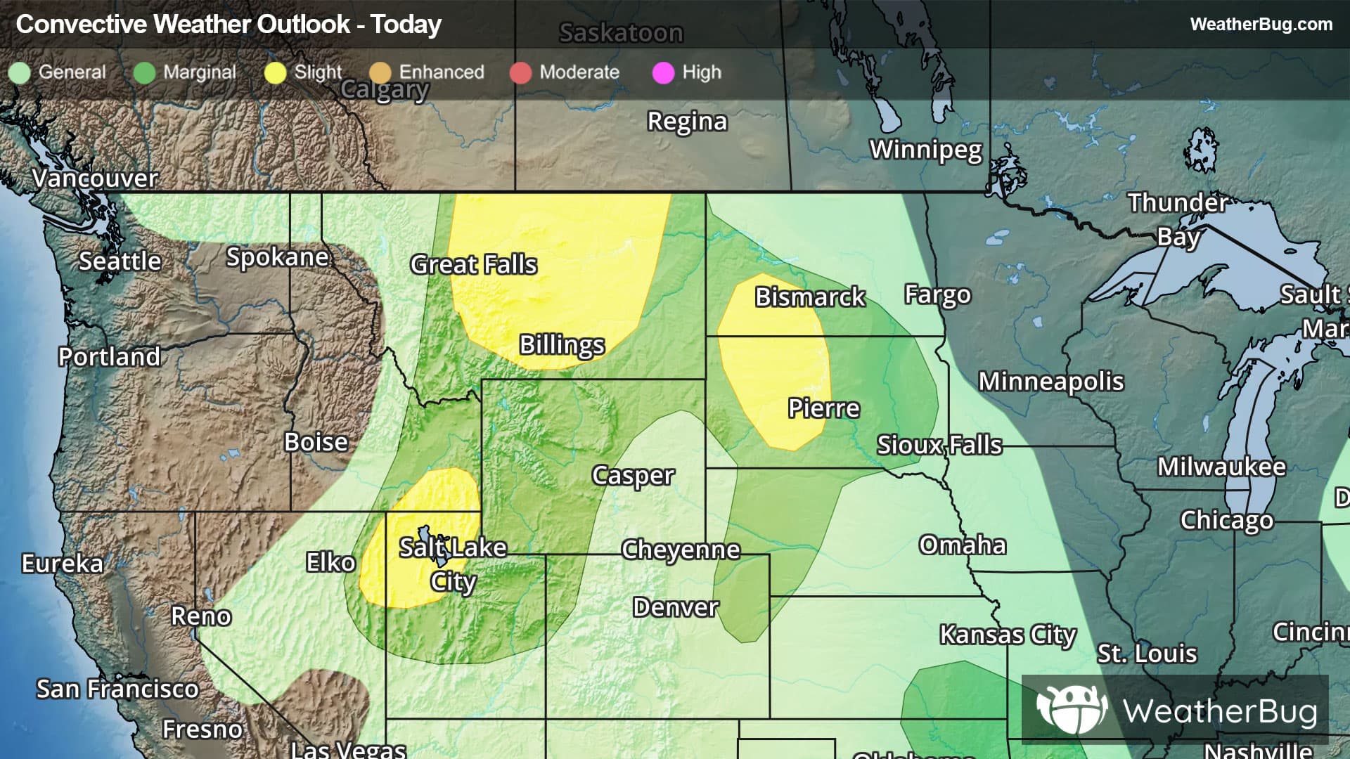
Several areas of severe weather for northern Plains and Rockies will occur today.
Read More
A Weather Alert has been issued for a nearby area. While your current location is outside of the impacted area, please stay alert and monitor weather conditions. # SUMMARY -------------------- The National Weather Service in Tucson has issued a - Severe Thunderstorm Warning for... South Central Pinal County in southeastern Arizona... - Until 800 PM MST. - At 718 PM MST, a severe thunderstorm was located 7 miles northeast of Picacho Peak State Park, moving northwest at 10 mph. # DETAILS -------------------- HAZARD 60 mph wind gusts and small hail. SOURCE Radar indicated. IMPACT Expect damage to roofs, siding, and trees. LOCATIONS IMPACTED INCLUDE Eloy, Picacho, Picacho Peak State Park, Red Rock and Cactus Forest. THIS INCLUDES THE FOLLOWING HIGHWAYS Route 79 between mile markers 104 and 128. Route 87 between mile markers 116 and 124. Interstate 10 between mile markers 205 and 230. ISSUED AT Sunday, August 23, 2026 at 7:18 PM MST ISSUED BY National Weather Service Tucson AZ HEADER BULLETIN - IMMEDIATE BROADCAST REQUESTED | Severe Thunderstorm Warning # PRECAUTIONARY/PREPAREDNESS ACTIONS -------------------- Seek shelter inside a well-built structure and stay away from windows. This storm is capable of producing damaging winds.
# HEADLINE -------------------- EXTREME HEAT WARNING REMAINS IN EFFECT UNTIL 8 PM MST SATURDAY # DETAILS -------------------- WHAT Dangerously hot conditions. Afternoon temperatures 105 to 116 expected. Major to Extreme Heat Risk. WHERE Aguila Valley, Apache Junction/Gold Canyon, Cave Creek/New River, Fountain Hills/East Mesa, Gila Bend, Northwest Pinal County, Sonoran Desert Natl Monument, Tonopah Desert, New River Mesa, Rio Verde/Salt River, and Superior. WHEN Until 8 PM MST Saturday. IMPACTS Heat related illnesses increase significantly during extreme heat events. Overexposure can cause heat cramps and heat exhaustion to develop and, without intervention, can lead to heat stroke. ADDITIONAL DETAILS In Maricopa County, call 2-1-1 to find a free cooling center, transportation, water and more. https://www.maricopa.gov/heat ISSUED AT Sunday, August 23, 2026 at 10:23 AM MST ISSUED BY National Weather Service Phoenix AZ HEADER URGENT - WEATHER MESSAGE # PRECAUTIONARY/PREPAREDNESS ACTIONS -------------------- An Extreme Heat Warning means that a period of very hot temperatures, even by local standards, will occur. Actions should be taken to lessen the impact of the extreme heat. Take extra precautions if you work or spend time outside. When possible, reschedule strenuous activities to early morning or evening. Know the signs and symptoms of heat exhaustion and heat stroke. Wear lightweight and loose-fitting clothing when possible and drink plenty of water. To reduce risk during outdoor work, the Occupational Safety and Health Administration recommends scheduling frequent rest breaks in shaded or air conditioned environments. Anyone overcome by heat should be moved to a cool and shaded location. Heat stroke is an emergency! Call 9 1 1. Public cooling shelters are available in some areas. Consult county officials for more details. # AREAS AFFECTED -------------------- Northwest Pinal County, Aguila Valley, Apache Junction/Gold Canyon, Cave Creek/New River, Fountain Hills/East Mesa, Gila Bend, New River Mesa, Rio Verde/Salt River, Sonoran Desert Natl Monument, Superior, Tonopah Desert, West Pinal County Including the cities of Gladden, Sentinel, Tonopah, Kaka, Wintersburg, Fountain Hills, Scottsdale, Superior, Tortilla Flat, Arlington, Hassayampa, Wickenburg, Aguila, Apache Junction, Coolidge, Casa Grande, Florence, Cactus Forest, and Gila Bend
Closest strike: 10.6 miles Storms Approaching Stay alert and frequently check WeatherBug to see if storms are moving toward you. Be mindful that new storms can also form with little notice.
There is a Marginal Severe Storm Risk for your location. Continue reading for today's outlook from the National Weather Service's Storm Prediction Center. -------------------- National Severe Storm Outlook THERE IS A SLIGHT RISK OF SEVERE THUNDERSTORMS ACROSS THE NORTHERN HIGH PLAINS AND GREAT BASIN SUMMARY Thunderstorms capable of large hail and severe-caliber wind gusts will continue this evening across eastern Montana and the western Dakotas, with other severe storms capable of wind gusts across the Great Basin. 01z Update Primary severe-weather corridor this evening will persist across east/northeast Montana to portions of the western Dakotas, but likely on a more marginal/isolated basis by the overnight. Other wind-producing storms will remain a possibility over the next couple of hours in areas such as northern Utah/far southeast Idaho, as well as southern Arizona. A couple of severe storms will remain a possibility this evening across northeast Ohio into northwest Pennsylvania. See Mesoscale Discussion 2108 for additional details. Later tonight, a modest increase in isentropic ascent associated with a south-southwesterly low-level jet may aid thunderstorm development late tonight and early Monday morning across parts of northeast Oklahoma and southeast Kansas to the Ozarks. Overall instability is expected to remain fairly weak (MUCAPE generally less than 1000 J/kg), but some clustering may occur with a low chance for localized severe wind gusts.