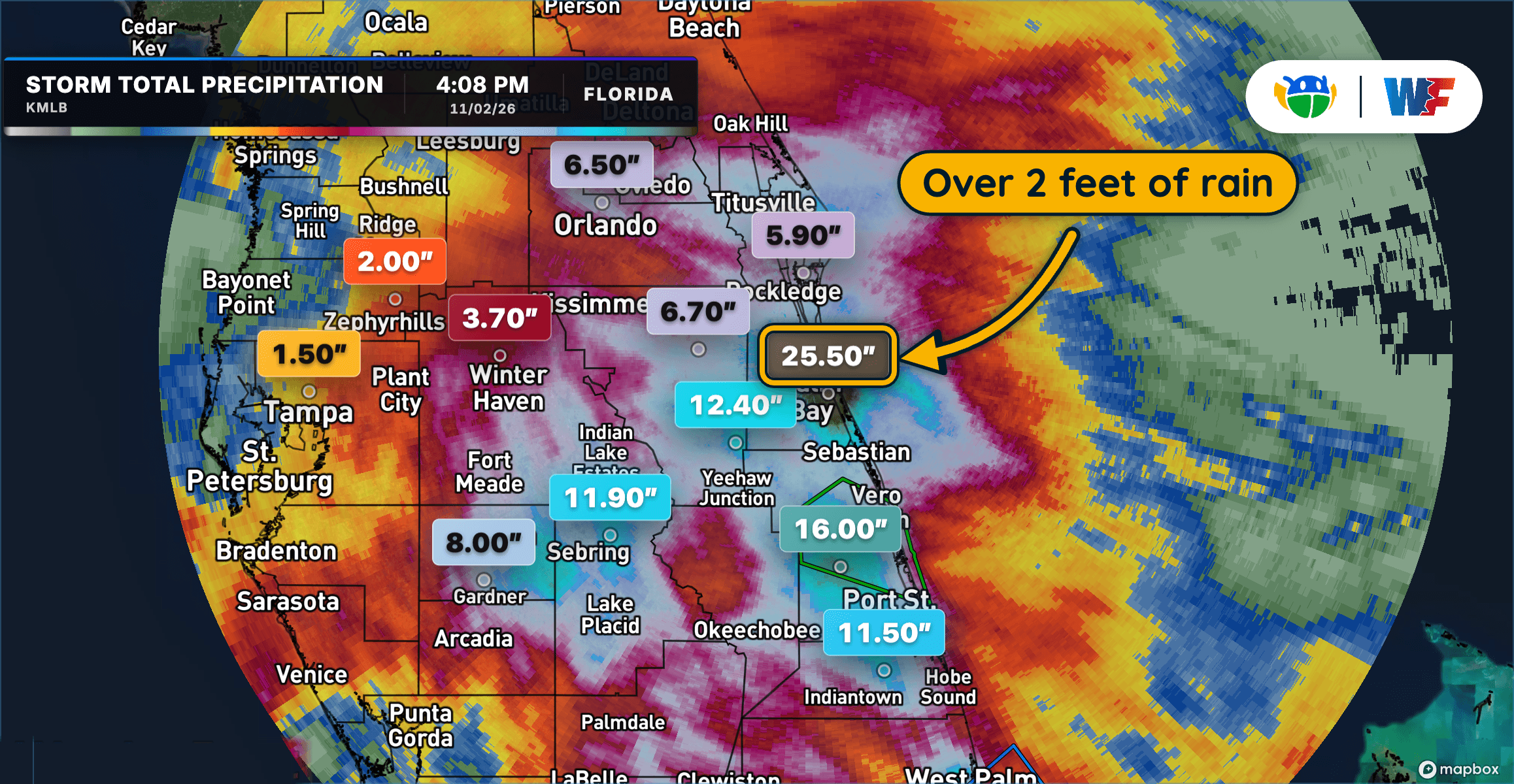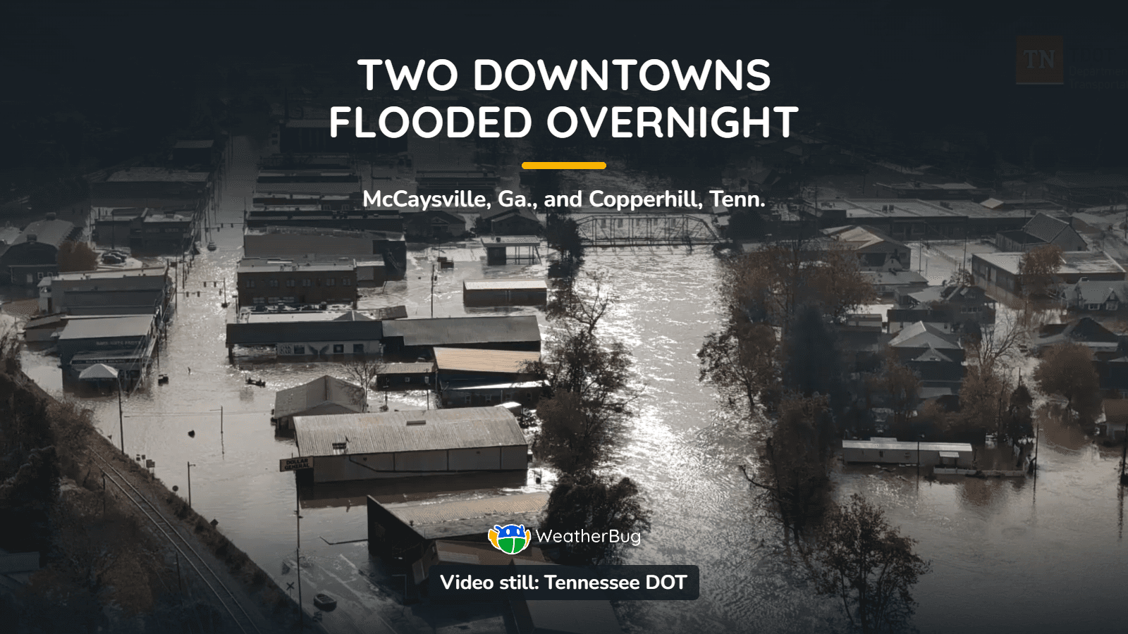
Record Flooding Hits Georgia–Tennessee Border After a Week of Floods Across the U.S.
After an already wet week in the south, another round of impressive rainfall causes rivers and streams to swell
Read More
# HEADLINE -------------------- FREEZE WARNING IN EFFECT FROM MIDNIGHT EST /11 PM CST/ SATURDAY NIGHT TO 10 AM EST /9 AM CST/ SUNDAY FROST ADVISORY REMAINS IN EFFECT UNTIL 9 AM EST /8 AM CST/ SATURDAY # DETAILS -------------------- WHAT For the Frost Advisory, temperatures as low as 33 will result in frost formation. For the Freeze Warning, sub-freezing temperatures as low as the upper 20s are expected. WHERE Portions of south central Indiana and east central, north central, northwest, and south central Kentucky. WHEN For the Frost Advisory, until 9 AM EST /8 AM CST/ Saturday. For the Freeze Warning, from midnight EST /11 PM CST/ Saturday Night to 10 AM EST /9 AM CST/ Sunday. IMPACTS Frost and freeze conditions could kill crops, other sensitive vegetation and possibly damage unprotected outdoor plumbing. Frost could harm sensitive outdoor vegetation. Sensitive outdoor plants may be killed if left uncovered. ISSUED AT Friday, November 6, 2026 at 11:56 PM EST ISSUED BY National Weather Service Louisville KY HEADER URGENT - WEATHER MESSAGE # PRECAUTIONARY/PREPAREDNESS ACTIONS -------------------- Take steps now to protect tender plants from the cold. To prevent water pipes from freezing; wrap or drain or allow them to drip slowly. # AREAS AFFECTED -------------------- Adair, Bourbon, Casey, Franklin, Grayson, Harrison IN, Larue, Allen, Anderson, Barren, Boyle, Breckinridge, Bullitt, Butler, Clark IN, Clark KY, Clinton, Crawford, Cumberland, Dubois, Edmonson, Fayette, Floyd, Garrard, Green, Hancock, Hardin, Harrison KY, Hart, Henry, Jefferson, Jefferson IN, Jessamine, Lincoln, Logan, Madison, Marion, Meade, Mercer, Metcalfe, Monroe, Nelson, Nicholas, Ohio, Oldham, Orange, Perry, Russell, Scott IN, Scott KY, Shelby, Simpson, Spencer, Taylor, Trimble, Warren, Washington IN, Washington KY, Woodford Including the cities of Springfield, Franklin, Jeffersonville, Hodgenville, Glasgow, Paoli, Bedford, Scottsville, Edmonton, Jamestown, Salem, Lewisport, Corydon, Bowling Green, Hardinsburg, Greensburg, Hawesville, Winchester, Harrodsburg, Cynthiana, Brownsville, Brandenburg, La Grange, Paris, Leitchfield, Georgetown, Scottsburg, Shepherdsville, English, Shelbyville, Lawrenceburg, Campbellsville, Stanford, New Albany, Versailles, Lexington, Tompkinsville, Richmond, Horse Cave, Albany, Bardstown, Elizabethtown, Carlisle, Hartford, New Castle, Lebanon, Danville, Burkesville, Russellville, Jasper, Frankfort, Columbia, Madison, Morgantown, Tell City, Taylorsville, Louisville, Nicholasville, Milton, Liberty, Providence, and Lancaster
# HEADLINE -------------------- FREEZE WARNING IN EFFECT FROM MIDNIGHT EST /11 PM CST/ SATURDAY NIGHT TO 10 AM EST /9 AM CST/ SUNDAY FROST ADVISORY REMAINS IN EFFECT UNTIL 9 AM EST /8 AM CST/ SATURDAY # DETAILS -------------------- WHAT For the Frost Advisory, temperatures as low as 33 will result in frost formation. For the Freeze Warning, sub-freezing temperatures as low as the upper 20s are expected. WHERE Portions of south central Indiana and east central, north central, northwest, and south central Kentucky. WHEN For the Frost Advisory, until 9 AM EST /8 AM CST/ Saturday. For the Freeze Warning, from midnight EST /11 PM CST/ Saturday Night to 10 AM EST /9 AM CST/ Sunday. IMPACTS Frost and freeze conditions could kill crops, other sensitive vegetation and possibly damage unprotected outdoor plumbing. Frost could harm sensitive outdoor vegetation. Sensitive outdoor plants may be killed if left uncovered. ISSUED AT Friday, November 6, 2026 at 11:56 PM EST ISSUED BY National Weather Service Louisville KY HEADER URGENT - WEATHER MESSAGE # PRECAUTIONARY/PREPAREDNESS ACTIONS -------------------- Take steps now to protect tender plants from the cold. To prevent water pipes from freezing; wrap or drain or allow them to drip slowly. # AREAS AFFECTED -------------------- Adair, Bourbon, Casey, Franklin, Grayson, Harrison IN, Larue, Allen, Anderson, Barren, Boyle, Breckinridge, Bullitt, Butler, Clark IN, Clark KY, Clinton, Crawford, Cumberland, Dubois, Edmonson, Fayette, Floyd, Garrard, Green, Hancock, Hardin, Harrison KY, Hart, Henry, Jefferson, Jefferson IN, Jessamine, Lincoln, Logan, Madison, Marion, Meade, Mercer, Metcalfe, Monroe, Nelson, Nicholas, Ohio, Oldham, Orange, Perry, Russell, Scott IN, Scott KY, Shelby, Simpson, Spencer, Taylor, Trimble, Warren, Washington IN, Washington KY, Woodford Including the cities of Springfield, Franklin, Jeffersonville, Hodgenville, Glasgow, Paoli, Bedford, Scottsville, Edmonton, Jamestown, Salem, Lewisport, Corydon, Bowling Green, Hardinsburg, Greensburg, Hawesville, Winchester, Harrodsburg, Cynthiana, Brownsville, Brandenburg, La Grange, Paris, Leitchfield, Georgetown, Scottsburg, Shepherdsville, English, Shelbyville, Lawrenceburg, Campbellsville, Stanford, New Albany, Versailles, Lexington, Tompkinsville, Richmond, Horse Cave, Albany, Bardstown, Elizabethtown, Carlisle, Hartford, New Castle, Lebanon, Danville, Burkesville, Russellville, Jasper, Frankfort, Columbia, Madison, Morgantown, Tell City, Taylorsville, Louisville, Nicholasville, Milton, Liberty, Providence, and Lancaster
After an already wet week in the south, another round of impressive rainfall causes rivers and streams to swell