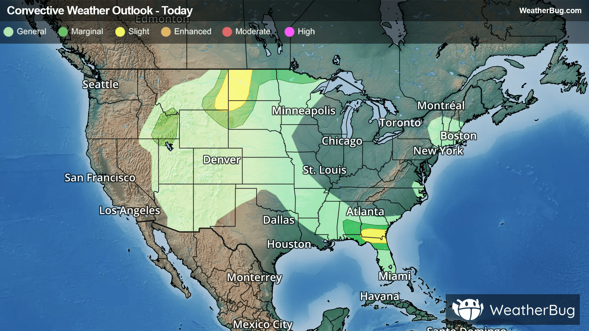
Weather Alerts
Severe Thunderstorm Watch
-# SUMMARY -------------------- SEVERE THUNDERSTORM WATCH 333 REMAINS IN EFFECT UNTIL 800 PM CDT FOR THE FOLLOWING LOCATIONS OH . OHIO COUNTIES INCLUDED ARE ADAMS ASHLAND ASHTABULA ATHENS BELMONT BROWN BUTLER CARROLL CHAMPAIGN CLARK CLERMONT CLINTON COLUMBIANA COSHOCTON CRAWFORD CUYAHOGA DELAWARE ERIE FAIRFIELD FAYETTE FRANKLIN GALLIA GEAUGA GREENE GUERNSEY HAMILTON HANCOCK HARRISON HIGHLAND HOCKING HOLMES HURON JACKSON JEFFERSON KNOX LAKE LICKING LORAIN LUCAS MADISON MAHONING MARION MEDINA MEIGS MONROE MONTGOMERY MORGAN MORROW MUSKINGUM NOBLE OTTAWA PERRY PICKAWAY PIKE PORTAGE RICHLAND ROSS SANDUSKY SCIOTO SENECA STARK SUMMIT TRUMBULL TUSCARAWAS UNION VINTON WARREN WASHINGTON WAYNE WOOD WYANDOT # DETAILS -------------------- ISSUED AT Sunday, June 14, 2026 at 2:33 PM CDT ISSUED BY NWS STORM PREDICTION CENTER NORMAN OK HEADER SEVERE THUNDERSTORM WATCH OUTLINE UPDATE FOR WS 333
Severe Thunderstorm Warning
-# SUMMARY -------------------- The National Weather Service in Wilmington has issued a - Severe Thunderstorm Warning for... Southeastern Champaign County in west central Ohio... Western Franklin County in central Ohio... Southwestern Delaware County in central Ohio... Northeastern Clark County in west central Ohio... Southern Union County in central Ohio... Madison County in central Ohio... - Until 415 PM EDT. - At 330 PM EDT, severe thunderstorms were located along a line extending from 7 miles northeast of Mechanicsburg to 6 miles east of Springfield, moving east at 40 mph. # DETAILS -------------------- HAZARD 60 mph wind gusts. SOURCE Radar indicated. IMPACT Expect damage to trees and power lines. LOCATIONS IMPACTED INCLUDE Columbus, Springfield, Dublin, Westerville, Grove City, Upper Arlington, Hilliard, Marysville, Worthington, London, Jefferson, Powell, Plain City, West Jefferson, Mechanicsburg, Minerva Park, Choctaw Lake, New California, Polaris, and Ohio State University. THIS INCLUDES THE FOLLOWING INTERSTATES I-70 in Ohio between mile markers 53 and 99. I-71 in Ohio near mile marker 106 and 123. ISSUED AT Sunday, June 14, 2026 at 3:31 PM EDT ISSUED BY National Weather Service Wilmington OH HEADER BULLETIN - IMMEDIATE BROADCAST REQUESTED | Severe Thunderstorm Warning # PRECAUTIONARY/PREPAREDNESS ACTIONS -------------------- For your protection move to an interior room on the lowest floor of a building. To report severe weather, go to our website at weather.gov/iln and submit your report via social media, when you can do so safely.
Special Weather Statement
-# HEADLINE -------------------- STRONG THUNDERSTORMS WILL IMPACT PORTIONS OF SOUTHEASTERN CHAMPAIGN COUNTY IN WEST CENTRAL OHIO, FRANKLIN AND SOUTHERN DELAWARE COUNTIES IN CENTRAL OHIO, NORTHERN CLARK COUNTY IN WEST CENTRAL OHIO, SOUTHERN UNION AND NORTHERN MADISON COUNTIES IN CENTRAL OHIO THROUGH 400 PM EDT # SUMMARY -------------------- At 319 PM EDT, strong thunderstorms were located along a line extending from Marysville to near Springfield, moving east at 45 mph. # DETAILS -------------------- HAZARD Wind gusts up to 50 mph and very heavy rain. SOURCE Radar indicated. IMPACT Gusty winds could knock down tree limbs and blow around unsecured objects. Visibility will be poor and hydroplaning is possible. LOCATIONS IMPACTED INCLUDE Columbus, Springfield, Dublin, Westerville, Reynoldsburg, Grove City, Upper Arlington, Gahanna, Hilliard, Marysville, Worthington, Bexley, London, Jefferson, Northridge, Powell, Canal Winchester, Groveport, Plain City, and West Jefferson. THIS INCLUDES THE FOLLOWING INTERSTATES - I-70 in Ohio between mile markers 60 and 111. I-71 in Ohio between mile markers 92 and 125. - If outdoors, consider seeking shelter inside a sturdy building. - Motorists should slow down and use extra caution. - A Severe Thunderstorm Watch remains in effect until 900 PM EDT for central and west central Ohio. - To report hazardous weather conditions, go to our website at weather.gov/iln and submit your report via social media, when you can do so safely. ISSUED AT Sunday, June 14, 2026 at 3:19 PM EDT ISSUED BY National Weather Service Wilmington OH HEADER Special Weather Statement # AREAS AFFECTED -------------------- Champaign OH, Clark OH, Delaware OH, Franklin OH, Madison OH, Union OH