Severe Thunderstorms Possible Across the Northern Plains
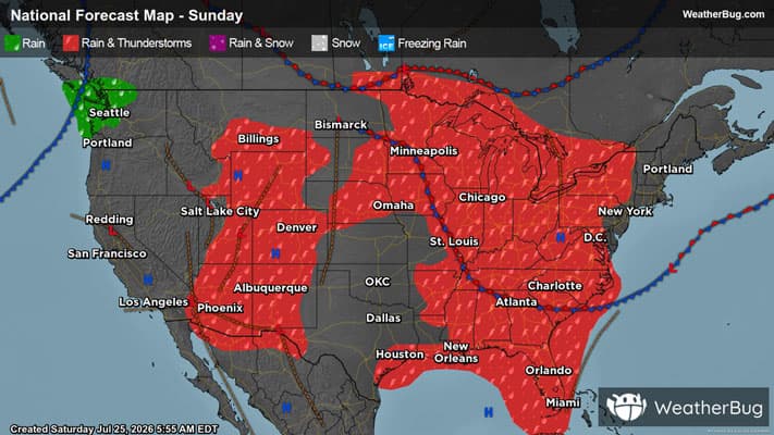
Severe weather may be found across the northern Plains this afternoon, with these storms slowly progressing east and reaching the East Coast by the early to middle part of next week.
Read More
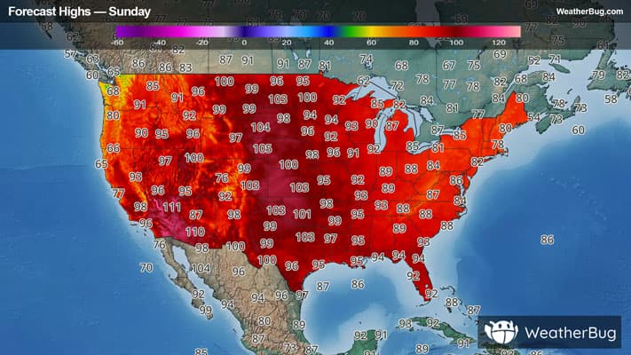
# HEADLINE -------------------- EXTREME HEAT WARNING REMAINS IN EFFECT FROM NOON TODAY TO 9 PM CDT THIS EVENING EXTREME HEAT WATCH REMAINS IN EFFECT FROM THIS EVENING THROUGH MONDAY EVENING # DETAILS -------------------- WHAT For the Extreme Heat Warning, dangerously hot conditions with heat index values near or exceeding 110 expected. For the Extreme Heat Watch, dangerously hot conditions with heat index values up to 110 possible. WHERE Portions of southern, central and east central Iowa. WHEN For the Extreme Heat Warning, from noon today to 9 PM CDT this evening. For the Extreme Heat Watch, from this evening through Monday evening. IMPACTS Heat related illnesses increase significantly during extreme heat and high humidity events. ISSUED AT Sunday, July 26, 2026 at 4:48 AM CDT ISSUED BY National Weather Service Des Moines IA HEADER URGENT - WEATHER MESSAGE # PRECAUTIONARY/PREPAREDNESS ACTIONS -------------------- Drink plenty of fluids, stay in an air-conditioned room, stay out of the sun, and check up on relatives and neighbors. # AREAS AFFECTED -------------------- Appanoose, Marion, Black Hawk, Bremer, Butler, Clarke, Davis, Decatur, Grundy, Jasper, Lucas, Mahaska, Marshall, Monroe, Poweshiek, Tama, Wapello, Wayne Including the cities of Humeston, Shell Rock, Seymour, Newton, Oskaloosa, Conrad, Chariton, Marshalltown, Dysart, Grinnell, Allison, Aplington, Cedar Falls, Lamoni, Knoxville, Greene, Grundy Center, Dumont, Toledo, Ottumwa, Wellsburg, Parkersburg, Allerton, Albia, Corydon, Bloomfield, Dike, Reinbeck, Centerville, Clarksville, Waverly, Traer, Osceola, Pella, Waterloo, Leon, Gladbrook, and Tama
# HEADLINE -------------------- EXTREME HEAT WARNING REMAINS IN EFFECT FROM NOON TODAY TO 9 PM CDT THIS EVENING EXTREME HEAT WATCH REMAINS IN EFFECT FROM THIS EVENING THROUGH MONDAY EVENING # DETAILS -------------------- WHAT For the Extreme Heat Warning, dangerously hot conditions with heat index values near or exceeding 110 expected. For the Extreme Heat Watch, dangerously hot conditions with heat index values up to 110 possible. WHERE Portions of southern, central and east central Iowa. WHEN For the Extreme Heat Warning, from noon today to 9 PM CDT this evening. For the Extreme Heat Watch, from this evening through Monday evening. IMPACTS Heat related illnesses increase significantly during extreme heat and high humidity events. ISSUED AT Sunday, July 26, 2026 at 4:48 AM CDT ISSUED BY National Weather Service Des Moines IA HEADER URGENT - WEATHER MESSAGE # PRECAUTIONARY/PREPAREDNESS ACTIONS -------------------- Drink plenty of fluids, stay in an air-conditioned room, stay out of the sun, and check up on relatives and neighbors. # AREAS AFFECTED -------------------- Appanoose, Marion, Black Hawk, Bremer, Butler, Clarke, Davis, Decatur, Grundy, Jasper, Lucas, Mahaska, Marshall, Monroe, Poweshiek, Tama, Wapello, Wayne Including the cities of Humeston, Shell Rock, Seymour, Newton, Oskaloosa, Conrad, Chariton, Marshalltown, Dysart, Grinnell, Allison, Aplington, Cedar Falls, Lamoni, Knoxville, Greene, Grundy Center, Dumont, Toledo, Ottumwa, Wellsburg, Parkersburg, Allerton, Albia, Corydon, Bloomfield, Dike, Reinbeck, Centerville, Clarksville, Waverly, Traer, Osceola, Pella, Waterloo, Leon, Gladbrook, and Tama
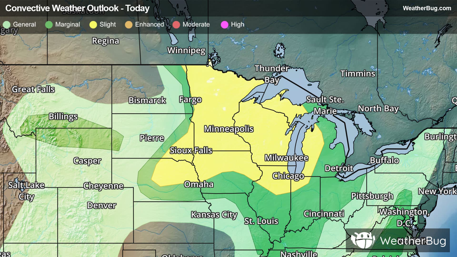
There is a Slight Severe Storm Risk for your location. Continue reading for today's outlook from the National Weather Service's Storm Prediction Center. -------------------- National Severe Storm Outlook THERE IS AN ENHANCED RISK OF SEVERE THUNDERSTORMS FOR EASTERN SD...SOUTHWEST MN...NORTHERN IA THERE IS A SLIGHT RISK OF SEVERE THUNDERSTORMS FOR PARTS OF CENTRAL/EASTERN MT SUMMARY Severe gusts (potentially greater than 75 mph) remain possible this evening from eastern South Dakota into northern Iowa and southwest Minnesota. Isolated to widely scattered severe gusts also remain possible across parts of Montana. SD into southern MN/northern IA/far northeast NE A loosely organized storm cluster is moving across eastern SD this evening. Additional intensification remains possible this evening, as this cluster encounters extreme downstream buoyancy, with MLCAPE of 4000-5000 J/kg within a very moist (dewpoints around 80 F) environment. The ongoing cluster has produced measured gusts of 60-80 mph, so any notable intensification could lead to an increase in potential for gusts in the 75-90 mph range. Isolated hail and perhaps a tornado also remain possible through dusk with this cluster. Increasing CINH with time and eastward extent should eventually result in a weakening trend later tonight, though an organized severe threat could eventually approach parts of southeast MN/northeast IA into northwest IL overnight. Farther northwest, a separate storm cluster is moving across north-central SD, within a similarly favorable environment. In the short term, this cluster may continue to move east-southeastward along a surface boundary with a continued severe-wind threat. Eventually, weakening buoyancy in the wake of the southeast SD cluster will tend to result in a weakening trend with this cluster. Central/eastern Montana Strong to locally severe storms may persist through dusk across parts of central/eastern MT, within a well-mixed environment that is favorable for severe-wind potential. Increasing CINH will result in an eventual weakening trend later tonight, though remnant outflows may still produce strong to locally severe gusts as storms diminish. Southern AZ Widely scattered storms and increasing outflow may continue to support strong to localized severe gusts within a very hot and well-mixed environment across parts of southern AZ. Weak deep-layer flow/shear should keep any remaining threat generally disorganized.