Northern Lights This Weekend: Will Clouds Block the View?
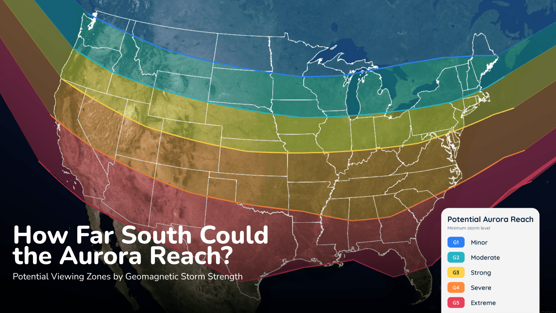
Aurora could reach parts of the northern United States Saturday night, but the cloud forecast may decide who actually sees it.
Read More
# HEADLINE -------------------- FLOOD WATCH REMAINS IN EFFECT FROM LATE TONIGHT THROUGH MONDAY AFTERNOON # DETAILS -------------------- WHAT Flooding caused by excessive rainfall continues to be possible. WHERE A portion of Utah, including the following areas, Western Millard and Juab Counties, Bear Lake and Bear River Valley, Cache Valley/Utah Portion, Eastern Box Elder County, Great Salt Lake Desert and Mountains, Northern Wasatch Front, Salt Lake Valley, Tooele and Rush Valleys, Utah Valley, Wasatch Back, Wasatch Mountains I-80 North, Wasatch Mountains South of I-80, Western Uinta Basin and Western Uinta Mountains. This includes recent burn scars such as Rocky Canyon. WHEN From late tonight through Monday afternoon. IMPACTS Excessive runoff may result in flooding of rivers, creeks, streams, and recent burn scars. Flooding may occur in poor drainage and urban areas. Extensive street flooding and flooding of creeks and rivers are possible. ADDITIONAL DETAILS - Moisture associated with the remnants of Tropical Storm Rachel will move into northern Utah this weekend producing a prolonged rainfall event. In particular, moisture interacting with a frontal boundary across far northern Utah may yield locally heavier rainfall totals compared to other locations. As a result, areal flooding is expected across northern Utah this weekend. - http://www.weather.gov/safety/flood ISSUED AT Saturday, October 10, 2026 at 4:07 AM MDT ISSUED BY National Weather Service Salt Lake City UT HEADER Flood Watch # PRECAUTIONARY/PREPAREDNESS ACTIONS -------------------- You should monitor later forecasts and be alert for possible Flood Warnings. Those living in areas prone to flooding should be prepared to take action should flooding develop. # AREAS AFFECTED -------------------- Eastern Box Elder County, Utah Valley, 80, 80 North, Bear Lake and Bear River Valley, Cache Valley/Utah Portion, Great Salt Lake Desert and Mountains, Northern Wasatch Front, Salt Lake Valley, Tooele and Rush Valleys, Wasatch Back, Wasatch Mountains I, Wasatch Mountains South of I, Western Millard and Juab Counties, Western Uinta Basin, Western Uinta Mountains Including the following locations - Little Sahara, Heber City, Snowville, Park City, Payson, Provo, Grantsville, Huntsville, Ogden, Roosevelt, Dugway, Brigham City, Woodruff, Sandy, Logan Summit, Mantua, Vernon, Brighton, Duchesne, West Jordan, Lehi, Mirror Lake Highway, Randolph, Delta, Wendover, Tooele, Park Valley, Salt Lake City, Smithfield, Logan, Moon Lake, Bountiful, Garden City, and Alta
# HEADLINE -------------------- WIND ADVISORY REMAINS IN EFFECT UNTIL 6 AM MDT SUNDAY # DETAILS -------------------- WHAT South winds 20 to 30 mph with gusts up to 50 mph. WHERE The Wasatch Front, Great Salt Lake Desert and Mountains, Tooele and Rush Valleys, Cache Valley/Utah Portion, Wasatch Back, Bear Lake and Bear River Valley, and Sanpete Valley. WHEN Until 6 AM MDT Sunday. IMPACTS Gusty winds will blow around unsecured objects and a few power outages may result. ISSUED AT Saturday, October 10, 2026 at 4:01 AM MDT ISSUED BY National Weather Service Salt Lake City UT HEADER URGENT - WEATHER MESSAGE # PRECAUTIONARY/PREPAREDNESS ACTIONS -------------------- Winds this strong can make driving difficult, especially for high profile vehicles and vehicles with trailers. Use extra caution. Secure outdoor objects. # AREAS AFFECTED -------------------- Eastern Box Elder County, Utah Valley, Bear Lake and Bear River Valley, Cache Valley/Utah Portion, Great Salt Lake Desert and Mountains, Northern Wasatch Front, Salt Lake Valley, Sanpete Valley, Tooele and Rush Valleys, Wasatch Back Including the following locations - Heber City, Snowville, Park City, Payson, Provo, Grantsville, Huntsville, Ogden, Dugway, Brigham City, Woodruff, Sandy, Vernon, West Jordan, Ephraim, Lehi, Mt Pleasant, Randolph, Wendover, Tooele, Park Valley, Salt Lake City, Smithfield, Logan, Bountiful, Garden City, and Manti
Closest strike: 3.25 miles Stay Alert! Remain in a safe area until there has been no lightning within 10 miles of this location for 30 minutes. Please be aware that lightning activity can remain high even when a storm is moving away from your location. Even if rain has stopped, do not leave your safe area until WeatherBug indicates that lightning is more than 10 miles away from this selected location. IF OUTDOORS Avoid water, high ground, and open spaces. Avoid all metal objects including electric wires, fences, and machinery. Find a safe area in a building or in a fully enclosed vehicle with the windows completely shut. Unsafe places include underneath canopies, small picnic or rain shelters, convertibles, or near trees. IF INDOORS Avoid water and stay away from doors and windows. Avoid using a hard line telephone. Take off headphones. Turn off, unplug, and stay away from appliances, computers, power tools, and TV sets. Lightning may strike exterior electric and phone lines, inducing shocks to inside equipment.
Aurora could reach parts of the northern United States Saturday night, but the cloud forecast may decide who actually sees it.