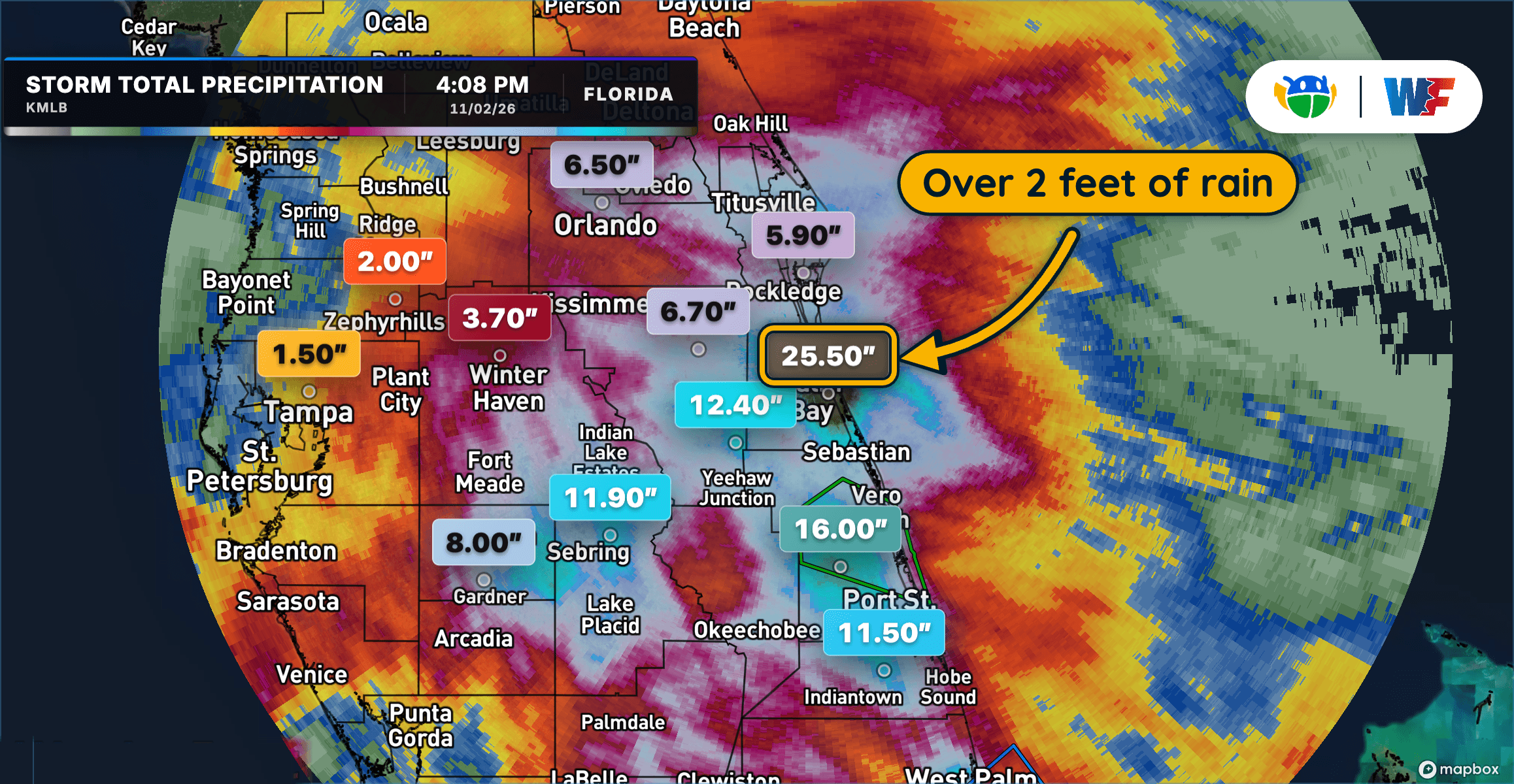
Extreme Rainfall Triggers Dangerous Flooding Across Central and East Florida
Extreme Rainfall Triggers Dangerous Flooding Across Central and East Florida
Read More
A Weather Alert has been issued for a nearby area. While your current location is outside of the impacted area, please stay alert and monitor weather conditions. # HEADLINE -------------------- A SEVERE THUNDERSTORM WARNING REMAINS IN EFFECT UNTIL 100 AM CST FOR NORTH CENTRAL PUSHMATAHA, SOUTH CENTRAL HASKELL, LATIMER AND WEST CENTRAL LE FLORE COUNTIES # SUMMARY -------------------- At 1232 AM CST, severe thunderstorms were located along a line extending from 4 miles southwest of Robbers Cave State Park to 3 miles southeast of Damon to near Clayton, moving northeast at 50 mph. # DETAILS -------------------- HAZARD 60 mph wind gusts. SOURCE Radar indicated. IMPACT Expect damage to roofs, siding, and trees. LOCATIONS IN OR NEAR THE PATH INCLUDE Wilburton... Clayton... Talihina... Red Oak... Albion... Higgins... Damon... Bengal... Tuskahoma... Yanush... Robbers Cave State Park... Stanley... Kiamichi... Gowen... Sardis... Panola... ISSUED AT Tuesday, November 3, 2026 at 12:33 AM CST ISSUED BY National Weather Service Tulsa OK HEADER Severe Weather Statement # PRECAUTIONARY/PREPAREDNESS ACTIONS -------------------- A Tornado Watch remains in effect until 300 AM CST for southeastern Oklahoma. For your protection move to an interior room on the lowest floor of a building. To report severe weather contact your nearest law enforcement agency. They will send your report to the National Weather Service office in Tulsa. # AREAS AFFECTED -------------------- Haskell OK, Latimer OK, Le Flore OK, Pushmataha OK
# SUMMARY -------------------- TORNADO WATCH 703 REMAINS VALID UNTIL 3 AM CST EARLY THIS MORNING FOR THE FOLLOWING AREAS IN ARKANSAS THIS WATCH INCLUDES 4 COUNTIES IN NORTHWEST ARKANSAS BENTON CRAWFORD WASHINGTON IN WEST CENTRAL ARKANSAS SEBASTIAN IN OKLAHOMA THIS WATCH INCLUDES 18 COUNTIES IN EAST CENTRAL OKLAHOMA CHEROKEE MUSKOGEE SEQUOYAH IN NORTHEAST OKLAHOMA ADAIR CRAIG DELAWARE MAYES NOWATA OTTAWA ROGERS WAGONER IN SOUTHEAST OKLAHOMA CHOCTAW HASKELL LATIMER LE FLORE MCINTOSH PITTSBURG PUSHMATAHA THIS INCLUDES THE CITIES OF ANTLERS, BENTONVILLE, CLAREMORE, CLAYTON, EUFAULA, FAYETTEVILLE, FORT SMITH, GROVE, HUGO, JAY, MCALESTER, MIAMI, MUSKOGEE, NOWATA, POTEAU, PRYOR, ROGERS, SALLISAW, SPRINGDALE, STIGLER, STILWELL, TAHLEQUAH, VAN BUREN, VINITA, WAGONER, AND WILBURTON. # DETAILS -------------------- ISSUED AT Tuesday, November 3, 2026 at 12:24 AM CST ISSUED BY NATIONAL WEATHER SERVICE TULSA OK HEADER WATCH COUNTY NOTIFICATION FOR WATCH 703
Closest strike: 11.21 miles Storms Approaching Stay alert and frequently check WeatherBug to see if storms are moving toward you. Be mindful that new storms can also form with little notice.
There is a Slight Severe Storm Risk for your location. Continue reading for today's outlook from the National Weather Service's Storm Prediction Center. -------------------- National Severe Storm Outlook THERE IS A SLIGHT RISK OF SEVERE THUNDERSTORMS ACROSS PARTS OF THE SOUTHERN AND CENTRAL PLAINS SUMMARY Severe thunderstorms with damaging wind gusts, hail, and a few tornadoes are expected across parts of the southern and central Plains this evening into tonight. Severe storms will also affect western Missouri and northwest Arkansas overnight. Southern and Central Plains/Lower to Mid Missouri Valley On water vapor imagery, an upper-level trough is evident in the southern High Plains with cyclonically curved southwest flow in place over the southern and central Plains. Within this flow, a 60 to 80 knot mid-level jet is analyzed from southern New Mexico extending northeastward into western Oklahoma. A line of strong to severe storms is ongoing to the east of the mid-level jet in an area with strong large-scale ascent from far southern Kansas into southwest Oklahoma. Ahead of this line, surface dewpoints are mostly in the lower to mid 60s F and the RAP has MLCAPE in the 1000 to 1500 J/kg range. In addition, the WSR-88D VWP at Oklahoma City has 0-6 km shear of 65 to 70 knots with some directional shear in the low-levels, and backing in the mid-levels. The strong deep-layer shear will continue to be favorable for severe storms this evening, as a line segment gradually organizes and moves eastward across the moist sector. So far across Oklahoma, the dominant storm mode has been linear, and discrete supercell development has failed to materialize. This will likely continue to be a problem this evening concerning the potential for a greater severe and tornado threat. Within the ongoing line, tornado potential will be maximized with embedded rotating elements. A few QLCS-type tornadoes still appear possible as this line moves eastward across central/northern Oklahoma and southeast Kansas this evening. A wind-damage threat will accompany the line, and a few gusts above 70 mph will be possible, mainly with the segments of the line that exhibit bowing structure...see MCD 2435 and 2437. The severe threat should impact western Missouri and northwest Arkansas during the overnight period. Further south into southwest Oklahoma and northwest Texas, the cells have been more discrete early this evening. A couple of supercells are ongoing near the Red River. These storms are located along the far southern edge of the low-level jet. As the low-level jet continues to ramp up this evening, low-level shear will be favorable for continued severe thunderstorm development. Severe wind gusts, hail and potentially a few tornadoes will be possible...see MCD 2436. West-central and North-central Texas The latest water vapor imagery shows a mid-level trough in the southern High Plains. The southeastern edge of the system is located across west-central Teas, where a band of strong thunderstorms is currently developing. These storms are located near a surface trough along the northwestern edge of a moist airmass with surface dewpoints in the mid to upper 60s F. Near the surface trough, the RAP has MLCAPE in the 2000 to 2500 J/kg range. In addition, the VAD wind profilers near San Angelo and Abilene have 40 to 50 knots of west-southwesterly flow in the mid-levels, which should support supercell development this evening. The primary threats are expected to be severe wind gusts and hail.
Extreme Rainfall Triggers Dangerous Flooding Across Central and East Florida