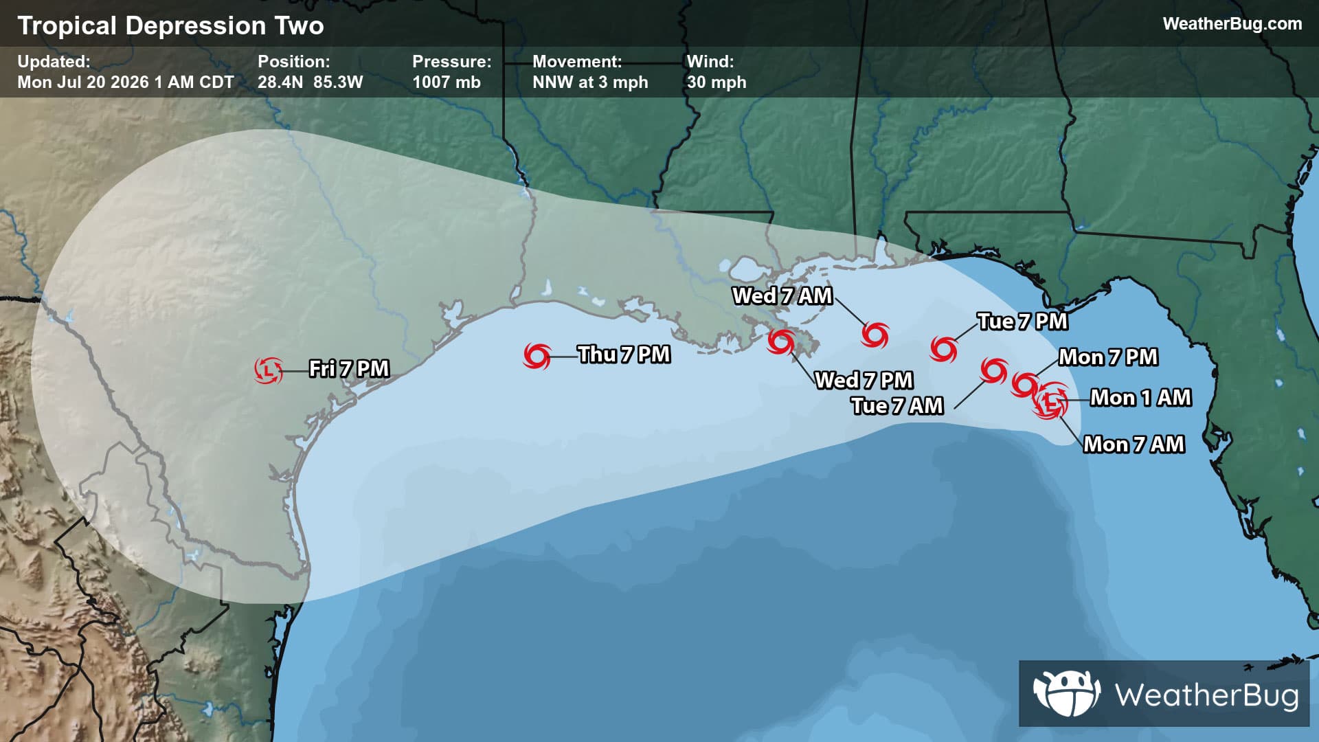
Weather Alerts For Wolf Run, OH
Frost Advisory
-# HEADLINE -------------------- FROST ADVISORY IN EFFECT FROM MIDNIGHT TONIGHT TO 8 AM EDT TUESDAY # DETAILS -------------------- WHAT Temperatures as low as 33 will result in frost formation. WHERE Portions of east central Ohio, southwest and western Pennsylvania, and northern and the northern panhandle of West Virginia. WHEN From midnight tonight to 8 AM EDT Tuesday. IMPACTS Frost could harm sensitive outdoor vegetation. Sensitive outdoor plants may be killed if left uncovered. ISSUED AT Monday, May 11, 2026 at 12:45 PM EDT ISSUED BY National Weather Service Pittsburgh PA HEADER URGENT - WEATHER MESSAGE # PRECAUTIONARY/PREPAREDNESS ACTIONS -------------------- Take steps now to protect tender plants from the cold. # AREAS AFFECTED -------------------- Beaver, Ohio, Preston, Allegheny, Brooke, Carroll, Columbiana, Coshocton, Eastern Preston, Fayette, Hancock, Harrison, Higher Elevations of Fayette, Higher Elevations of Westmoreland, Jefferson OH, Ridges of Eastern Monongalia and Northwestern Preston, Tuscarawas, Washington, Western Tucker, Westmoreland Including the cities of Hazelton, Kingwood, Murrysville, Hendricks, Bruceton Mills, Canonsburg, Salem, Ligonier, Uniontown, New Philadelphia, Coshocton, Saint George, Malvern, Beaver Falls, East Liverpool, Coopers Rock, Steubenville, Washington, Cadiz, Dover, Wellsburg, Wheeling, Carrollton, Greensburg, Follansbee, Terra Alta, Monessen, Latrobe, Champion, Lower Burrell, Monaca, New Kensington, Weirton, Ohiopyle, Parsons, Donegal, Pittsburgh Metro Area, Aliquippa, Columbiana, Ambridge, and Rowlesburg
Pollen Alert
-Pollen Index: 9.8 Pollen Level: high Predominant Pollen: Birch, Oak and Maple. The amount of pollen in the air for Tuesday will be falling but will remain in the high range. This forecast of lower pollen concentration is based on falling temperatures, higher dew points and lack of strong winds.