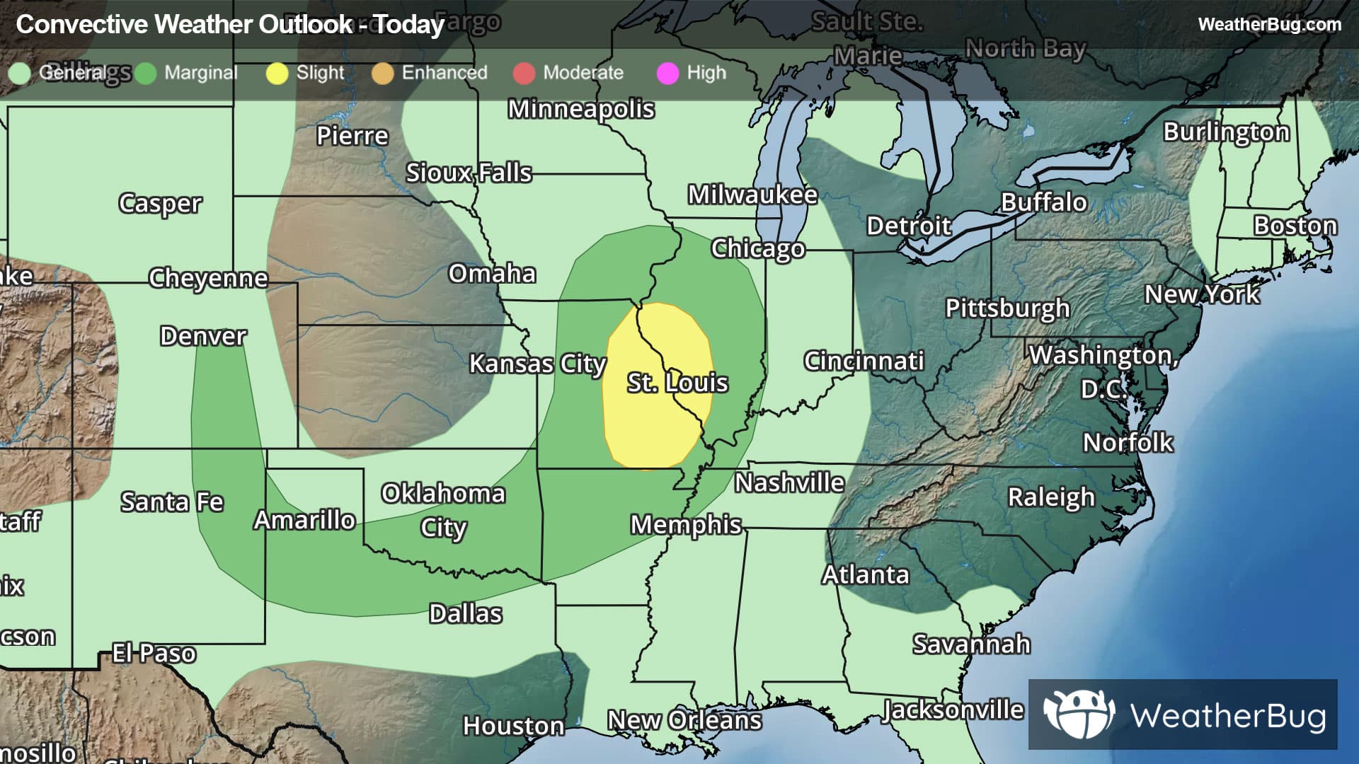
Weather Alerts
Special Weather Statement
-Special Weather Statement National Weather Service Wilmington OH 607 AM EDT Mon Mar 16 2026 Wayne-Fayette-Union-Franklin-Ripley-Dearborn-Ohio-Switzerland- Carroll-Gallatin-Boone-Kenton-Campbell-Owen-Grant-Pendleton- Bracken-Robertson-Mason-Lewis-Hardin-Mercer-Auglaize-Darke-Shelby- Logan-Delaware-Miami-Champaign-Clark-Madison-Licking-Preble- Montgomery-Greene-Pickaway-Fairfield-Butler-Warren-Clinton-Ross- Hocking-Hamilton-Clermont-Brown-Highland-Adams-Pike-Scioto- Including the cities of Richmond, Connersville, Liberty, West College Corner, Brookville, Batesville, Milan, Versailles, Osgood, Bright, Lawrenceburg, Hidden Valley, Greendale, Aurora, Dillsboro, Rising Sun, Vevay, Carrollton, Warsaw, Florence, Burlington, Oakbrook, Covington, Erlanger, Independence, Newport, Fort Thomas, Highland Heights, Bellevue, Dayton, Alexandria, Owenton, Williamstown, Crittenden, Dry Ridge, Falmouth, Butler, Augusta, Brooksville, Mount Olivet, Maysville, Tollesboro, Head Of Grassy, Camp Dix, Vanceburg, Kenton, Ada, Celina, Coldwater, Wapakoneta, St. Marys, New Bremen, Minster, Greenville, Sidney, Bellefontaine, Marysville, Delaware, Troy, Piqua, Tipp City, Urbana, Springfield, London, West Jefferson, Plain City, Downtown Columbus, Newark, Eaton, Camden, Downtown Dayton, Kettering, Beavercreek, Fairborn, Xenia, Washington Court House, Circleville, Lancaster, Pickerington, Hamilton, Middletown, Fairfield, Oxford, Mason, Lebanon, Landen, Springboro, Franklin, Wilmington, Blanchester, Chillicothe, Logan, Downtown Cincinnati, Milford, Summerside, Mount Carmel, Mount Repose, Withamsville, Mulberry, Day Heights, Georgetown, Mount Orab, Ripley, Aberdeen, Hillsboro, Greenfield, West Union, Manchester, Peebles, Seaman, Winchester, Waverly, Pike Lake, Piketon, Portsmouth, and Wheelersburg 607 AM EDT Mon Mar 16 2026 ...SNOW SHOWERS LIKELY TODAY INTO THIS EVENING... Scattered snow showers will become more widespread through this afternoon and then likely linger into this evening before tapering off. The snow showers will be capable of causing brief periods of reduced visibilities, especially this afternoon. In addition, brisk conditions will prevail with west winds gusting in the 30 to 40 mph range today. Light snow accumulations will be possible, mainly on grassy and elevated surfaces. While roads will remain mostly wet during the daytime hours, some slick spots may develop toward sunset as temperatures begin to drop below freezing. Please be prepared for the changing weather conditions today and the potential for reduced visibilities when driving.
Wind Advisory
-URGENT - WEATHER MESSAGE National Weather Service Wilmington OH 225 AM EDT Mon Mar 16 2026 Wayne-Fayette-Union-Franklin-Ripley-Dearborn-Ohio-Switzerland- Carroll-Gallatin-Boone-Kenton-Campbell-Owen-Grant-Pendleton- Bracken-Robertson-Mason-Hardin-Mercer-Auglaize-Darke-Shelby-Logan- Union-Delaware-Miami-Champaign-Clark-Madison-Franklin-Licking- Preble-Montgomery-Greene-Fayette-Pickaway-Fairfield-Butler-Warren- Clinton-Hamilton-Clermont-Brown-Highland- Including the cities of Minster, Xenia, Falmouth, Bellevue, Celina, Kenton, Landen, Wilmington, Springboro, Piqua, Osgood, Dayton, Highland Heights, Brooksville, Franklin, Warsaw, Owenton, Brookville, Bright, Urbana, Withamsville, Milan, Hillsboro, Richmond, Newark, Lebanon, Greenville, New Bremen, Carrollton, Tipp City, Downtown Dayton, Mount Carmel, Maysville, Fairfield, Oxford, Mason, Ada, Liberty, Connersville, Wapakoneta, Camden, Mount Repose, Butler, Batesville, Circleville, Dry Ridge, Fort Thomas, Erlanger, Crittenden, Pickerington, Alexandria, Downtown Columbus, Covington, Mount Olivet, Plain City, Versailles, Downtown Cincinnati, Mount Orab, St. Marys, Kettering, Day Heights, Georgetown, Mulberry, West College Corner, Vevay, London, Augusta, Lancaster, Greendale, Ripley, Greenfield, Marysville, Rising Sun, Springfield, Oakbrook, Coldwater, Aberdeen, Milford, West Jefferson, Beavercreek, Lawrenceburg, Summerside, Independence, Williamstown, Hamilton, Dillsboro, Burlington, Florence, Bellefontaine, Middletown, Troy, Washington Court House, Aurora, Delaware, Sidney, Blanchester, Fairborn, Hidden Valley, Eaton, and Newport 225 AM EDT Mon Mar 16 2026 ...WIND ADVISORY REMAINS IN EFFECT UNTIL 8 AM EDT THIS MORNING... * WHAT...Southwest winds 20 to 25 mph with gusts up to 45 mph. * WHERE...Portions of east central and southeast Indiana, northern Kentucky, and central, south central, southwest, and west central Ohio. * WHEN...Until 8 AM EDT this morning. * IMPACTS...Gusty winds will blow around unsecured objects. Tree limbs could be blown down and a few power outages may result. PRECAUTIONARY/PREPAREDNESS ACTIONS... Use extra caution when driving, especially if operating a high profile vehicle. Secure outdoor objects. &&
Severe Storm Risk
-There is a Marginal Severe Storm Risk for your location. Continue reading for today's outlook from the National Weather Service's Storm Prediction Center. -------------------- National Severe Storm Outlook THERE IS AN ENHANCED RISK OF SEVERE THUNDERSTORMS ACROSS PARTS OF THE LOWER OHIO VALLEY INTO MID SOUTH AND EASTERN GULF COAST STATES SUMMARY A squall line may continue to pose a risk for widespread strong to severe wind gusts and perhaps a couple of tornadoes through late evening as it progresses east of the middle Mississippi Valley into the Ohio Valley. The severe threat may continue into and through the overnight hours as it advances east of the lower Mississippi Valley toward the eastern Gulf Coast states. 01Z Update The northern flank of the ongoing squall line, and closely trailing cold front, just south of the center of the deep cyclone migrating toward Lower Michigan, is beginning to undercut a narrow pre-frontal plume of mid 50s F surface dew points advecting north-northeastward through the lower Ohio Valley. As this continues through the next few hours, it appears that inflow may become characterized by steadily decreasing CAPE, emanating from downstream a boundary layer with dew points still in the upper 40s F from Lexington and Louisville KY northward. While this is likely to result in weakening thunderstorm activity, it is possible that widespread gusts generally approaching to exceeding 50 kt may be a bit slower to diminish. Farther south, although an initial plume of better pre-frontal moisture return into the Mid South (characterized by lower 60s F dew points) may be overtaken by the squall line shortly, another plume of better boundary-layer moistening appears underway across eastern Mississippi and western Alabama. As this continues to develop northward this evening, beneath 40 kt southerly 850 mb flow, unstable inflow and strong shear may maintain or support re-intensification of storms across the Tennessee Valley into central and eastern Gulf States. Although model output has been varied, there remains at least some signal in potential for more discrete downstream supercell development within strengthening low-level warm advection late tonight across southeastern Alabama and adjacent portions of the Gulf Coast states. If this occurs, forecast low-level hodographs could support a strong tornado or two.