Central & Southern Plains Under Severe Threat
A low pressure system tracking across the central U.S. will continue to produce severe thunderstorms over the southern Plains today.
The weak area of low pressure over the northern Texas Panhandle, combined with leftover storm boundaries and daytime heating, will help fuel additional thunderstorms through tonight. A growing cluster of storms is already moving into western Oklahoma, where warm, humid air is helping them strengthen. Changing winds with height are also allowing storms to organize, with the potential for clusters to merge into one or two larger squall lines this evening.
Meanwhile, new storms developing across southwestern Kansas and the Texas Panhandle may expand and track southeast, possibly following earlier storms. While a brief tornado can’t be ruled out, the main threat will be strong, damaging wind gusts through the evening.
A Severe Thunderstorm Watch is in effect for portions of central and southern Oklahoma.
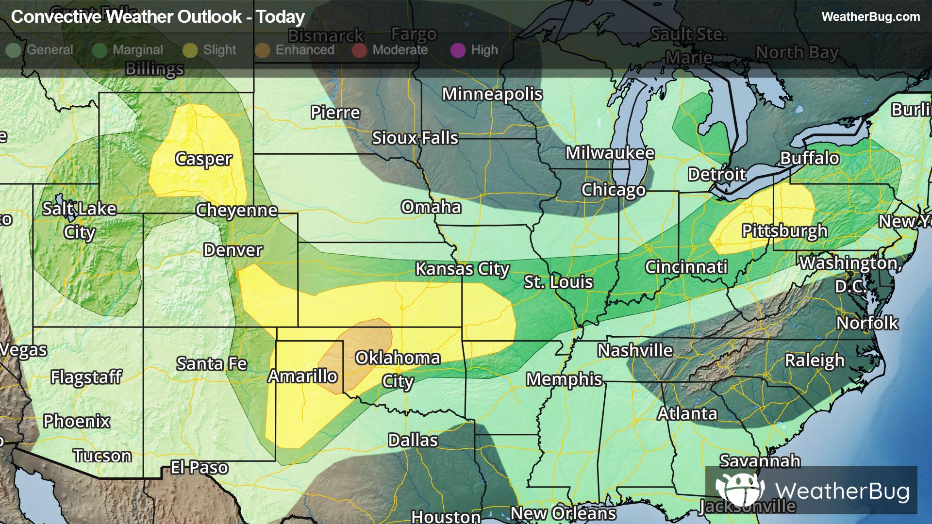
The Storm Prediction Center has issued an Enhanced Risk (Level 3 of 5) for parts of northwestern and west-central Oklahoma. Surrounding this area is a broader Slight Risk (Level 2 of 5) extending from the eastern Texas Panhandle through much of Oklahoma to south-central Kansas, northwest Arkansas, and southwest Missouri. Major cities within these risk areas include Amarillo and Lubbock, Tex., Oklahoma City and Tulsa, Okla., Wichita, Kan, and Springfield, Mo.
A separate Marginal Risk area is in effect today across central and southeastern Wyoming. Major cities within this risk area include Denver and Casper, Wyo. So far this evening, a line of thunderstorms with a strong outflow of cooler air is pushing southeast out of southeast Wyoming and into nearby parts of Nebraska and Colorado. As it moves along, some storms could produce occasional strong, damaging wind gusts.
Heavy rain and flooding will also be an issue with storms today. Flood Watches are currently in effect from the Central Plains and lower Mississippi Valley to parts of the Ohio Valley. As much as 2 to 4, locally 6 inches of rain is likely to fall over the next couple of days.
Make sure to know the difference between a watch and a warning should they be issued. A "watch" means that conditions are favorable for severe weather to occur, and to be on alert for any rapidly changing conditions. A "warning" means that severe weather is imminent, and you should act fast to remain safe.
The best way to remain safe is to stay prepared and informed about your local weather. Have a severe weather kit packed with a battery-operated radio, water, and non-perishable food items. Also, check the WeatherBug app frequently for any updates on today's severe weather. Remember, "When Thunder Roars, Go Indoors!"