
Dangerous Heat Wave to Build in Central U.S. Sunday, Expand East Through July 4th Week
Dangerous heat will build across the Plains and Midwest today. It will then expand to the East Coast through the upcoming week, bringing increasingly oppressive heat and humidity ahead of Independence Day.
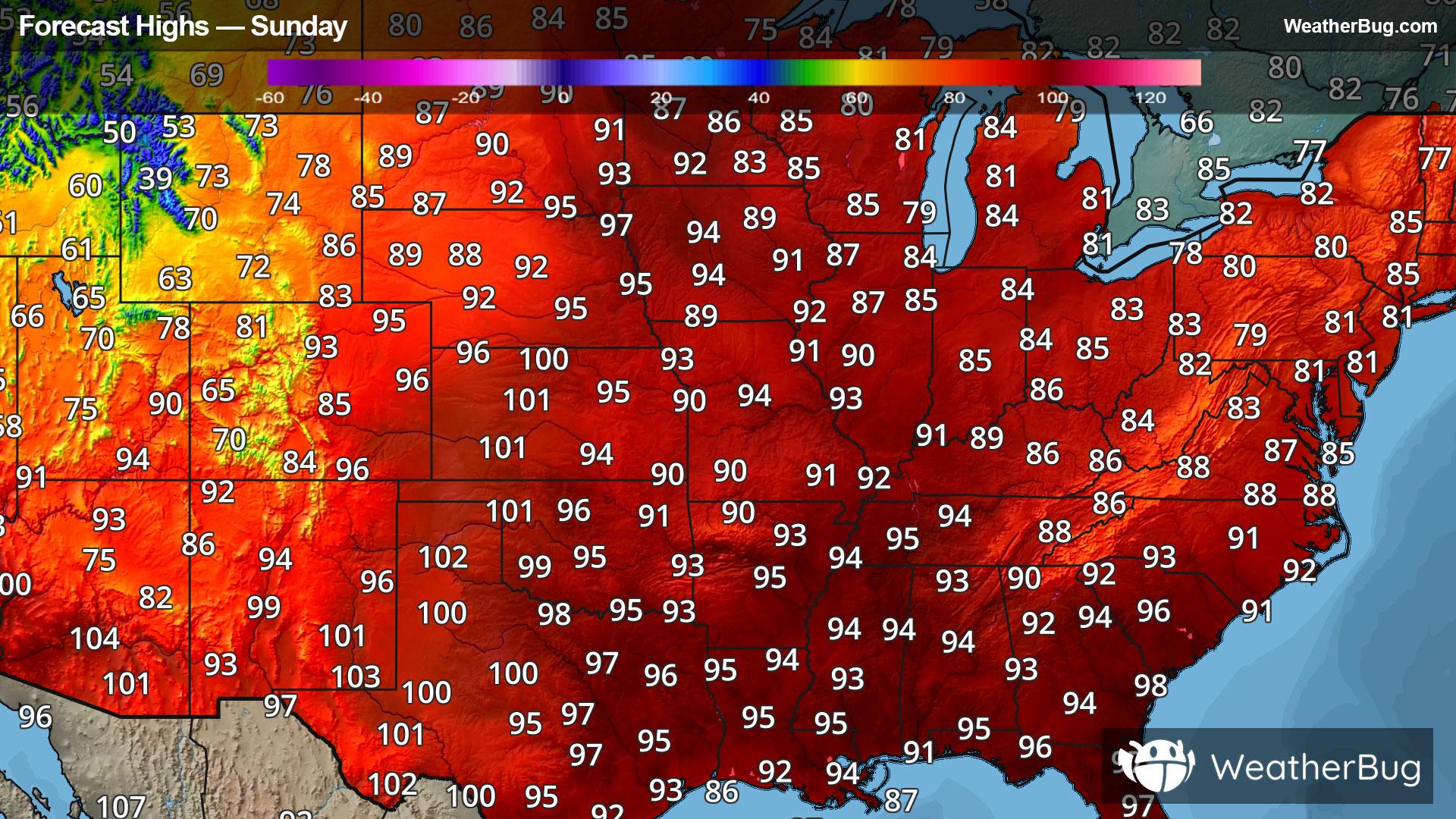
A strengthening upper-level ridge will build over the central United States Sunday, bringing summertime heat into full swing as temperatures across the Plains and Midwest climb into the low to mid 90s with heat index values pushing into the 100 to 110 degree range.
The heat will expand into the Great Lakes and Ohio Valley on Monday, with widespread 90s and heat index values climbing into the 100 to 105 degree range. Tuesday will feature similar conditions, with the core of the heat holding steady from the Midwest to central Mississippi Valley and Ohio Valley. The edge of the hotter, more humid air will also continue pushing east toward the Appalachians.
By Wednesday, the heat dome will become more firmly established as it reaches the East Coast, bringing a noticeable increase in both temperatures and humidity from the Southeast through the Mid-Atlantic and into the Northeast. This will mark a transition to a widespread and persistent stretch of heat across the eastern United States. The hottest period of the week is expected from Wednesday through Friday, when the ridge is fully anchored overhead. During this time, afternoon highs will climb into the upper 90s to lower 100s, and with the added humidity, it will feel more like 105 to 110 degrees, with a few locations briefly exceeding 110 degrees. Adding to the significant heat risk will be very limited nighttime relief, with overnight lows only falling into the upper 60s and 70s and remaining closer to 80 degrees in urban areas.
Heat-related alerts are already highlighting the dangerous nature of this event. Extreme Heat Warnings are in effect across parts of the Midwest where the most prolonged and dangerous conditions are expected first. Surrounding areas from the central Plains into the Tennessee Valley and Lower Mississippi Valley are under Heat Advisories. Farther north across parts of the northern Plains and Upper Midwest, Extreme Heat Watches have been issued. These alerts are expected to expand steadily eastward through midweek as the core of the heat shifts to the Southeast, Mid-Atlantic and Northeast.
Looking ahead to next weekend, the ridge is expected to weaken slightly but remain situated near the Mid-Atlantic Coast. This will keep temperatures on the hot side with continued humidity across the Eastern U.S. through the Independence Day holiday weekend.
If you are in one of these areas experiencing unseasonably hot temperatures, it will be important to stay hydrated and cool. Avoid exposure to the sun from late morning into the early evening. Take frequent breaks in the air conditioning or shade. Eat and dress lightly. Use sun protection if outdoors. Never leave kids or pets unattended and remember to “Look Before You Lock!” Recognize the signs of heat-related illness.