
Heavy Rain, Snow, and Winds Wallop Northwest
While the Pacific Northwest is still damp from the effect of last week's record-breaking atmospheric river, this week’s event will not let up on heavy rain, snowfall, and brisk winds.
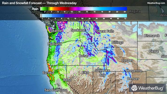
The first major squeeze of rain underneath the atmospheric river is ongoing in Washington and Oregon, bringing increasing impacts through early Wednesday morning. Overnight, a frontal system will push over the Northwest, bringing the heaviest rain and snow totals so far through this event. Snow levels will quickly lower behind its cold front, allowing for notable accumulation in the mid-elevations of the Northwest. A relative lull in rainfall is expected through the day on Wednesday, but impacts will be prevalent, especially across the ridges.
In the near term, rain totals through Wednesday morning are expected to commonly reach 1 to 2 inches along the coastline and the windward side of the Cascades. Upon the coastal range slopes and the Cascades, rain totals of 2 to 5 inches are expected.
Snow additions tonight into Wednesday will generally creep downslope, with deep accumulation toward the peaks. Two to 6 inches are expected in the northern Rocky mid-elevations and central Rockies as well as the mid to lower elevations of the Olympics and Cascades, with 6 to 12 inches along most of the Olympic and Cascade mid-to-high elevations and the peaks of the northern Rockies. Most ridges in the Pacific Northwest will push well over a foot of snow, with the most northerly peaks of the Cascades pushing over at least 2 feet!
Currently, Flood Watches are posted for portions of eastern and western Washington, northern Idaho, and far northwestern Montana. Winter Storm Warnings and Winter Weather Advisories are also posted for higher elevations of the Olympic Peninsula and Washington's Cascades. Winter Storm Watches are in effect for a portion of northwestern Montana and much of western Wyoming.
High winds are also expected to slam through the Northwest in the coming days, especially for the higher elevations, where some areas are expecting gusts of 50 to 65 mph or higher alongside 25 to 45 mph sustained winds at times!
Over a much greater area, High Wind Watches and Wind Advisories cover much of the coastal Pacific Northwest, the Cascades, the northern and central Rockies, the Rocky Front Range, and the northern Plains.
Although this atmospheric river is expected to be weaker than its predecessor, its impacts will still be widespread. River and flash flooding is possible through the day today, with major concerns for rockslides and mudslides from already saturated and unstable landscapes. Gusty winds could down trees and powerlines, and mountain passes along the Cascades will not be navigable at times in low visibility and winds gusts of 40 to 60 mph or greater. These conditions could pair with significant snow totals in the higher mountain passes, especially mid-week as snow levels drop in elevation.
As the week moves forward, another great push from the atmospheric river is expected on Thursday and Friday, with the greatest impacts in western Oregon and northern California. Snow levels are expected to rise again Thursday behind a warm front before dropping again on Friday behind yet another cold front.
Be sure to download the WeatherBug app to stay up to date on the latest on this changing weather. It’s never too early to have a supply kit packed in case of inclement weather. A simple kit including a weather radio, water, blankets, batteries, and non-perishable food items will go a long way in the event of a power outage.