Major Winter Storm Afflicts Midwest, Great Lakes
A burgeoning winter storm in the central Plains is on track to bring impactful snow or winds to the eastern two-thirds of the nation through Monday.
The latest storm system of many in the recent active weather pattern, a Canadian air mass and Gulf air mass, are being instigated by a deep reserve of upper-level energy to churn into a major storm system. As the storm churns northeastward through Monday, far-reaching snow will fall to its north and west, and high winds will encompass much of the central and eastern U.S. Its greatest wintry impacts will be felt across the Upper Midwest today and across the Great Lakes on Monday.
The storm’s intensifying cold front will also gather a sharp temperature decline that could turn lingering precipitation into very light to light snowfall as far south as Alabama on Monday!
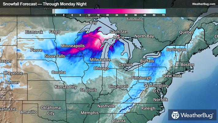
Through Monday night, snow totals of 1 to 2 feet or locally higher will pack into the eastern Rocky peaks as well as in northeastern Wisconsin and Michigan’s Upper Peninsula. Six to 12 inches are more likely for central Wisconsin, the high slopes of the Alleghenies, and just downwind of Lake Ontario. Lesser totals are possible across and near the rest of Appalachia and Midwest.
Blizzard Warnings are in effect from Iowa and southern Minnesota through Michigan's Upper Peninsula and northwestern Illinois. Winter Storm Warnings and Winter Weather Advisories have also been posted through southern Minnesota, northwestern Wisconsin, western Michigan, northern Missouri and northern Illinois. Some advisories extend up to western New York, New Hampshire, and Maine as well.
Widespread gusts of 45 to 60 mph or higher are also expected to travel ahead of, alongside, and behind the storm’s cold front. High-profile vehicles will be susceptible to tipping when crossing these high winds, which could pair with snowfall and low visibility to produce dangerous to impossible travel for most vehicles.
High Wind Watches, Wind Advisories, and High Wind Warnings cover a vast majority of the Midwest, and the Great Lakes region into northern and western New York. These impactful gusts will make driving difficult, especially for high-profile vehicles, and may lead to widespread power outages.
Red Flag Warnings have also been posted from western New Mexico through central and southern Mississippi. High winds and low humidity here could lead to rapidly deteriorating wildfire conditions.
Be sure to download the WeatherBug app to stay up to date on the latest on this changing weather. It’s never too early to have a supply kit packed in case of inclement weather. A simple kit including a weather radio, water, blankets, batteries, and non-perishable food items will go a long way in the event of a power outage. It’s always best to avoid traveling in rough weather as the roads will be dangerous.