


Hit-or-Miss Heavy Rain, Storms Led to Mixed Drought Results
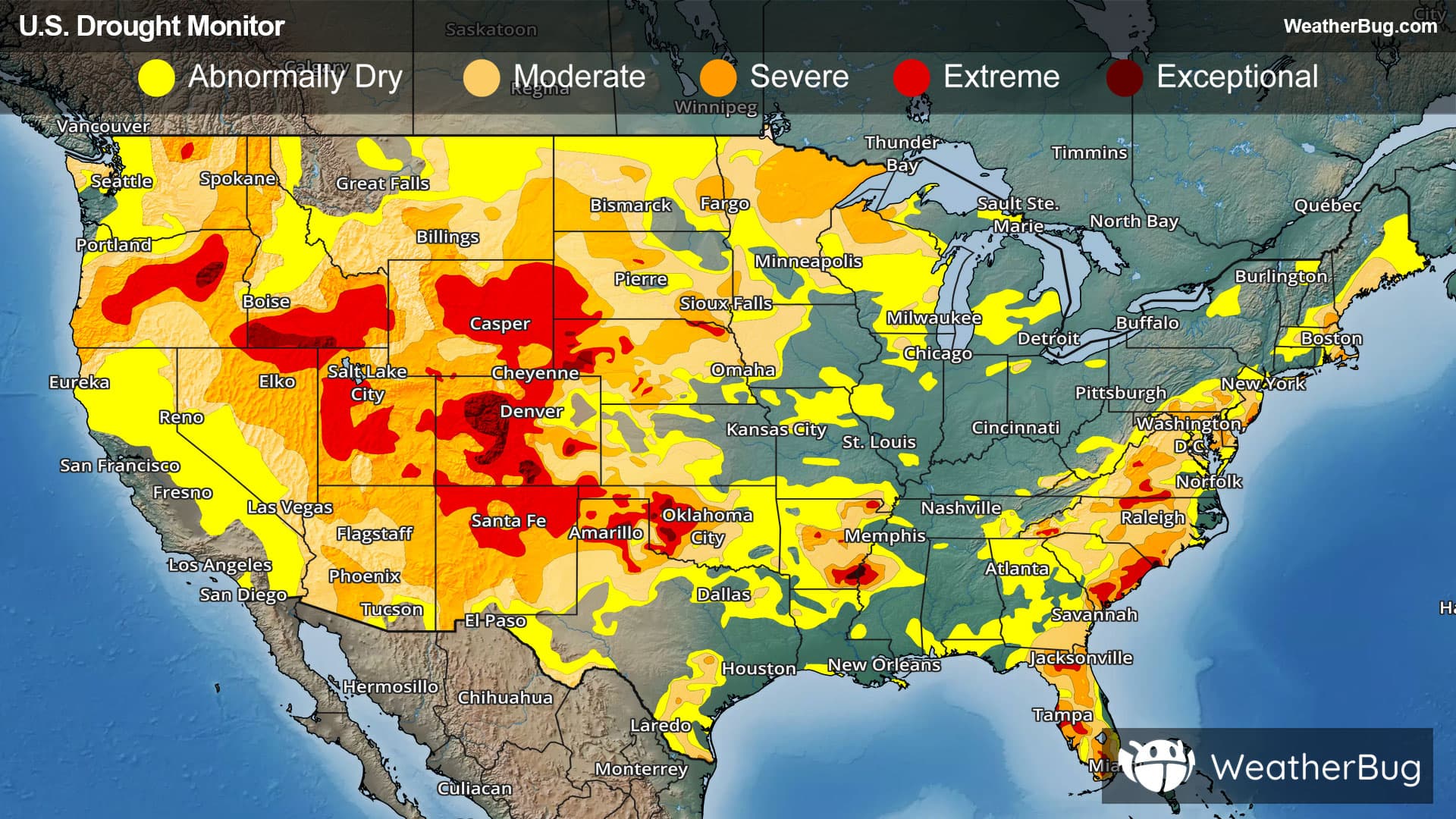
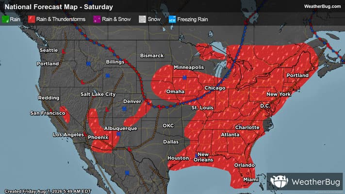
Summertime thunderstorms were found throughout much of the central and eastern U.S. However, these storms were overall hit-or-miss, so some locations saw moderate to heavy rain and drought improvements, while others stayed dry and drought conditions worsened. While dry weather prevailed throughout the West, hot and dry weather is common at this time of year, allowing for mainly limited deterioration to the drought depiction.
West
Monsoonal moisture flowing into an area dominated by high pressure led to mixed results to abnormally dry and drought conditions throughout the West. Temperatures also varied for the entire region. Near to below normal temperatures were restricted to the Pacific Northwest, central and northern California, and western Nevada, while the rest of the region reported unseasonably warm weather this week.
Areas of moderate to locally heavy rain were observed across patches from southeastern Arizona, the higher elevations of central Arizona, and southern Utah northward to southeastern Idaho, southern Montana, and eastern Montana. A few swatches received similar amounts in western Washington. This beneficial rainfall lead to improvements to the drought depiction. Most notably, areas of extreme drought (D3) were removed from eastern Arizona and south-central Montana, while extreme drought contracted across western New Mexico.
Other locations recorded little to no precipitation this week. However, dry and hot weather is not uncommon during the summer months across much of California and the Far West, so this did not impact abnormally dry and drought conditions substantially.
Despite ample winter precipitation, the lack of winter snowpack is starting to take its toll, with increasing moisture shortages leading to degradations across eastern Washington, northwestern and eastern Oregon, much of the Idaho Panhandle, and parts of eastern Montana. This includes the introduction of exceptional drought (D4) in eastern Oregon, with expansions of extreme drought (D3) across the rest of the state.
High Plains
Like the West, weather varied throughout the High Plains region last week. Monsoonal moisture combined with a stalled cold front brought beneficial moisture to some parts of the region, while hot and dry weather baked others. The dichotomy of conditions between eastern and western reaches of the region is reflected in the changes introduced in the Drought Monitor this week.
Heavy rains of 2 to 5 inches fell on northeastern South Dakota, a large part of northern and eastern Nebraska, and northeastern Kansas, with locally higher amounts. Moderate to heavy rain amounts were also observed elsewhere across the eastern and central sections of the Dakotas and Nebraska, southern and north-central and east-central Kansas, southeastern and the higher elevations farther west in Colorado, and patches of central and northern Wyoming into the western Dakotas.
Eastern South Dakota, central and eastern Nebraska, southeastern Colorado, and western Wyoming notched sizeable areas of improvement. Severe to exceptional drought (D2-D4) contracted in southeastern Wyoming, while severe to moderate drought (D3-D4) also decreased in size elsewhere.
In some of the drier parts of the region across North Dakota, central and western South Dakota, and western Nebraska, unusually hot weather accompanied relatively low rainfall amounts. At the same time, relative humidity has been unusually low. Many areas in eastern Wyoming, western South Dakota, and adjacent Nebraska reported 4-week relative humidity averaging among the driest 10% of historic observations for the time period, and a few spots were as dry as the lower 2% of historic observations. Less remarkable but still consistently below-normal relative humidity has prevailed over most of the region from the central Dakotas and Nebraska westward, along with most of Colorado.
Most of North Dakota, the western half of South Dakota, and parts of northeastern Wyoming, western Nebraska, and northeastern Colorado saw conditions deteriorate, as did southern Kansas adjacent to Oklahoma. A new patch of exceptional drought (D4) was brought into northwestern Nebraska and another introduced in parts of the Denver metro area. Existing areas of exceptional drought (D4) remained intact in the Nebraska Panhandle as well as east-central, south-central and interior western Colorado. A majority of Wyoming and Colorado also remain entrenched in extreme drought (D3), as do western reaches of Nebraska and South Dakota along with a few scattered locales farther south and east.
Midwest
An active weather pattern allowed for moderate to heavy rains to fall over much of the Midwest this week, with amounts of at least one-half inch falling on most locations.
Swaths of heavy to excessive rainfall (over 2 inches) were noted over sizeable areas in northwestern and southern Minnesota, southern and eastern Iowa, southern Wisconsin, much of northern Illinois, central Indiana, parts of western Ohio, and isolated locations across southern Kentucky, the Upper Peninsula of Michigan, and central through northern Missouri. For the most part, precipitation totals of up to 5 inches were observed in isolated spots across the aforementioned areas, but excessive amounts of 5 to 7 inches were more widespread in a band stretching across parts of southern Minnesota.
Due to the heavier rainfall, there were relatively broad areas of improvement to the drought depiction were seen in northwestern and southern Minnesota, far eastern Iowa, extreme southeastern Missouri, southern Wisconsin, northern Illinois, centra and northwestern Indiana, central Michigan, and southeastern Kentucky. The improvements were made to abnormal dryness and moderate to severe drought (D0-D2).
Conversely, heavier rains did miss some parts of the region. This combined with dryness over the previous few weeks caused dryness and drought to intensify. This includes northwestern Iowa, northern Wisconsin, southern Michigan, northern and southwestern Missouri, and northwestern Michigan. These locations recorded 10 to 50% of normal rain for the past 30 days. Abnormally dry and moderate drought (D0-D1) degraded across these spots.
South
Hit-or-miss showers and thunderstorms were seen throughout the South this week, leading to mixed results to abnormally dry and drought conditions. On top of that, hot and above normal temperatures dominated regionwide.
Moderate to heavy rain was fairly widespread across central and eastern Tennessee and the eastern half of Mississippi, although amounts exceeding 2 inches were mostly limited to north-central and southeastern Tennessee. Light rain (several tenths of an inch) with scattered higher totals were observed farther west across Arkansas and, to a lesser extent, Louisiana. Farther west, there were a few swaths of moderate to heavy rain in parts of northwestern Texas, eastern Oklahoma, and central to southwestern Texas, but most of these two states reported no measurable rain to a few tenths at best.
The dryness and heat have accelerated deterioration across Oklahoma and northern Texas, where many locations are seeing drying grass, depleted stream-fed and farm ponds, and increased fire danger. The past 30 days have brought less than half of normal rain to most locations from the Texas Panhandle and the Red River Valley northward, with the driest areas covering the central and eastern Texas Panhandle, western and northern Oklahoma, and some regions near the Red River.
Below-normal humidity at the same time also aggravated the situation in the Texas Panhandle and western Oklahoma. As a result, drought degradation was widespread across most of Oklahoma and northern Texas, indicative of rapid surface moisture loss. Other areas of deterioration included western Texas, Deep South Texas, western and northern Arkansas, and scattered parts of Louisiana and southern Mississippi. Most notably, both extreme and exceptional drought (D3-D4) expanded in the Texas and Oklahoma panhandles.
There were limited improvements made across the South this week. This includes small parts of southern Texas, northeastern Arkansas, and parts of eastern Tennessee. These improvements were made to abnormal dryness and moderate drought (D0-D1).
Southeast
The Southeast reported soggy, stormy weather throughout much of the week. Moderate to heavy rain fell on most of the region, especially from the central Florida Peninsula northward through most of the Florida Panhandle, south-central through east-central Georgia, and central South Carolina. Most locations reported over 2 inches of rain. Another fairly solid swath of similar amounts extended across central and south-central Virginia, in addition to some smaller patches across the region that included portions of the coastal Carolinas, the Piedmont and eastern slopes of the Appalachians across southern Virginia and the western Carolinas, and part of the southern Appalachians.
Excessive totals of 5 to locally 10 inches of rain drenched the northwestern Florida Peninsula and adjacent locations in the eastern Panhandle. There were also scattered locations that recorded over 5 inches of rain within the broader areas. These rains brought improvement to several swaths across the region. This includes northern and western Virginia, much of North Carolina, central South Carolina, eastern and southern Georgia, a small portion of northwestern Alabama, and most of Florida, where abnormal dryness and moderate to extreme drought (D0-D4) decreased in coverage. There were even a few small isolated spots that saw a 2-category improvement.
Despite the wet week, rainfall over the past 4 months is running anywhere from 2 to 6 inches below normal across most of central through southwestern Virginia, northern North Carolina, the eastern tier of South Carolina, and adjacent North Carolina, and many locations scattered across the Florida Peninsula.
There were a few spots that deteriorated this week, including southern Alabama, central Georgia, and east-central Florida. Abnormal dryness worsened in southern Alabama and central Georgia, while severe drought (D2) worsened in east-central Florida.
Northeast
The Mid-Atlantic into southern New England picked up moderate to heavy rainfall this week, while drier weather largely prevailed across northern New England. Amounts exceeding one-half inch were almost ubiquitous from western Maine southward through Maryland, with totals exceeding 2 inches reported across most of this stretch. Southern New England and adjacent New York reported the most widespread heavy amounts. Most of this region picked up at least 3 inches of rain, with 5 to 8 inches inundating portions of central Massachusetts, north-central Connecticut, southern Rhode Island, and adjacent areas.
Not surprisingly, improvements were introduced throughout this corridor, especially across and near southern New England. Moderate drought, however, was maintained across central Massachusetts despite inundating rainfall due to continuing groundwater deficiencies and low well levels, potentially impacting water supplies where those are the primary sources of water supplies.
Similarly, though patchy improvements were introduced, abnormal dryness to severe drought remains across most of New Jersey despite large areas receiving 2 to 4 inches of rain. The state Department of Environmental Protection is keeping northern New Jersey in its Drought Warning classification due to continuing stress on water supply sources. In addition, some areas reported intense rainfall rates that dropped large amounts of water on some areas and induced some flooding, but also kept groundwater levels unfavorably low, though they have improved some.
In contrast, heavy rains missed areas farther north and northwest, although patchy moderate totals were reported. With short-term moisture deficits increasing, abnormal dryness and moderate drought (D0-D1) in Maine were expanded northward, and new swatches of abnormal dryness (D0) were introduced in part of western Upstate New York and portions of northern Vermont. In these deteriorating locations, 30-day rainfall totals were only 25 to 50% of normal, and 90-day totals were 4 to locally 8 inches below normal.
Looking Ahead
Looking ahead to next week’s drought update, most of the U.S. is expected to see limited rainfall, with little to no precipitation across much of the central Great Plains and western states. The heaviest rain (1.5 to 3 inches) is forecast only in isolated areas, including central Missouri, parts of the Appalachians, southwestern Wisconsin and Michigan, central and west-central Florida, and portions of southeastern Arizona. Broader regions of the Midwest, Appalachians, Northeast, Florida, and parts of Arizona and New Mexico can expect lighter to moderate rainfall, while much of the Mississippi Valley eastward will receive only light accumulations.
Temperatures are forecast to be near to above normal nationwide, with the most significant warmth concentrated across the Great Plains and interior West. Many locations from the Rockies into the southern Plains are expected to run 5 to 15 degrees above average, with the largest departures in southern Kansas, the Texas and Oklahoma Panhandles, Colorado, and nearby areas. East of the Mississippi River, temperatures should be closer to seasonal norms overall, though parts of the Tennessee Valley, Lower Mississippi Valley, Mid-Atlantic, and northern New England are expected to average slightly above normal.
------
Source: U.S. Drought Monitor