


Highly Variable Rainfall Leads to Mixed Drought Results Nationwide
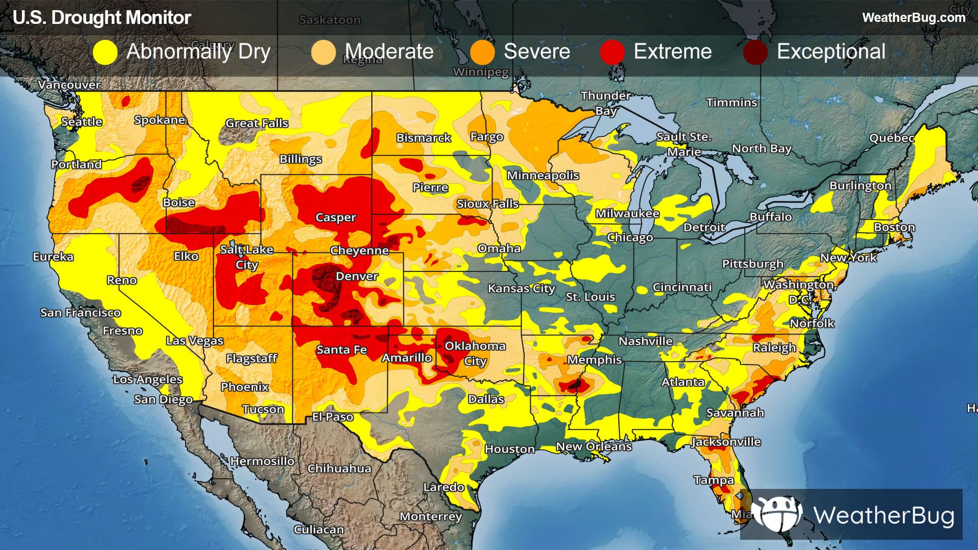
Rainfall was highly variable across the U.S. this week. While heavy rain and drought improvements were seen in localized parts across the central and southern U.S., widespread drought deterioration was most common this week.
West
High pressure brought unseasonably hot and dry conditions across most of the West this week. Monsoon storms provided anywhere from 0.5 to 3 inches of rain across much of Arizona and western New Mexico, with lighter rainfall in parts of Utah and the Great Basin. However, these amounts were not enough to offset long-term precipitation deficits.
Drought conditions worsened in parts of Montana and New Mexico, including the introduction of exceptional drought (D4) in northeastern New Mexico and expansion of moderate to extreme drought across central New Mexico. No areas experienced drought improvement. Dry conditions are also affecting agriculture, with poor or very poor rangeland conditions widespread across Arizona, New Mexico, and Utah, and 33% of Utah’s winter wheat rated poor or very poor. Persistent dryness has also severely reduced reservoir levels, with Lake Mead falling below 7 million acre-feet by August 10. This is its lowest level in records dating to 1937.
High Plains
The High Plains experienced warmer-than-normal temperatures and mostly dry conditions this week. Moderate to heavy rain brought limited relief to parts of eastern Kansas and Nebraska, with at least 0.5 inches also falling in parts of the Dakotas, Nebraska, Kansas, and higher elevations of Colorado. However, most areas received only a few tenths of an inch or less.
Drought improvements were limited to small areas of north-central and southeastern Nebraska, while dryness and drought persisted or worsened across much of Colorado, Kansas, Nebraska, and the Dakotas. Over the past 30 days, most of the region has received well below-normal precipitation, with central and southwestern Kansas and much of North Dakota receiving less than 25% of normal rainfall. Severe to exceptional drought (D2-D4) remains widespread across Colorado and Wyoming, while severe to extreme drought (D2-D3) affects much of Nebraska and parts of the Dakotas and Kansas.
Dry conditions are also taking a significant toll on agriculture and surface water resources. Poor or very poor pasture and rangeland conditions affect 64% of Colorado, 70% of Nebraska, and 75% of Wyoming, all well above their five-year averages. Several crops, including corn and sorghum in Colorado and North Dakota, are also reporting unusually high levels of poor or very poor conditions, with drought and dryness considered the primary contributing factors.
Midwest
Precipitation across the Midwest was highly variable this week. Dry conditions persisted across much of the northern tier and parts of central Illinois into southern Indiana, while heavier rainfall brought improvement to areas of Missouri, Iowa, and the southern Great Lakes. Over the past 30 days, much of northern Minnesota and Wisconsin has received less than 25% of normal precipitation, with several other areas receiving half of normal or less.
Meanwhile, above-normal rainfall occurred across parts of Minnesota, Iowa, Missouri, Indiana, Ohio, and Kentucky, creating a patchwork of drought conditions across the region. Severe drought (D2) remains most widespread across northern Wisconsin and central and northern Minnesota, with smaller areas affected in southwestern Minnesota and west-central Iowa.
South
Dryness and drought continued to expand and worsen across much of the South, with the most rapid deterioration occurring in Oklahoma, the Texas Panhandle, and nearby areas of Arkansas. Most states saw declining conditions this week, while Tennessee was the main exception, receiving heavier rainfall that improved conditions across central and eastern parts of the state. Oklahoma and northern Texas were especially dry, with much of Oklahoma receiving less than 25% of normal precipitation over the past 30 days.
Above normal temperatures across Oklahoma and northern Texas, further intensified drying. Although earlier rainfall has limited the development of more severe long-term impacts, crops, pastures, and streamflows are already being affected. Nearly half of Texas oats and more than one-third of Oklahoma soybeans are rated poor or very poor, while 44% of Oklahoma and 33% of Arkansas pastures and rangelands are in poor or very poor condition.
Southeast
Moderate to heavy rainfall brought widespread improvement across the Southeast, particularly along the I-95 Corridor and Piedmont. Improvements were more scattered along the coast and across Florida, while deterioration was limited to southern Alabama and Mississippi and a small area of southeastern Florida, where below normal rainfall and extreme heat have persisted.
Over the past 30 days, dry conditions have affected parts of Virginia, the Carolinas, Georgia, Florida, Alabama, and Mississippi, with most of Mississippi and southern Alabama receiving less than half of normal rainfall. Although rainfall over the past few months has generally been near or above normal, longer-term deficits remain significant, with many locations more than a foot below normal over the past year. These deficits continue to affect agriculture, with nearly half of North Carolina’s corn and 39% of South Carolina’s corn rated poor or very poor, along with degraded pasture and hay conditions in parts of Virginia and the Carolinas.
Northeast
Heavy rainfall brought widespread improvement from southern New England through Maryland, with 2 to 6 inches or more falling across parts of West Virginia, Pennsylvania, Maryland, New York, New Jersey, and Delaware. However, warmer-than-normal temperatures and below-normal rainfall caused dryness and drought to worsen across New Hampshire and Maine, including the expansion of abnormal dryness (D0), moderate drought (D1), and the introduction of severe drought (D2) along the Maine coast.
Despite recent rainfall, longer-term moisture deficits continue to cause impacts. Water supplies remain low in New Jersey, while agricultural conditions are poor in parts of the region. About 61% of West Virginia’s hay crop, 55% of its pastures, and 41% of Pennsylvania’s pastures are rated poor or very poor, along with nearly one-third of Maryland’s corn crop.
Looking Ahead
Looking ahead to the next drought outlook, moderate to heavy rainfall of more than 1 inch is expected across parts of the High Plains, northern Rockies, Colorado Rockies, Great Plains, Great Lakes, Ohio Valley, and portions of the Northeast and Southeast. The heaviest totals, exceeding 3 inches, are forecast for east-central Montana, northeastern Colorado, and a band from central Iowa into western Indiana. Meanwhile, much of the Pacific Coast, central and southern Plains, Lower Mississippi Valley, northern New England, and parts of the Great Basin and Rockies are expected to receive little precipitation.
Temperatures will vary significantly across the country. The south-central Plains through the Southeast are forecast to remain above normal, with the greatest heat from Arkansas through central Tennessee. In contrast, California, the Great Basin, northern Intermountain West, and northern Rockies and Plains are expected to average near to slightly below normal. Most other areas should see temperatures near normal.
------
Source: U.S. Drought Monitor