Multiple Areas at Risk for Strong Storms
Multiple locations will be at risk for strong to severe thunderstorms today as several storm systems move across the central and eastern U.S.
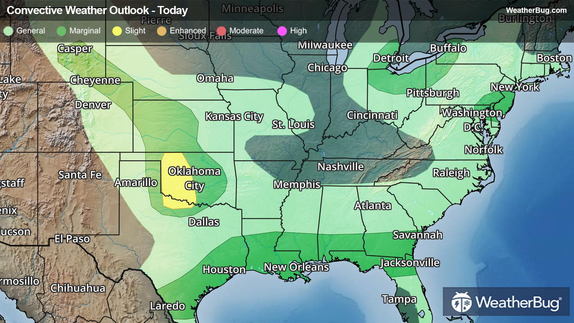
The most prevalent area of concern for today will be found across the south-central Plains. Here, a series of upper-air disturbances will help spark scattered strong-to-severe thunderstorms this afternoon and evening. As a result, the government's Storm Prediction Center has issued a Slight Risk, or a 2 out of 5 on the severe weather probability scale, across Oklahoma into northern Texas.
Damaging winds, large hail, and a few tornadoes will be possible today. Woodward, Okla., and Wichita Falls, Texas, are in this risk area, though nearby cities such as Oklahoma City should remain vigilant toward these thunderstorms.
The same front will also move through the eastern Great Lakes this afternoon and early evening. A few gusty thunderstorms will be possible across southeastern Michigan, northern Ohio, northwestern Pennsylvania, and western New York. Some small hail will also be possible with the stronger thunderstorms. Detroit, Cleveland, and Buffalo, N.Y., are at risk this afternoon.
A third area of concern for a few gusty thunderstorms will be found across southern and eastern Texas eastward to southern Georgia and northern Florida. An old frontal boundary combined with the heating of the day will help produce a few gusty thunderstorms this afternoon across the Gulf Coast states. Cities such as Houston, New Orleans, Mobile, Ala., and Jacksonville, Fla. may see one of these thunderstorms.
One final area of concern today is found across parts of the Mid-Atlantic. Here, enough breaks in the clouds may help strengthen isolated thunderstorms around Baltimore and Philadelphia to produce gusty winds and perhaps some small hail this afternoon.
Make sure to know the difference between a watch and a warning should they be issued. A watch means that conditions are favorable for severe weather to occur, and to be on alert for any rapidly changing conditions. A warning means that severe weather is imminent, and you should act fast to remain safe.
The best way to remain safe is to stay prepared and informed about your local weather. Have a severe weather kit packed with a battery-operated radio, water, and non-perishable food items should you be without power for long periods of time. Also, check the WeatherBug app frequently for any updates on today’s severe weather. Remember, “When Thunder Roars, Go Indoors!”