Severe Pattern Slides Northward Through Plains
The dangerous weather pattern in the plains persists as severe storms rally into the workweek.
Storms beginning Saturday afternoon have survived overnight, bringing ongoing severe weather concerns to southeastern Oklahoma and the Ark-La-Tex region before losing energy later this morning.
A Severe Thunderstorm Watch has been issued from southeastern Oklahoma and southwestern Arkansas to far northeastern Texas and northern Louisiana. This includes Shreveport and Monroe, La., Texarkana and El Dorado, Ark., and Tyler, Texas.
A low pressure region will continue to form in the southern Plains today as arid, desert air from the west clashes with a torrid inflow of Gulf air to the east. The unstable surface conditions this clash will create, alongside sharp upper-level energy sliding above the central Plains, will enable yet another bout of scattered severe thunderstorms today.
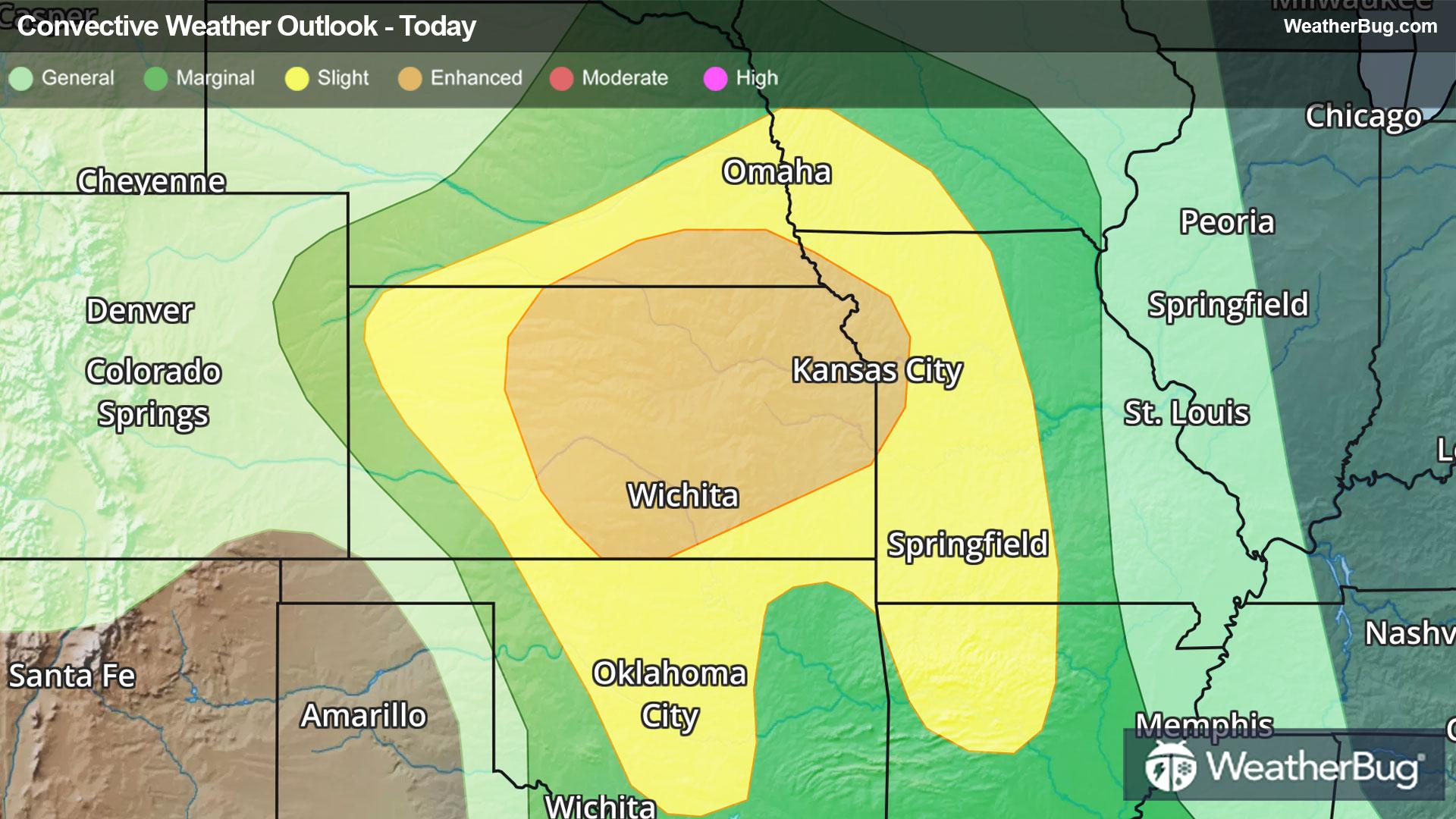
The government's Storm Prediction Center has issued an Enhanced Risk, or 3 out of 5 on the severe weather probability scale, covering central and eastern Kansas, far southeastern Nebraska, and far northwestern Missouri. Large hail, damaging winds, and tornadoes are all anticipated. Residents of Kansas City, Topeka, Wichita, and Overland Park should remain weather aware today, as scattered thunderstorms will be capable of producing damaging wind gusts, hail up to two inches in diameter, and isolated tornadoes, mainly in the evening.
A Slight Risk, or 3 out of 5 on the severe weather probability scale, also surrounds this threat and stretches into central Oklahoma, central Missouri, and western Kansas. Cities such as Omaha and Lincoln, Neb., Springfield, Mo., and Oklahoma City could observe isolated damaging wind gusts, large hail, and a few tornadoes today.
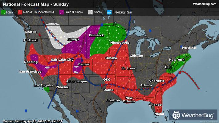
Heavy rain beneath these deep thunderstorms will also bring flooding concerns to the central Plains, where rain totals of one to two inches will be common. Areas where consecutive thunderstorms track will hold the greatest flood risk.
The severe weather threat migrates northeastward to begin the workweek, as the new low pressure system in the plains hitches a ride on the jet stream. Unfortunately, as the storm system intensifies on Monday afternoon and evening, so will its impacts.
So far, the Storm Prediction Center has posted an Enhanced Risk that encompasses all of Illinois, as well as parts of eastern Missouri, Iowa, and Arkansas, as well as western Kentucky, Indiana, and Tennessee. Folks in metropolitan areas such as Chicago and Springfield, Ill., St. Louis and Quincy, Mo., Burlington, Iowa, and Evansville, Ind. are at risk for scattered to numerous damaging wind gusts, widely scattered hailstorms with hail up to two inches in diameter, and isolated, strong tornadoes.
An encompassing Slight Risk has been posted alongside the core of the severe concerns on Monday. Although likely to see lesser coverage and intensity from severe thunderstorms, cities including Indianapolis, Milwaukee, Louisville, Ky., Memphis and Nashville, Tenn., Springfield, Mo., and Cincinnati, Ohio are still at risk.
On Tuesday and Wednesday, the ingredients for severe storms are expected to converge ahead of a burgeoning cold front that will sweep the Mid-South.
Make sure to know the difference between a watch and a warning should they be issued. A "watch" means that conditions are favorable for severe weather to occur, and to be on alert for any rapidly changing conditions. A "warning" means that severe weather is imminent, and you should act fast to remain safe.
The best way to remain safe is to stay prepared and informed about your local weather. Have a severe weather kit packed with a battery-operated radio, water, and non-perishable food items. Also, check the WeatherBug app frequently for any updates on today's severe weather. Remember, "When Thunder Roars, Go Indoors!"