Severe Storms Rumble Through the Ohio Valley
A potent cold front sinking southward into the Great Lakes and Midwest will trigger severe weather later this afternoon and evening.
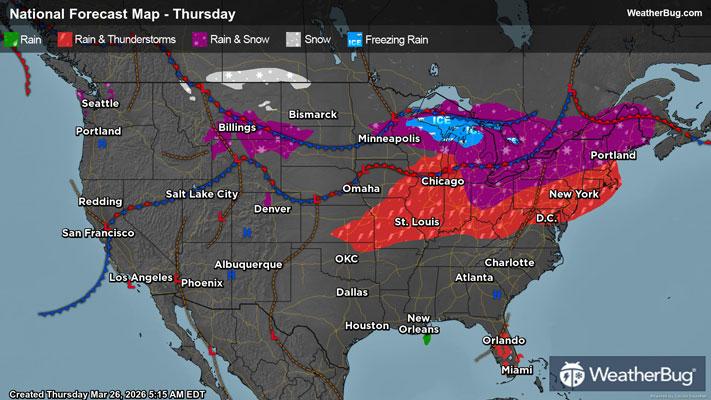
A developing low pressure system will move eastward along a frontal boundary from the northern Plains to the Great Lakes. This front separates an unseasonably warm and humid airmass to the south from an advancing cooler airmass. This clash of airmasses will result in explosive thunderstorm development across the lower Great Lakes and Midwest later this afternoon and evening.
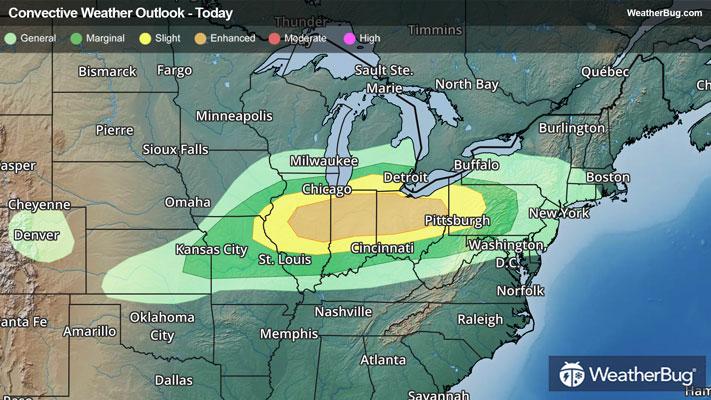
As a result of the expected severe thunderstorm threat, the government's Storm Prediction Center has issued an Enhanced Risk, or a 3 out of 5 on the severe weather probability scale, from central Illinois eastward through central and eastern Ohio. This area is surrounded by a Slight Risk, or a 2 out of 5 on the severe weather probability scale, across northeastern Missouri, western Illinois, southern Michigan, and western Pennsylvania.
All modes of severe weather can be expected today, including damaging winds, large hail, and even a few tornadoes. Cities such as Chicago, Indianapolis, Detroit, Cleveland, and Pittsburgh will be at risk for severe thunderstorms today.
In addition, torrential downpours will also be possible this afternoon into tonight. A quick 1 to 2 inches of rain could fall within these rounds of thunderstorms. Localized flooding is a possibility, especially near rivers, creeks and streams as well as urban, low-lying and more flood prone areas. If you do approach a flooded roadway, remember it’s always best to “Turn Around, Don’t Drown!”
Make sure to know the difference between a watch and a warning should they be issued. A "watch" means that conditions are favorable for severe weather to occur, and to be on alert for any rapidly changing conditions. A "warning" means that severe weather is imminent, and you should act fast to remain safe.
The best way to remain safe is to stay prepared and informed about your local weather. Have a severe weather kit packed with a battery-operated radio, water, and non-perishable food items. Also, check the WeatherBug app frequently for any updates on today's severe weather. Remember, "When Thunder Roars, Go Indoors!