Severe Thunderstorms Take Aim at the Plains, Midwest

Widespread severe thunderstorms, including very large hail and tornadoes, are likely across the Plains to the Midwest today.
Summer-like warmth and humidity has been building across the central U.S. to the Midwest thanks to a large high pressure system anchored near Florida. Meanwhile, a potent upper-air disturbance will send a fresh surge of cooler, drier air into the central U.S. today.
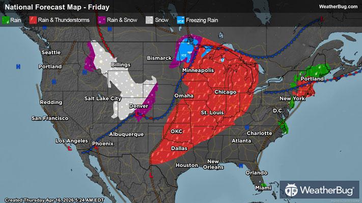
The collision of these two air masses will result in explosive thunderstorm development throughout the day today from northern Texas to Wisconsin, northwestern Indiana, and southwestern Michigan. This is where the government's Storm Prediction Center has issued both an Enhanced Risk, or 3 out of 5 on the severe weather probability scale, and a Slight Risk, or 2 out of 5 on the severe weather probability scale.
All modes of severe weather are expected today, including very large hail, damaging winds, and tornadoes.
Some cities at risk today include Oklahoma City, Wichita, Kan., Kansas City and St. Louis, Mo., Des Moines, Iowa, Chicago, and Milwaukee.
In addition to the thunderstorm threats, heavy downpours will be possible, leading to localized flooding concerns. Rainfall amounts of 1 to 2 inches will be possible, much of which will fall in a short period of time. Flood Watches have been issued across far eastern portions of Kansas into western and central Missouri. Flood Watches also remain in effect across parts of Wisconsin into Michigan. Remember, if you approach a flooded roadway, it is best to “Turn Around, Don’t Drown!”
The risk for severe thunderstorms will continue into Saturday across the upper Ohio Valley. A Slight Risk has been issued for portions of southwestern New York, western Pennsylvania, eastern Ohio, western West Virginia, and northeastern Kentucky. Charleston, W.V., Pittsburgh, and Cleveland are all at risk for thunderstorms capable of producing damaging winds, hail, and even an isolated tornado on Saturday.
Make sure to know the difference between a watch and a warning should they be issued. A "watch" means that conditions are favorable for severe weather to occur, and to be on alert for any rapidly changing conditions. A "warning" means that severe weather is imminent, and you should act fast to remain safe.
The best way to remain safe is to stay prepared and informed about your local weather. Have a severe weather kit packed with a battery-operated radio, water, and non-perishable food items. Also, check the WeatherBug app frequently for any updates on today's severe weather. Remember, "When Thunder Roars, Go Indoors!"