
Weekend Weather Outlook
This weekend, our active weather pattern will remain in place, with multiple disturbances impacting much of the country.
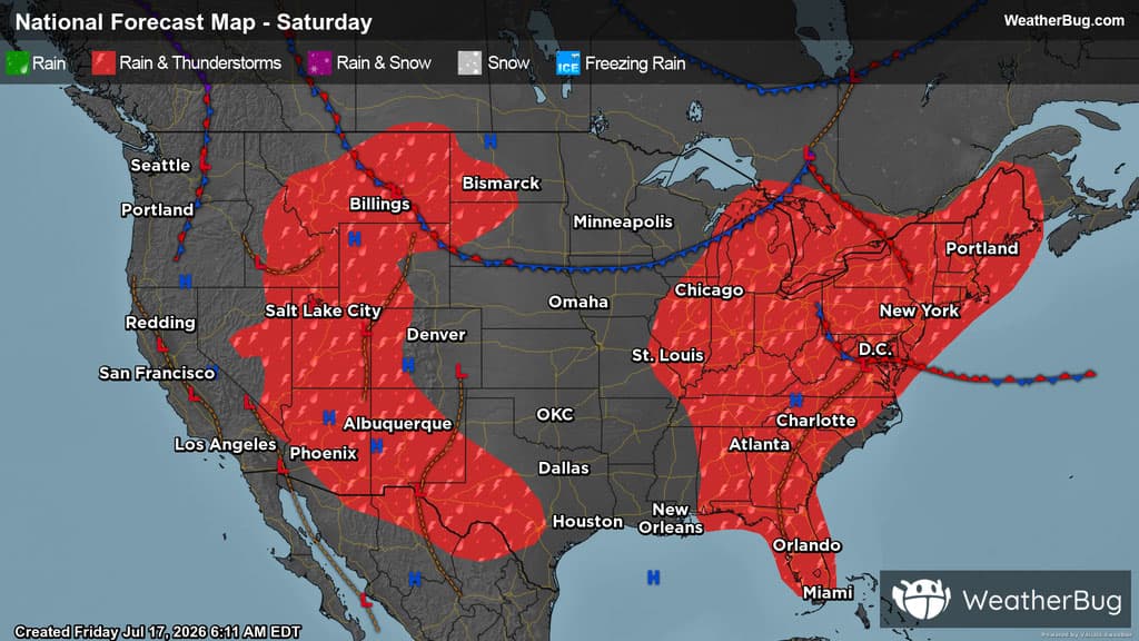
Saturday
Previous showers and thunderstorms from Friday night will linger into Saturday morning. Expect partly to mostly cloudy skies, showers, and thunderstorms in parts of the East Coast, Upper Midwest, Lower Plains, Desert Southwest, and Mountain West. Isolated storm cells will be seen in the Lower Midwest and interior Southeast as well.
By the afternoon, weather activity will become more widespread, as a line of storms erupts in the Lower Midwest stretching into the interior Northeast. Additionally, widespread storms will initiate in much of New England and the Mid Atlantic. There is a threat of severe weather in the aforementioned regions, where storms could bring damaging wind, hail, and even isolated tornadoes. Remember, the best way to stay safe is to be prepared and informed about your local weather, such as checking the WeatherBug app for any weather updates and that “When Thunder Roars, Go Indoors!”
Scattered storm cells will also spark in the Southeast. Meanwhile, monsoonal moisture in the West will help to initiate widespread showers and thunderstorms throughout the Desert Southwest, Great Basin, and the Rocky Mountain region.
In the Southwest, rainfall totals up to 3 inches cannot be ruled out. After several days of persistent rain and already saturated soils, anyone in these areas should be prepared for flooding and rapidly changing weather conditions. This is especially the case near creeks, rivers and streams as well as urban, low-lying and other more flood prone areas. If you do approach a flooded roadway, remember that it is always best to “Turn Around, Don’t Drown!”
Throughout the day, isolated showers may occur in the Pacific Northwest. However, much of the West Coast along with the Central Plains are expected to be high and dry, with clear to partly cloudy skies.
High temperatures in the high 80s through the 90s will remain in the forecast for much of the Mid-Atlantic, the Southeast South-Central U.S., along with much Midwest and High Plains. Temperatures could even climb into the triple digits in some areas. However, the Appalachian spine and the northernmost points of the Upper Midwest and High Plains will see cooler temperatures in the 70s. In the Northeast, highs will range from the 70s to the 80s, however the northernmost points of New England will be cooler in the 60s.
The Western U.S. will see great variations in high temperatures, ranging from the 80s to well over 100 degrees, where much of the latter will be seen in the Desert Southwest. In the Mountain West, regions of higher elevations can expect temperatures in the 50s and 60s. Meanwhile, the rest of the U.S. can mostly expect highs ranging from the upper 70s to the 90s.
Sunday
Two cold fronts will impact the eastern two-thirds of the U.S. on Sunday, while monsoonal moisture flows into the Mountain West. The first cold front will inch south and east across the Eastern U.S. The second cold front will slice through the north-central U.S.
Rain showers and a few thunderstorms will be found from the Northeast into the Appalachian Spine in the morning. The northern Plains, eastern Gulf Coast, the southern High Plains and the Desert Southwest could also see showers and thunderstorms early in the morning. By the afternoon and evening, showers and thunderstorms will become more widespread, including throughout the Mountain West, most of the Plains and Mississippi Valley and the Southeast. A few showers and thunderstorms could also occur in the interior Northeast.
Across parts of the Southeast, there will be the potential for thunderstorms to become strong to severe. The main threat would be damaging wind gusts. However, large hail and an isolated tornado or two cannot be ruled out. The Mountain West and Northeast will be susceptible to torrential downpours. These downpours could lead to flooding, especially near rivers, creeks and streams as well as urban and low-lying areas.
A few spots will be free of weather headaches for the end of the weekend. This includes the Northwest and California along with the western Gulf Coast and Great Lakes.
Near to above normal temperatures are in store for much of the West Coast into the north central U.S. and Mississippi Valley. Cooler than normal weather is expected for the Desert Southwest, southern High Plains and most of the Eastern Seaboard as a result of cloud cover and rain/thunderstorm chances.
Expect 70s and lower 80s across the Great Lakes, Appalachian Spine and Northeast, but the far interior Northeast could only see highs in the 50s and 60s. The higher elevations of the Mountain West and the immediate West Coast will also report highs mainly in the 70s and 80s, but 50s and 60s are possible in the tallest peaks of Colorado. Much of the U.S. will have temperatures peak in the 80s and 90s across the interior Northwest, Great Basin, Plains, Deep Southeast and Southeast. Triple digit heat will persist across California’s Central Valley into the Desert Southwest.