
Severe Weather Targets the Central U.S.
A new round of severe thunderstorms will take aim across portions of the central Plains into the Midwest later this afternoon and evening.
An area of low pressure will gather strength over parts of Oklahoma and Kansas throughout the day. This low pressure system will help continue to draw plenty of warm and humid northward, while some cooler and drier air sinks southward behind this system. The resulting clash in air masses will result in scattered strong to severe thunderstorms later this afternoon and evening.
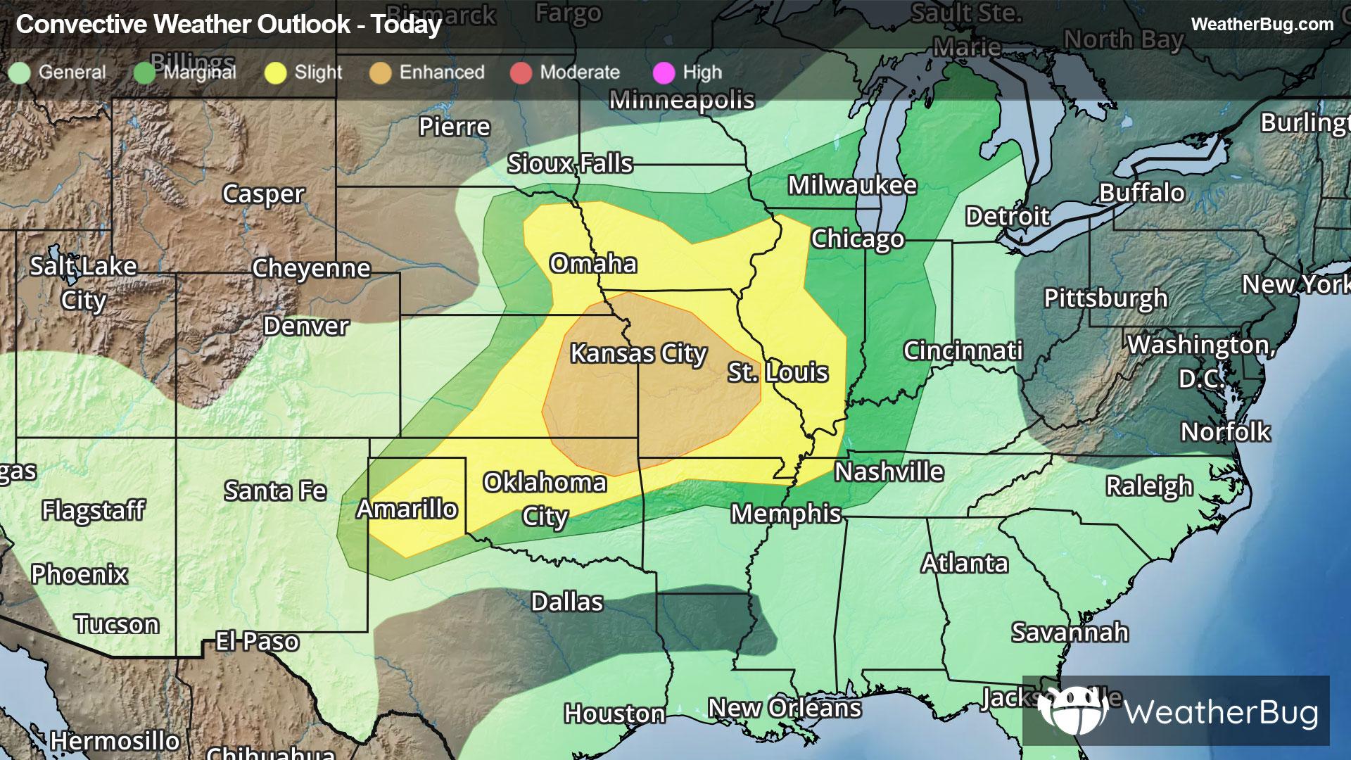
As a result, the government's Storm Prediction Center has issued a large Slight Risk, or a 2 out of 5 on the severe weather probability scale, across the Texas Panhandle, much of Oklahoma, central and eastern Kansas, eastern Nebraska, southern Iowa, Missouri, northern Arkansas, western Illinois, far western Kentucky, and far northwestern Tennessee.
Within this area, an Enhanced Risk, or a 3 out of 5 on the severe weather probability scale, covers northeastern Oklahoma, eastern Kansas, far southeastern Nebraska, and much of Missouri.
Cities such as Amarillo, Texas, Oklahoma City, Wichita, Kan., Kansas City and St. Louis, Mo., Des Moines, Iowa, and Springfield, Ill. are all at risk today. These risks include damaging winds, large hail, heavy downpours, and a few tornadoes.
In addition to the severe thunderstorms, heavy rain is expected across portions of eastern Kansas, western Missouri, northwestern Arkansas, and northeastern Oklahoma. Rain amounts of 1 to 3 inches will be expected, with localized rain amounts up to 5 inches possible. As a result, Flood Watches have been issued in these areas. Remember, if you approach a roadway covered in water, it is best to “Turn Around, Don’t Drown!”
The focus for severe weather will return to the eastern U.S. for Sunday. Raleigh, N.C., Richmond, Va., Washington, Baltimore, Pittsburgh, Philadelphia, and New York are all at risk on Sunday.
Make sure to know the difference between a watch and a warning should they be issued. A "watch" means that conditions are favorable for severe weather to occur, and to be on alert for any rapidly changing conditions. A "warning" means that severe weather is imminent, and you should act fast to remain safe.
The best way to remain safe is to stay prepared and informed about your local weather. Have a severe weather kit packed with a battery-operated radio, water, and non-perishable food items. Also, check the WeatherBug app frequently for any updates on today's severe weather. Remember, "When Thunder Roars, Go Indoors!"