
Snow, High Winds Plague Great Lakes With Blizzard Conditions
While severe weather will occur along the leading edge, a powerful cold front brings snowy, winter-like conditions and chilly temperatures to the eastern half of the U.S. for the start of the work week.
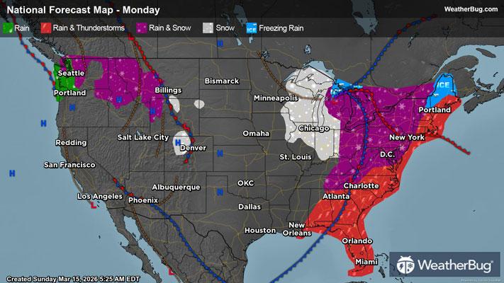
A large, slow-moving low pressure system will drift from the Great Lakes into southeastern Canada today. Associated with this system, a cold front will also make its way across the Eastern U.S. Warm, humid air will be found throughout the East ahead of this cold front, while cold, drier air attempts to filter in behind it. This collision of air masses will be the catalyst for severe weather throughout the Eastern Seaboard. However, to the north and west of this system, cold air from Canada and just enough lingering moisture will create winter-like weather conditions in the wake of this cold front.
Snow will be the predominant precipitation type throughout the Great Lakes today. Here, moderate to briefly heavy snow is expected through midday, tapering to flurries or light snow for the afternoon and evening. Though, freezing rain and sleet will mix in with snow across northern portions of Michigan’s Lower Peninsula.
The Ohio and Tennessee valleys will experience rain and thunderstorms through late morning or early afternoon. Rain will then transition over to snow for the rest of today. Even parts of northern Louisiana, Mississippi, Alabama and northern Georgia could see some wet snow today! The Appalachian Spine will also be soaked by rain and thunderstorms into early afternoon, which will change over to a wintry mix of snow, sleet and even some freezing rain.
Rain and thunderstorms will be in the forecast for the Northeast and Mid-Atlantic today. Interior portions of the Northeast and Mid-Atlantic will likely see rain mix with and change over to snow, sleet, freezing rain and rain tonight into early Tuesday morning. At the same time, expect mainly rain for areas closer to the coast.
Precipitation will quickly come to an end across the Eastern U.S. by mid to late morning on Tuesday. The exception will be areas downwind from the Great Lakes, where a persistent northwest wind leads to lake-effect snow. This lake-effect snow will continue for most of Tuesday, then a new weather system brings a chance of snow to the Midwest late Tuesday into Wednesday.
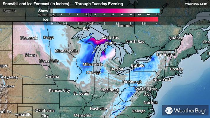
When all is said and done, most areas that see snow today into Tuesday will end up with new snowfall accumulations ranging from a Trace up to 2 inches of snow. Higher snowfall amounts are likely though for eastern/southern Wisconsin, eastern Iowa, northern Illinois, all of Michigan’s Upper Peninsula and northern parts of Michigan’s Lower Peninsula. Here, new snowfall amounts of 2 to 6 inches are likely, with some locally higher amounts up to 8 to 10 inches. In addition, new ice accumulation of up to one-tenth inch.
Blizzard Warnings are in effect across far southeastern Minnesota, much of Iowa, northwestern Illinois, most of Wisconsin, Michigan’s Upper Peninsula and far northern portions of Michigan’s Lower Peninsula. An Ice Storm Warning and Winter Storm Warning has also been issued for the rest of northern portions of Michigan’s Lower Peninsula.
Winter Weather Advisories stretch across the rest of southern Minnesota, northwestern Wisconsin, far northeastern Kansas, northern Missouri, central into northeastern Illinois, western parts of Michigan’s Lower Peninsula and far northern Indiana. An additional Winter Weather Advisory covers central Pennsylvania into western Maryland and eastern West Virginia.
Widespread gusts of 45 to 60 mph or higher are also expected to travel ahead of, alongside, and behind the storm’s cold front. High-profile vehicles will be susceptible to tipping when crossing these high winds, which could pair with snowfall and low visibility to produce dangerous to impossible travel for most vehicles.
High Wind Watches, Wind Advisories, and High Wind Warnings cover a vast majority of the Midwest, and the Great Lakes region into northern and western New York. These impactful gusts will make driving difficult, especially for high-profile vehicles, and may lead to widespread power outages.
Be sure to download the WeatherBug app to stay up to date on the latest on this changing weather. It’s never too early to have a supply kit packed in case of inclement weather. A simple kit including a weather radio, water, blankets, batteries, and non-perishable food items will go a long way in the event of a power outage. It’s always best to avoid traveling in rough weather as the roads will be dangerous.