


Tropical Disturbance Forming Near Louisiana Coast
As August comes to an end, the Atlantic tropics begin to churn up another storm.
A tropical disturbance moving though westward through the northern Gulf will likely form into a depression or storm to begin the new work week. This system will later move ashore in eastern Texas heading into the midweek.
As of 4 a.m. CDT (5 a.m. EDT), the disturbance was about 100 to 150 miles south of the coast of southern Louisiana. This system is feeding off the Gulf’s warm water, further developing thunderstorms, and is anticipated to become better organized.
The circulation center is the primary condition for the National Hurricane Center to consider it a tropical depression, and it is likely that this designation will be given in the next 24 hours or so. Further intensification would take the system to tropical storm levels, where it would be given the next name, “Edouard.” The system will slowly move towards the west-northwest across the northwestern Gulf, ultimately reaching the eastern Texas Gulf coast later Tuesday or early Wednesday before moving inland.
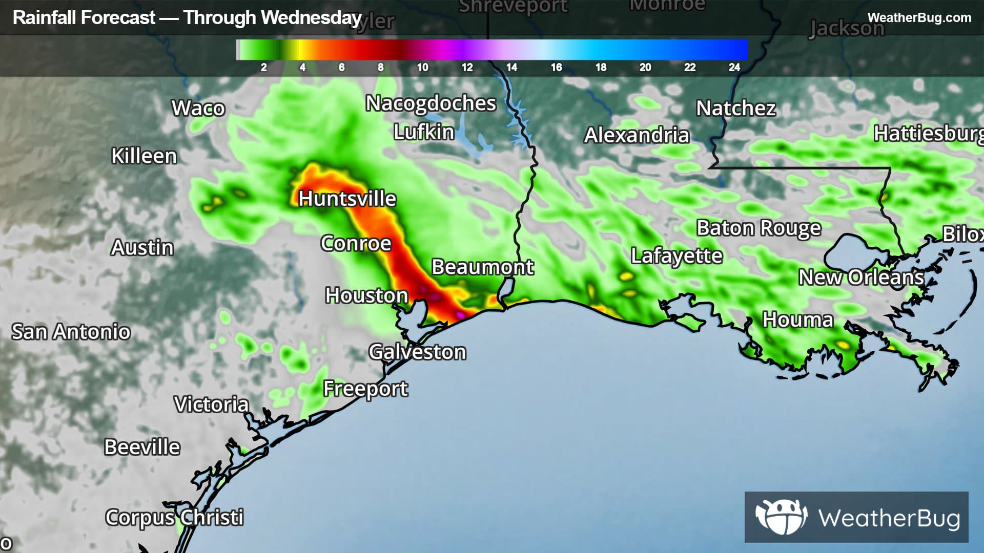
Even if this system remains just a disturbance rather than a depression or storm, heavy rainfall is still expected. Heavy rain will continue for the Louisiana coast through today, later spreading to the eastern Texas coast between Houston and Port Arthur Tuesday and Wednesday. Rain totals of 2 to 4 inches will be common for southeastern Texas. Those within heavier thunderstorms may see as high as 5 to 8 inches! For the Louisiana coast from the Texas border to Morgan City, La., up to 2 to 2.5 inches of rain will be likely through Tuesday morning. This kind of rainfall will likely produce flooding, so remember “Turn Around, Don’t Drown!”
Strong winds are less of a threat compared to the heavy rain. Those nearing the center of this system will see occasional gusts nearing 30 to 40 mph Tuesday into Wednesday. Those further out from the center, like in Houston and Lake Charles, La., may only see gusts up to 20 to 30 mph.
The Atlantic hurricane season has been relatively slow thus far, with the fourth named storm, Dolly, briefly forming last week. However, Dolly’s remnant moisture has remained intact and is moving across the southeastern Bahamas, Puerto Rico and the Virgin Islands. The moisture is expected to cross southern Florida by mid-week, potentially becoming better organized in the Gulf late in the week.
The peak of the hurricane season is in mid-September, so the increase in activity is right on schedule. Be sure to use this time to check your storm preparedness by maintaining your go-kit of water, batteries, chargers, food, and blankets. Scout out multiple evacuation routes in case your preferred one is blocked or traffic-jammed as the next storm approaches. And, of course, check WeatherBug for the latest on the tropics throughout the season.