


Tropical Disturbance Forms Near Louisiana Coast
As the calendar prepares to switch to September, the Atlantic tropics are starting to percolate.
A strengthening tropical disturbance is moving across the western Gulf of Mexico and has a good chance to form into a depression or storm before moving ashore this week.
As of 1 p.m. CDT (2 p.m. EDT), the disturbance was about 100-200 miles south of the mouth of the Mississippi River. While still disorganized, interaction with the warm Gulf water is helping the system to develop thunderstorms and even a point for those thunderstorms to circulate around.
The circulation center is the primary condition for the National Hurricane Center to consider it a tropical depression, and it is likely that this designation will be given in the next 24 hours or so. Further intensification would take the system to tropical storm levels, where it would be given the next name, “Edouard.” The system will move northwestward across the northern Gulf, ultimately reaching the eastern Texas Gulf coast later Tuesday or early Wednesday before moving inland.
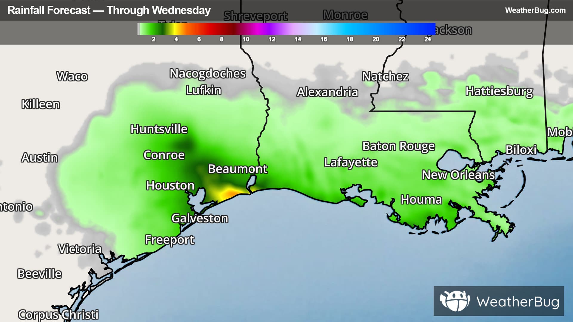
Regardless of whether it remains a disturbance or levels-up to a depression or storm, the threats are the same. Heavy rainfall will spread along the Louisiana coast tonight into Monday, encompassing the eastern Texas coast between Houston and Port Arthur on Tuesday into Wednesday. Downpours of 2 to 4 inches will be common across eastern Texas, including the metro Houston area, with locally as much as 6-8 inches where heavier thunderstorms occur. The Louisiana coast as far east as Morgan City can expect to see one-half to as much as 2 inches of rain through Tuesday morning. This kind of rainfall will likely produce flooding, so remember “Turn Around, Don’t Drown!”
Along with the lack of organization, the disturbance remains relatively weak, and so strong winds are less of a factor. Areas close to the center could see occasional gusts of 30-40 mph on Tuesday and early Wednesday, while locales further out – Houston and Lake Charles – might see gusts of 20-30 mph this week.
The Atlantic hurricane season has been relatively slow thus far, with the fourth named storm, Dolly, briefly forming this week. However, Dolly’s remnant moisture has remained intact and is moving across the southeastern Bahamas, Puerto Rico and the Virgin Islands. The moisture is expected to cross southern Florida by mid-week, potentially becoming better organized in the Gulf late in the week.
The peak of the hurricane season is in about two weeks, so the increase in activity is right on schedule. Be sure to use this time to check your storm preparedness by maintaining your go-kit of water, batteries, chargers, food and blankets. Scout out multiple evacuation routes in case your preferred one is blocked or traffic-jammed as the next storm approaches. And, of course, check WeatherBug for the latest on the tropics throughout the season.