Weekend Weather Outlook
Unsettled weather lingers in the East on Saturday before a warmer, quieter spring pattern spreads across much of the country on Sunday.
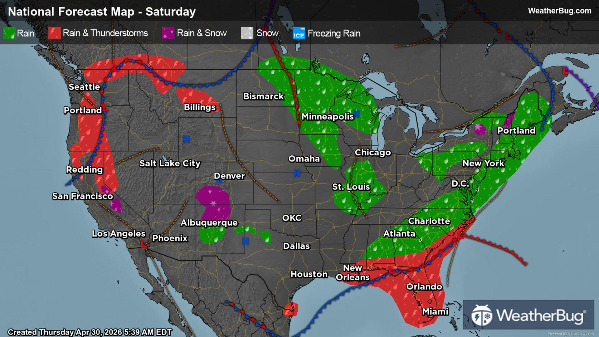
Saturday
An upper‑level low pressure system will continue to trudge east, producing periods of rain from the Midwest and Ohio Valley into the Northeast. At the same time, low pressure developing across the Southeast will lift north toward the Mid‑Atlantic during the day before tracking northeast at night. As this system evolves, wraparound rain will spread back toward the coast from the Delmarva through southern New England, including southern Maine. While occasional rain may reach inland areas, the heaviest and most persistent rainfall is expected to remain offshore.
To the south, a stalled front along the Gulf Coast and Southeast coastline will keep showers and thunderstorms ongoing from Louisiana through Mississippi, Alabama, Georgia, and into Florida. Stronger storms are most likely closer to the Atlantic coast, particularly from southern Georgia into the Florida Peninsula, where heavy rain, gusty winds, frequent lightning, and localized flooding are possible.
High pressure remains firmly in control across much of the nation’s midsection, providing a quiet break from recent storms. Farther north, a weak disturbance may spark a few late‑day showers across eastern North Dakota and northern Minnesota.
The West will contend with an unsettled conditions as periods of rain and scattered thunderstorms develop over Washington and Oregon, with rain extending into northern California and Nevada. The interior West and Southwest remain mostly dry though a few showers could pop up over the Rockies.
Temperatures show a strong spring contrast as cooler air lingers across the northern tier, with highs in the 30s and 40s in northern Minnesota and Upper Michigan. Most of the Great Lakes, interior Northeast, and Upper Midwest will top out in the upper 40s and low 50s.
The Midwest and Ohio Valley warm slightly into the 50s and low 60s, while the central Plains climb into the upper 60s and low 70s. Milder conditions continue across the Southeast, with highs mainly in the mid to upper 60s from the Carolinas into Georgia and Alabama. Florida remains the warm spot in the East, reaching the upper 80s and lower 90s.
The Pacific Northwest reaches the 70s, while 70s and 80s spread across California, the Great Basin, and much of the Rockies. The Desert Southwest remains hot, with widespread upper 80s and 90s across southern California and Arizona.
Sunday
Sunday brings a noticeable shift toward a warmer and tamer weather pattern across much of the U.S.
Across the Northeast, lingering moisture will keep scattered showers in place through the afternoon. The Southeast to the Carolinas will dry out, while Florida will remain unsettled with scattered rain and thunderstorms as a cold front passes through the Sunshine state.
A system dropping in from Canada will bring scattered showers back to the northern Plains and into the Upper Midwest and Great Lakes, including the Dakotas, Minnesota, Wisconsin, and northern Michigan. Enough instability will be present for isolated thunderstorms.
In the West, scattered showers and isolated thunderstorms will affect the interior Rockies and Southwest, including parts of Colorado, Utah, New Mexico, Arizona, and Nevada. Rain is also anticipated across northern California, including the Sierra Nevada, with locally heavy rain in the higher terrain. Farther north, showers will brush parts of the northern Rockies, while the Pacific Northwest trends mostly dry. Central and southern California will remain largely dry, with continued mild to warm spring conditions.
Temperatures surge above average for many locations. Much of the central Plains and Midwest warm into the 70s and lower 80s, with Kansas, Nebraska, Missouri, and Iowa enjoying some of the most pleasant conditions of the weekend.
Widespread mid 70s to lower 80s will occur from Texas through the lower Mississippi Valley and into the Deep South. Florida stays warm, as highs climb into the low to mid 80s.
The Southeast and Mid‑Atlantic warm into the upper 60s and 70s, while much of the Ohio Valley and Great Lakes see highs in the 60s. The Northeast remains the coolest region, with highs mainly in the 40s and 50s, especially across northern New England.
The Pacific Northwest surges to the 70s and low 80s, California climbs into the 80s and low 90s, and the Desert Southwest is the hottest region in the country with widespread 90s across Arizona and southern California.