
Weekend Weather Preview
A low pressure system will stretch across the eastern half of the country this weekend as stormy weather plagues many weekend plans.
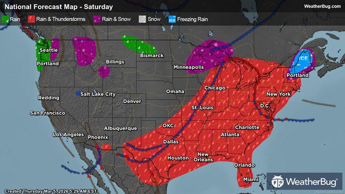
Saturday
On Saturday, moisture will extend into the Northeast, bringing rain showers to the area for most of the day. As a frontal boundary stretches up the East Coast, storms will begin to sweep over more southern parts of the Northeast, but New England will mostly just see rain showers. Maine has the possibility to see some icy conditions as well.
In the Mid-Atlantic, a similar trend to the Northeast will follow. Dry weather will persist through the morning hours, but come afternoon, rain will begin. A line of thunderstorms will begin to impact the Mid-Atlantic by the evening.
The Southeast will also see some rainfall, but most of the rain will cling to the Appalachians on Saturday. Coastal regions of the Southeast will not see significant impacts until Sunday when the cold front moves through. However, Florida will see rain showers and isolated thunderstorms throughout the day in combination with the higher temperatures for the area. Heavy bouts of rain are possible with these isolated storms.
The Deep South will see the most intense versions of the storms associated with this low pressure. Storms within this region have potential to become severe on Saturday. Gusty winds, heavy precipitation, lightning, and hail are all possible during the passing of these storms. An isolated tornado or two also cannot be ruled out.
The Midwest will experience its fair share of precipitation this Saturday as snow showers fall on the Northern Plains. Rain can be expected around the Great Lakes down into the Southern Plains.
The Mountain West will be relatively dry this Saturday, with some snow showers falling around Denver and the Northern Rockies. With this snow, there will be a rain/snow mix, where cold rain falls to lowland areas, and snow falls on higher mountainous peaks.
The Pacific Northwest will see another wet weekend ahead as rain showers will impact the central coast of Oregon up through the Seattle metro in Washington state. Higher amounts of precipitation will cling to the Cascades, bringing some additional snowfall to the mountain peaks.
The Desert Southwest, unlike most of the country, will see dry weather conditions this Saturday.
Below-freezing temperatures return this weekend as the U.S.-Canada border in the Northern Plains, the Rockies, Cascades, and Sierra Nevada all see temperatures below freezing. Thirties are also in store for the foothills surrounding these mountain ranges.
Areas seeing 40-degree temperatures will be New England, the northern Great Lakes, some areas in the Northern Plains, the Pacific Northwest, and lowland areas in the Great Basin Desert. Fifties can be expected for most of the Northeast, the Central and Southern Plains, and California’s Central Valley.
Warming up to the 60s will be the northern Mid-Atlantic and parts of the Southern Plains. Many regions will see 70s this Saturday as the Ohio River Valley, Tennessee Valley, Arkansas, Central Texas, and the Desert Southwest will see these temperatures.
Warming up to meteorological spring will be the Gulf Coast states, with temperatures reaching the mid-80s along the coast.
Sunday
Come Sunday, wet weather conditions will continue in the Northeast, albeit precipitation intensity will be lower. By late evening on Sunday, only coastal areas within the Northeast will see some continued rainfall.
In the Mid-Atlantic, the passing of a front will bring continued rainfall throughout the day. Sunday will be a dreary, wet, rainy day for most people residing in the Mid-Atlantic.
For the Southeast, the continued passing of a front will bring some isolated thunderstorms to the area in the early morning hours and again in the afternoon as daytime temperatures begin to warm up the region. Thunderstorms will not be nearly as intense as Saturday, but bouts of heavier rain are still possible on Sunday.
The Deep South will continue to see some strong thunderstorms throughout the day on Sunday as they pass through and slow down as the frontal system stretches across the area. Bouts of heavy rain will continue throughout the day, with another dreary, wet, rainy, and windy day ahead.
The Midwest will be mostly dry on Sunday. Some remnants of rainfall will continue to trail across the southern Great Lakes and Southern Plains, but this rainfall will be light.
Dry weather conditions will continue in the Mountain West on Sunday. In the Northern Rockies along the U.S.-Canada border, there will be some rainfall in the valleys and snow topping the mountains. However, the precipitation will remain isolated to this area only.
The Pacific Northwest will experience an additional weekend day of rainy weather. Rain will continue from the central coast of Oregon up through the Seattle metro in Washington state.
Although it’s dry on Saturday, the Desert Southwest will see some light rainfall on Sunday. Weekend plans outside will likely be rained on, bringing many South-westerners indoors to end the weekend.
Sunday will warm up for most of the country, as the Rockies, Cascades, and Sierra Nevada will be the only areas seeing temperatures below freezing!
Areas seeing 40s will be the U.S.-Canada border in the Northeast, as well as the border in the Northern Plains and Pacific Northwest. Additionally, the foothills of the Rockies and the Great Basin Desert should expect 40-degree temperatures. Fifties are in store for the Northeast, Great Lakes, Northern Plains, and the Pacific Northwest.
Sixties will be present along the Mid-Atlantic coast, Tennessee Valley, Central and Southern Plains, and most of California, with exception to the Desert Southwest and Sierra Nevada.
Seventies will be seen in most of the Southeast down through Louisiana and the Gulf Coast of Texas. The Desert Southwest will also be in the 70s. The Rio Grande Valley and Florida will be in the 80s.