
Weekend Weather Preview
The nation should prepare for a wet weekend, as storms, snow, and Pacific moisture bring soaking rain to most of the country by Sunday night.
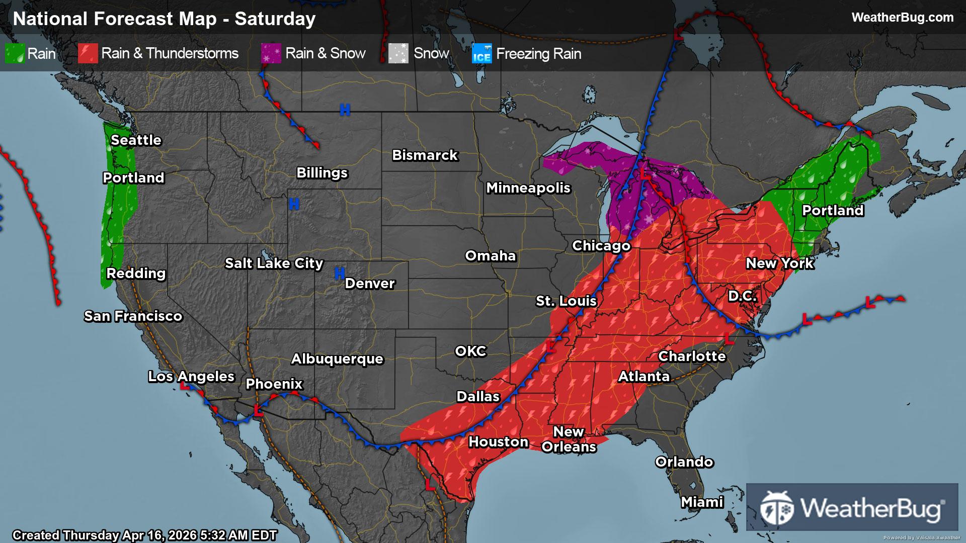
Saturday
In the Northeast, remnants of Friday evening rain should make its way offshore by midday but will be replaced by new rain showers and storms as a line of thunderstorms makes its way into the area. By Saturday evening, rain showers and thunderstorms will be present, giving the region only a few hours of dry weather.
In the Midwest, this line of thunderstorms makes its debut as it swings across the Great Lakes, leaving rain showers and thunderstorms from the southern Plains to the Great Lakes. A rain and snow mix can be expected in the northern Plains and northern Great Lakes, where temperatures will hover near freezing, creating a cold rain for most.
The Southeast and Gulf Coast should expect similar conditions, with some warmer weather intensifying storms and bringing a muggy, humid, warm, and rainy day to the region this Saturday. This line of storms should not reach Florida by Saturday evening; however, southern Florida will still see some storms as daytime heating influences some pop-up thunderstorms in the area.
High pressure over the Mountain West will save Saturday outdoor plans for some, but moisture will cling to the Denver metro area, raining down on any outdoor-related events during the day. With this moisture, some additional snow will top the mountainous peaks. Farther south in the southern Rockies will be dry, as well as the northern Rockies this Saturday.
The entire West Coast should expect some dry weather bliss this Saturday. The Pacific Northwest, Great Basin Desert, and Desert Southwest will all experience dry weather conditions, until some moisture begins to move into the Pacific Northwest late Saturday evening.
Saturday chills settle in as areas seeing temperatures in the 30s will be the northern Plains and Rockies. Forty-degree temperatures will be seen within the northern Great Lakes, central Plains, and lowland areas of the Rockies. Fifty-degree sweater weather will be seen on the New England coastline, Great Lakes, southern Plains, and Pacific Northwest.
Areas seeing the 60s this Saturday are Northeastern coastlines, the Great Lakes, Texas, and California’s Central Valley. Seventies will be more prominent across the country in areas such as the Northeast, Ohio River Valley, southern Plains, and Desert Southwest.
Hot weather will be seen where 80s are present, such as the northern Mid-Atlantic and Gulf Coast. Spiking up to the 90s will be Florida and some areas in the Southeast.
Sunday
As rainy weather conditions continue to move eastward, the Northeast will see continuous rain throughout the day on Sunday. A rain and snow mix will top the northern Appalachians and Adirondacks northward, leaving populated areas rainy throughout the day.
The Southeast and Deep South should expect similar conditions this Sunday, with rain continuing throughout the day. The line of thunderstorms that were inching its way through the Southeast on Saturday will continue through Sunday, impacting Florida up through North Carolina until exiting offshore by Sunday evening. Daytime heating will keep Florida booming throughout the day as thunderstorms should be expected throughout the whole state.
The Midwest will have some quiet after the storm on Sunday, with high pressure moving in, keeping weather conditions clear throughout the Plains, and leaving behind some residual light rain showers in the Great Lakes region. The U.S.-Canada border should expect a chilly, rain snow mix to accompany rain showers in the region.
The Mountain West, however, will receive a day off from rain, ending the weekend on a dry note. Sunday weather should be dry throughout the Rockies, leaving outdoor plans to be continued.
Although most of the day will be dry for the West Coast, Pacific moisture will inch its way onshore, bringing rain showers to the Pacific Northwest, and topping the Cascades and Sierra Nevada with some fresh snow.
Both the Desert Southwest and Great Basin Desert escape plan-ruining rainy weather as they will stay dry throughout the day on Sunday.
Below-freezing temperatures will stay segregated this Sunday to the northern Great Lakes and mountain peaks in the Rockies, Sierra Nevada, and Cascades. Forties will be more prevalent in the country, encompassing the northern Plains, southern Great Lakes, and foothills of mountain ranges.
Areas seeing 50s this Sunday will be the Northeast, Ohio River Valley, northern Plains, lowland regions in the Rockies, the Pacific Northwest, and Great Basin Desert. Regions in the 60s will be Northeastern coastlines, central and southern Plains, the Gulf Coast (except for Florida), and California’s Central Valley.
Seventies will be present in the Mid-Atlantic, Desert Southwest, and Rio Grande Valley. Eighties mostly keep to Florida and more arid regions of the Desert Southwest this Sunday.