10-Day Weather Forecast - Ashland, NY
- 66|57°F
 40% Chance of StormsHourly details
Today
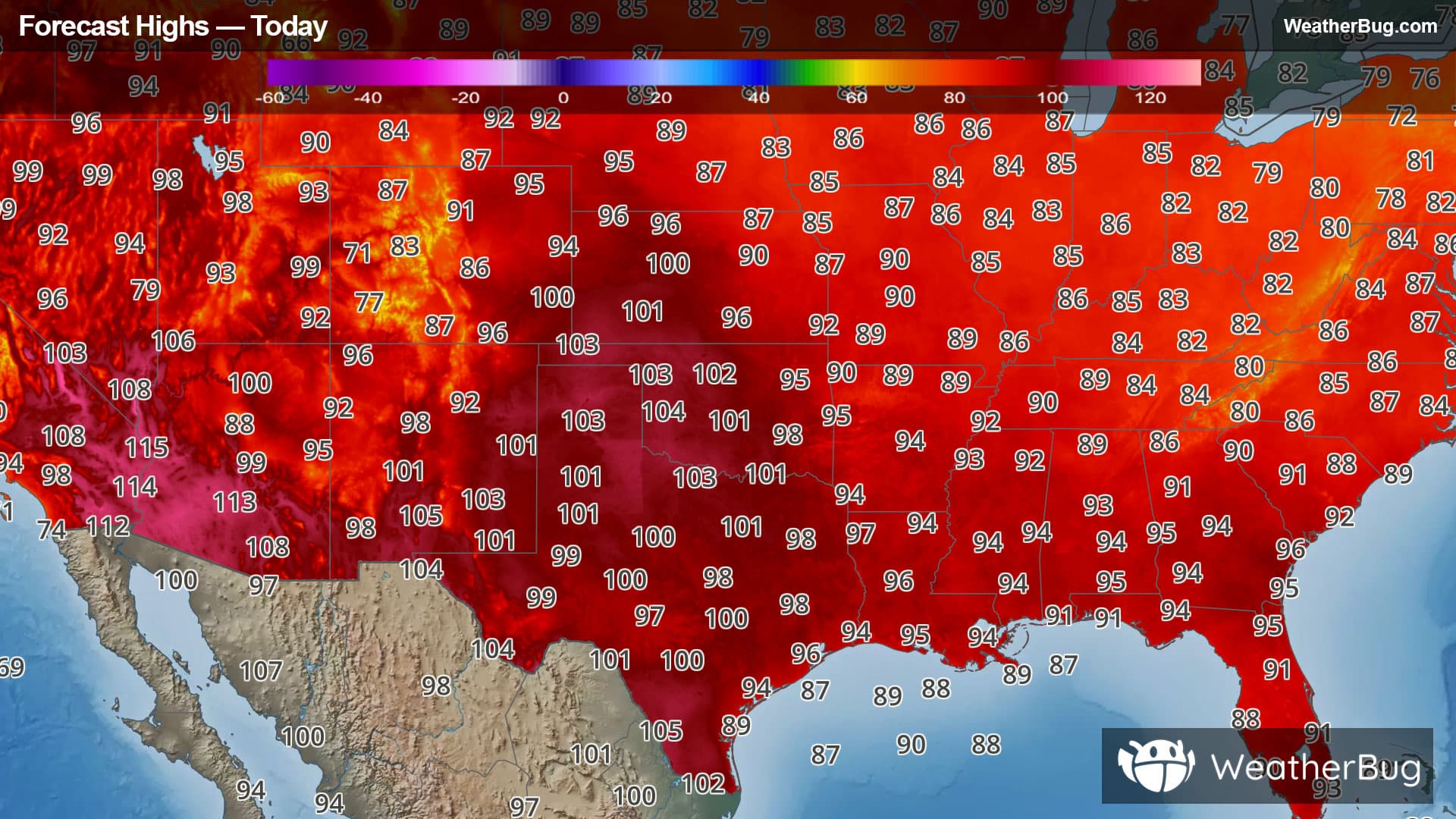
66°FPartly sunny with a chance of showers with a slight chance of thunderstorms. Near steady temperature in the upper 60s. North winds 5 to 10 mph. Chance of rain 40 percent.
Tonight
57°F
Partly cloudy. Patchy fog. Lows in the mid 50s. Northwest winds around 5 mph.
- 74|57°F
 Mostly SunnyHourly details
Day
74°FMostly sunny. Highs in the mid 70s. Northwest winds around 5 mph.
Night
57°F
Mostly clear. Lows in the mid 50s. West winds around 5 mph.
Weekend Weather
- 78|62°FMostly SunnyHourly details
Day
78°FMostly sunny. Highs in the upper 70s. Southwest winds around 5 mph.
Night
62°F
Mostly cloudy. Lows around 60.
- 73|63°F50% Chance of StormsHourly details
Day
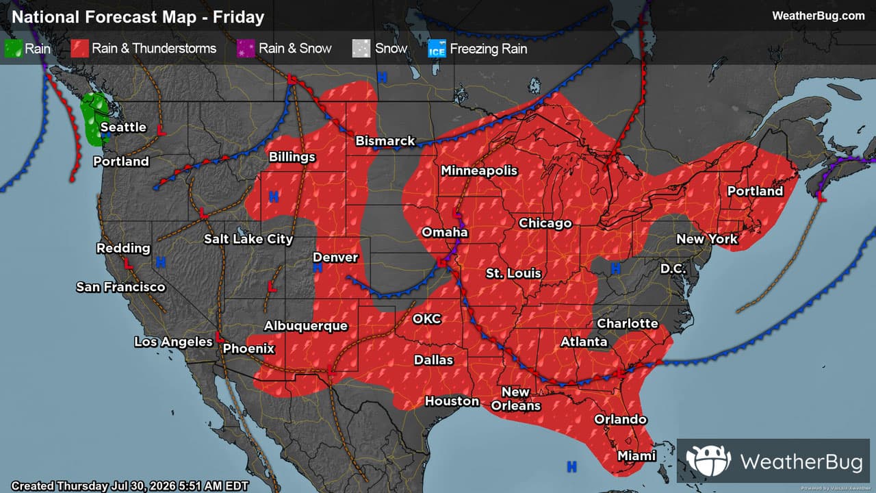
73°FMostly cloudy. A chance of showers and thunderstorms in the afternoon. Highs in the mid 70s. Chance of rain 50 percent.
Night
63°F
A chance of thunderstorms in the evening. Showers. Lows around 60. Chance of rain 80 percent.
- 72|53°F50% Chance of StormsHourly details
Day
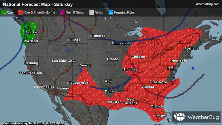
72°FMostly cloudy in the morning, then becoming partly sunny. A chance of showers. A chance of thunderstorms in the afternoon. Highs in the mid 70s. Chance of rain 50 percent.
Night
53°FMostly cloudy with a chance of showers and thunderstorms in the evening, then partly cloudy after midnight. Lows in the mid 50s. Chance of rain 50 percent.
- 75|57°F
 Partly CloudyHourly details
Day
75°FPartly cloudy. Highs in the mid 70s.
Night
57°FPartly cloudy. Lows in the upper 50s.
- 78|64°F
 30% Chance Rain Showers
Day
78°FMostly sunny. A chance of showers in the afternoon. Highs in the upper 70s. Chance of rain 30 percent.
Night
64°F
Partly cloudy with a 40% chance for rain and thunderstorms. Low temperature around 64F. Dew point will be around 62F with an average humidity of 87%. Winds will be 2 mph from the S.
- 80|63°F
 50% Chance of Rain
Day
80°FMostly sunny with a 50% chance for rain and thunderstorms. High temperature around 80F. Dew point will be around 67F with an average humidity of 76%. Winds will be 4 mph from the SW.
Night
63°FMostly clear with a chance of rain. Chance of precipitation 55%. Low temperature around 63F. Dew point will be around 63F with an average humidity of 91%. Winds will be 2 mph from the W.
- 76|61°F40% Chance of Rain
Day
76°FMostly sunny with a 40% chance for rain and thunderstorms. High temperature around 76F. Dew point will be around 64F with an average humidity of 78%. Winds will be 3 mph from the W.
Night
61°FClear with a 40% chance for rain and thunderstorms. Low temperature around 61F. Dew point will be around 60F with an average humidity of 87%. Winds will be 2 mph from the W.
Weekend Weather
- 75|59°F40% Chance of Rain
Day
75°FSunny with a chance of rain. Chance of precipitation 35%. High temperature around 75F. Dew point will be around 61F with an average humidity of 75%. Winds will be 3 mph from the W.
Night
59°FMostly clear with a chance of rain. Chance of precipitation 35%. Low temperature around 59F. Dew point will be around 59F with an average humidity of 89%. Winds will be 1 mph from the W.