10-Day Weather Forecast - Berwyn, IL
Weekend Weather
- 68|66°F
 ThunderstormsHourly details
Today
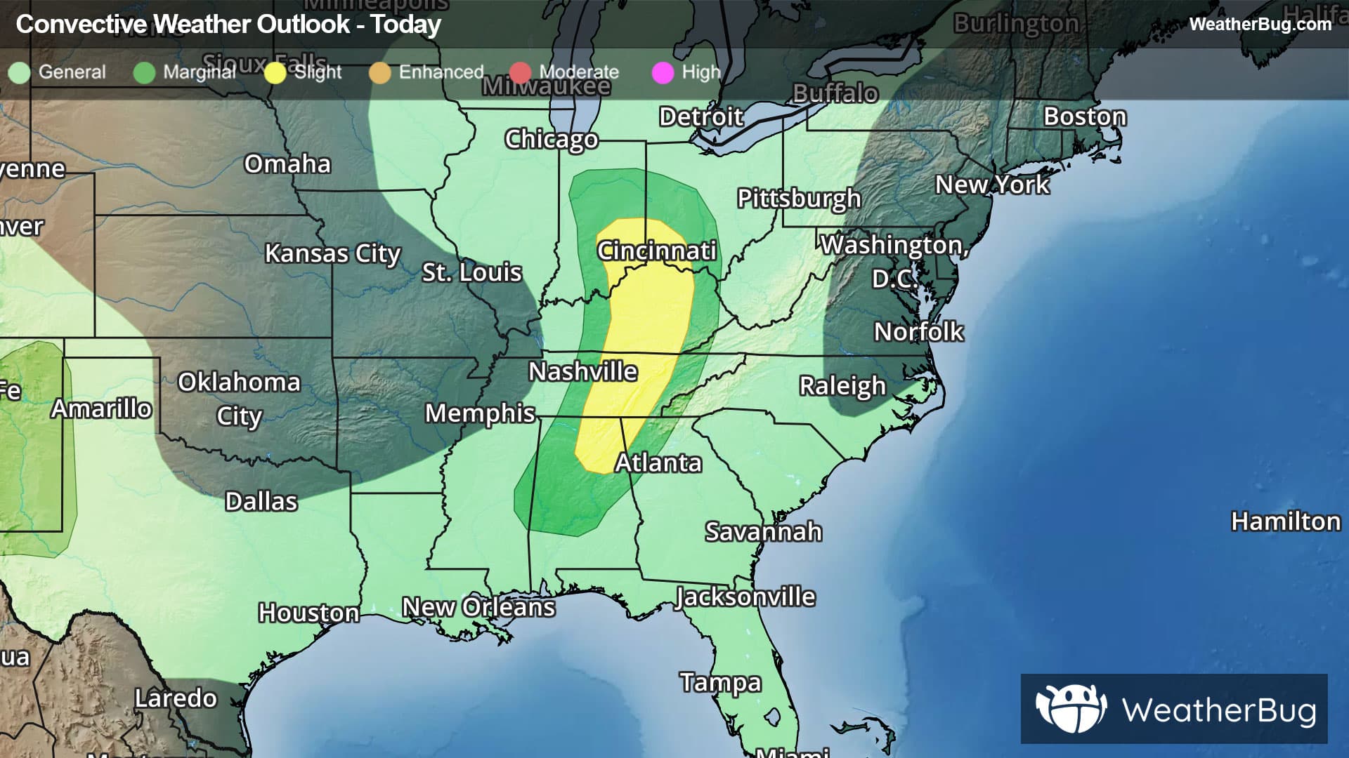
68°FShowers and a chance of thunderstorms. Breezy. Near steady temperature in the lower 70s. Northeast winds 15 to 20 mph with gusts up to 30 mph. Chance of precipitation 90 percent.
Tonight
66°F
Cloudy. A slight chance of thunderstorms early in the evening. A chance of showers until early morning, then a slight chance of showers late. Breezy. Near steady temperature in the upper 60s. Northeast winds 15 to 20 mph with gusts up to 30 mph. Chance of precipitation 50 percent.
- 73|65°F
 Mostly CloudyHourly details
Day
73°FMostly cloudy. A slight chance of showers early in the morning. Highs in the mid 70s. North winds 15 to 20 mph with gusts up to 25 mph. Chance of precipitation 20 percent.
Night
65°F
Partly cloudy in the evening, then clearing. Lows in the mid 60s. North winds 10 to 15 mph with gusts up to 25 mph, becoming northeast 5 to 10 mph after midnight.
- 76|63°F
 Mostly SunnyHourly details
Day
76°FMostly sunny. Highs in the mid 70s. Northeast winds 5 to 10 mph.
Night
63°F
Mostly clear. Lows in the lower 60s.
- 81|67°FMostly SunnyHourly details
Day
81°FMostly sunny. Highs in the lower 80s.
Night
67°FMostly clear in the evening, then becoming partly cloudy. Lows in the mid 60s.
- 81|68°F30% Chance of StormsHourly details
Day
81°FPartly cloudy in the morning, then mostly cloudy with a chance of showers and thunderstorms in the afternoon. Highs in the lower 80s. Chance of precipitation 30 percent.
Night
68°F
Partly cloudy in the evening, then mostly cloudy with a chance of showers after midnight. Lows in the upper 60s. Chance of precipitation 30 percent.
- 82|68°F
 30% Chance Rain ShowersHourly details
Day
82°FMostly cloudy with a chance of showers. Highs in the lower 80s. Chance of precipitation 30 percent.
Night
68°FPartly cloudy in the evening, then becoming mostly cloudy. A chance of showers. Lows in the upper 60s. Chance of precipitation 40 percent.
- 85|69°F
 Partly Cloudy
Day
85°FMostly cloudy in the morning, then becoming partly cloudy. Highs in the lower 80s.
Night
69°F
Partly cloudy with a 30% chance for rain and thunderstorms. Low temperature around 69F. Dew point will be around 68F with an average humidity of 81%. Winds will be 2 mph from the S.
Weekend Weather
- 78|67°F
 30% Chance of Rain
Day
78°FMostly sunny with a 30% chance for rain and thunderstorms. High temperature around 78F. Dew point will be around 67F with an average humidity of 76%. Winds will be 2 mph from the SW.
Night
67°FMostly clear with widely scattered thunderstorms. Chance of storms 25%. Low temperature around 67F. Dew point will be around 66F with an average humidity of 86%. Winds will be 1 mph from the W.
- 78|67°F30% Chance of Rain
Day
78°FSunny with a 30% chance for rain and thunderstorms. High temperature around 78F. Dew point will be around 66F with an average humidity of 74%. Winds will be 1 mph from the SW.
Night
67°FMostly clear with a 30% chance for rain and thunderstorms. Low temperature around 67F. Dew point will be around 65F with an average humidity of 83%. Winds will be 2 mph from the SW.
- 78|67°F30% Chance of Rain
Day
78°FMostly sunny with a 35% chance for rain and thunderstorms. High temperature around 78F. Dew point will be around 67F with an average humidity of 75%. Winds will be 2 mph from the W.
Night
67°F
Clear with widely scattered thunderstorms. Chance of storms 30%. Low temperature around 67F. Dew point will be around 65F with an average humidity of 83%. Winds will be 1 mph from the NW.