10-Day Weather Forecast - Dayton, MT
- |52°F
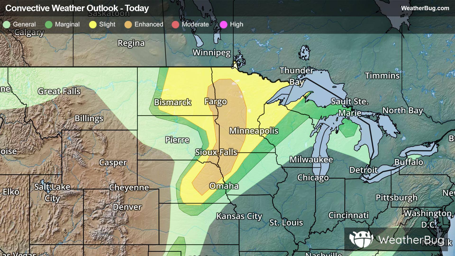
 ThunderstormsHourly details
Tonight
52°FRain showers likely and a chance of thunderstorms in the evening then areas of rain after midnight. Chance of precipitation near 100 percent. Some thunderstorms may produce heavy rainfall. Lows in the mid 40s to lower 50s.
- 64|50°F
 60% Chance of StormsHourly details
Day
64°FA chance of rain in the morning then rain likely and a slight chance of thunderstorms in the afternoon. Chance of precipitation 60 percent. Highs in the mid 60s to lower 70s.
Night
50°FMostly cloudy with a chance of rain showers and a slight chance of thunderstorms in the evening then partly cloudy after midnight. Chance of precipitation 30 percent. Lows in the mid 40s to lower 50s.
- 69|49°F
 Partly CloudyHourly details
Day
69°FPartly cloudy. A 20 percent chance of rain in the afternoon. Highs in the upper 60s to mid 70s.
Night
49°F
Mostly clear. Lows in the 40s to lower 50s.
- 71|54°FPartly CloudyHourly details
Day
71°FPartly cloudy. Highs in the 70s.
Night
54°F
Partly cloudy. Lows in the mid 40s to lower 50s.
- 73|51°FPartly CloudyHourly details
Day
73°FPartly cloudy. A 20 percent chance of showers and thunderstorms in the afternoon. Highs in the 70s.
Night
51°FMostly clear. Lows in the mid 40s to lower 50s.
Weekend Weather
- 76|52°F
 Mostly SunnyHourly details
Day
76°FMostly sunny. Highs in the mid 70s to lower 80s.
Night
52°FMostly clear. Lows in the upper 40s to mid 50s.
- 80|59°FMostly SunnyHourly details
Day
80°FMostly sunny. Highs in the 80s.
Night
59°FPartly cloudy. Lows in the 50s.
- 84|58°FMostly Sunny
Day
84°FMostly sunny. Highs in the 80s.
Night
58°FMostly clear. Low temperature around 58F. Dew point will be around 52F with an average humidity of 60%. Winds will be 1 mph from the SW.
- 82|58°FPartly Cloudy
Day
82°FPartly cloudy. High temperature around 82F. Dew point will be around 53F with an average humidity of 52%. Winds will be 2 mph from the S.
Night
58°F
Clear. Low temperature around 58F. Dew point will be around 52F with an average humidity of 60%. Winds will be 2 mph from the SW.
- 83|57°F
 Sunny
SunnyDay
83°FSunny. High temperature around 83F. Dew point will be around 52F with an average humidity of 50%. Winds will be 3 mph from the SW.
Night
57°FClear. Low temperature around 57F. Dew point will be around 50F with an average humidity of 57%. Winds will be 2 mph from the SW.