10-Day Weather Forecast - Lewisville, IN
- 84|70°F
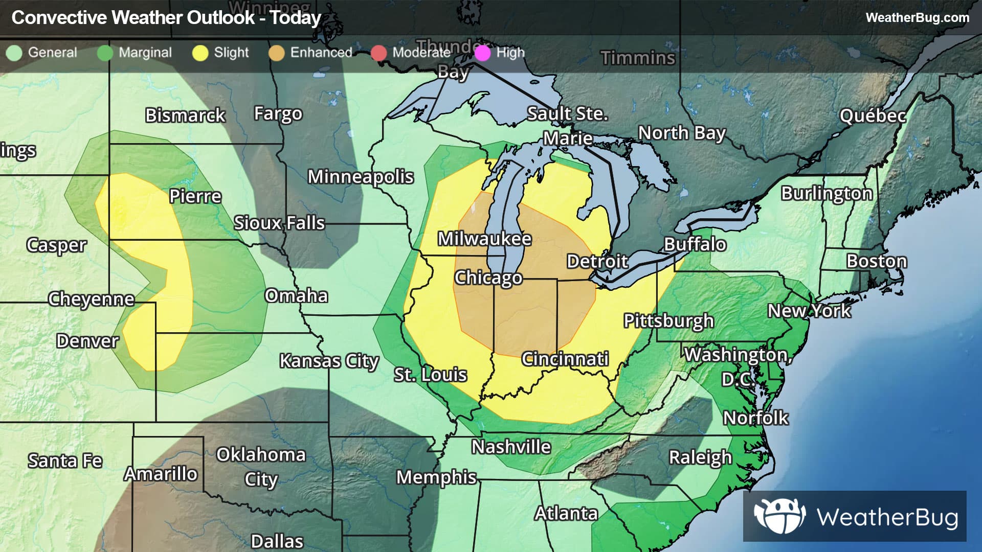
 50% Chance of StormsHourly details
Today
84°FPartly cloudy. Patchy fog early this afternoon. Isolated showers and thunderstorms early this afternoon then scattered showers and thunderstorms late this afternoon. Highs in the upper 80s. Southwest winds 5 to 10 mph. Gusts up to 20 mph late this afternoon. Chance of rain 50 percent.
Tonight
70°F
Partly cloudy with a chance of showers. A chance of thunderstorms through the late overnight then a slight chance of thunderstorms toward daybreak. Humid with lows in the lower 70s. West winds 5 to 10 mph with gusts up to 20 mph. Chance of rain 50 percent.
- 79|63°F
 Partly CloudyHourly details
Day
79°FPartly cloudy. Humid with highs in the lower 80s. Northwest winds around 10 mph with gusts up to 25 mph.
Night
63°F
Partly cloudy through the late overnight then clearing. Cooler with lows in the lower 60s. North winds 5 to 10 mph. Gusts up to 20 mph through the late overnight.
- 77|59°F
 SunnyHourly details
Day
77°FSunny. Highs around 80. North winds 5 to 10 mph.
Night
59°F
Clear. Lows in the upper 50s. Highs in the lower 80s.
- 79|63°FSunnyHourly details
Day
79°FClear. Lows in the upper 50s. Highs in the lower 80s.
Night
63°FMostly clear through the late overnight then becoming partly cloudy. Lows in the lower 60s.
- 81|68°FPartly CloudyHourly details
Day
81°FPartly cloudy with a slight chance of showers. A slight chance of thunderstorms late in the afternoon. Highs in the lower 80s. Chance of rain 20 percent.
Night
68°F
Partly cloudy. A slight chance of showers through the late overnight then a chance of showers toward daybreak. Lows in the mid 60s. Chance of rain 40 percent.
Weekend Weather
- 75|64°F50% Chance of StormsHourly details
Day
75°FPartly cloudy with a chance of showers. A slight chance of thunderstorms late in the afternoon. Highs in the lower 80s. Chance of rain 50 percent.
Night
64°FPartly cloudy with a 20 percent chance of showers. Lows in the mid 60s.
- 77|65°FPartly Cloudy
Day
77°FPartly cloudy. A slight chance of showers and thunderstorms late in the afternoon. Highs in the lower 80s. Chance of rain 20 percent.
Night
65°F
Mostly clear with a 40% chance for rain and thunderstorms. Low temperature around 65F. Dew point will be around 67F with an average humidity of 95%. Winds will be 5 mph from the N.
- 79|66°FSunny
Day
79°FSunny. High temperature around 79F. Dew point will be around 65F with an average humidity of 74%. Winds will be 3 mph from the E.
Night
66°FClear. Low temperature around 66F. Dew point will be around 65F with an average humidity of 83%. Winds will be 4 mph from the SE.
- 81|69°FSunny
Day
81°FSunny with widely scattered thunderstorms. Chance of storms 25%. High temperature around 81F. Dew point will be around 67F with an average humidity of 74%. Winds will be 5 mph from the S.
Night
69°FClear with widely scattered thunderstorms. Chance of storms 30%. Low temperature around 69F. Dew point will be around 69F with an average humidity of 85%. Winds will be 3 mph from the S.
- 82|69°F
 40% Chance of Rain
Day
82°FSunny with a 40% chance for rain and thunderstorms. High temperature around 82F. Dew point will be around 69F with an average humidity of 76%. Winds will be 4 mph from the SW.
Night
69°FMostly clear with a 35% chance for rain and thunderstorms. Low temperature around 69F. Dew point will be around 69F with an average humidity of 85%. Winds will be 1 mph from the W.