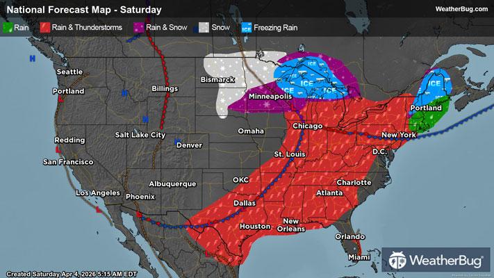
Gusty Thunderstorms Stretch From the Eastern Lakes to the South
Gusty thunderstorms will stretch from the eastern Great Lakes to Texas today.
Read More
Weather Station:Park Place Subdivision
64degrees Fahrenheit
Feels like:64°F
Hi: 65Lo: 37
70% Chance of Light Rain
Hi64°F
Cloudy. A slight chance of thunderstorms early in the morning. Showers in the morning then a slight chance of showers early in the afternoon. Some thunderstorms may produce heavy rainfall early in the morning. Breezy. Highs in the lower 60s. Temperature falling into the lower 50s in the afternoon. Southwest winds 15 to 20 mph with gusts up to 30 mph. Chance of precipitation 90 percent.
Lo36°F
Mostly cloudy and breezy. Lows in the mid 30s. West winds 15 to 20 mph diminishing to 10 to 15 mph after midnight. Gusts up to 30 mph.
26 | Fair
3.4 Low-Medium
Closest strike in the last 30 minutes:696.9 miles
No Lightning Nearby