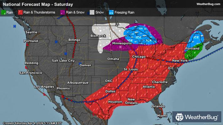
Wiota, WI Weather

As of

Weather Station:Monroe Fire Station #1 (west side)

Open weather station selector modal

1degrees Fahrenheit

Feels like:-20°F

Hi: 10Lo: -1

Mostly Cloudy

Live Weather Radar

Wiota, WI weather radar map

Current Weather Details

Windchill
--
Daily Rain
--
Dew point
--
Monthly Rain
--
Humidity
--
Avg. Wind
--
Pressure
--
Wind Gust
--
Sunrise
7:25 AM
Moon
New
Sunset
4:56 PM
UV Index
1 (Low)

Weather Forecast

  • Tonight

    Lo

    Bitterly cold. Breezy. Mostly cloudy until early morning then becoming partly cloudy. Light snow in the evening then chance of light snow late in the evening. Areas of blowing snow in the late evening and overnight. Snow accumulation up to 1 inch. Total snow accumulation up to 2 inches. Lows around 5 below. West winds 10 to 15 mph shifting to the northwest 15 to 25 mph after midnight. Gusts up to 40 mph. Chance of snow 90 percent. Lowest wind chill readings 18 below to 28 below zero after midnight.

  • Tomorrow

    Hi

    Bitterly cold. Colder. Partly sunny. Areas of blowing snow in the morning. Highs around 3. Northwest winds 10 to 20 mph with gusts to around 35 mph. Lowest wind chill readings 20 below to 30 below zero until late afternoon.

Wiota, WI 10-day weather forecast

AIR QUALITY

21 | Fair

Top Triggers:pm25
Air quality data provided by Ambee
View Today's Air Quality details for Wiota, WI

POLLEN COUNT & ALLERGY FORECAST

0.1 Low

Predominant Pollen:None
View the Pollen forecast details

LIGHTNING MAP

Closest strike in the last 30 minutes:1363.6 miles

No Lightning Nearby

Real-time lightning alerts & live Map