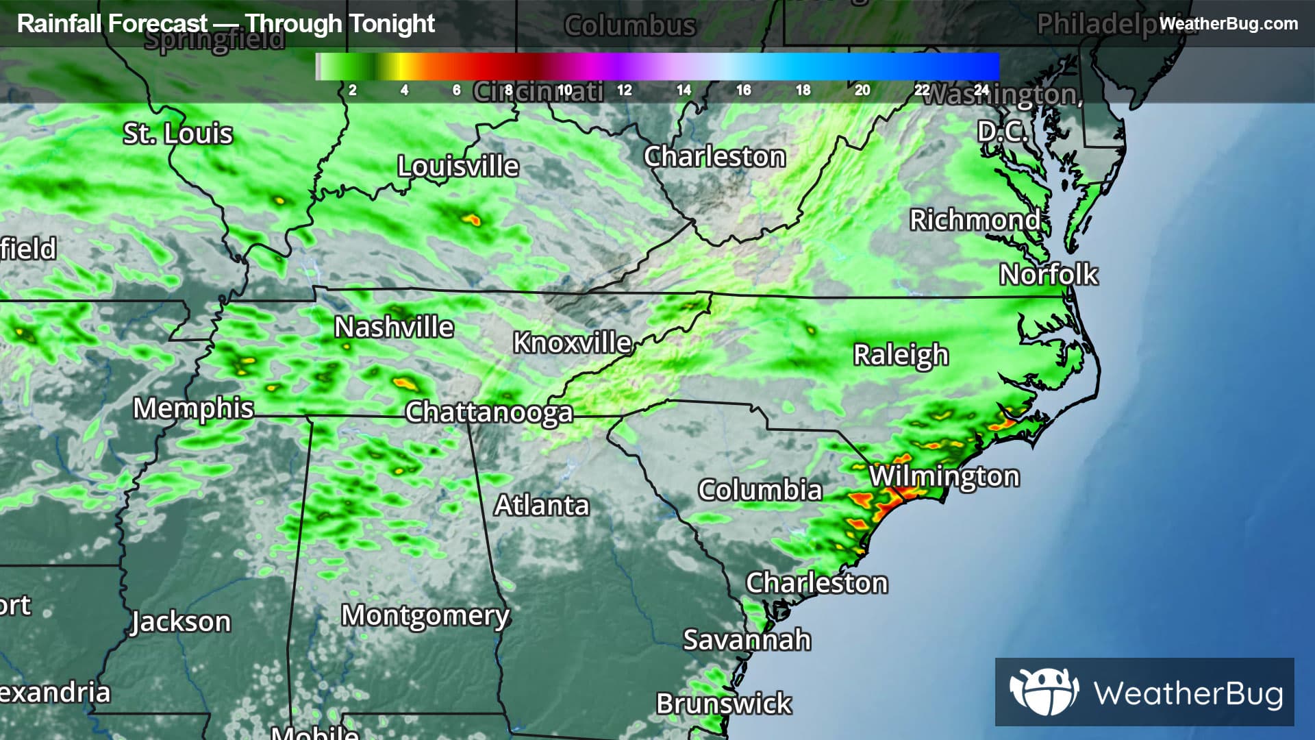
Weather Alerts For Florida, OH
Flood Warning
-Flood Statement National Weather Service Northern Indiana 1051 AM EDT Sat Apr 4 2026 ...The Flood Warning is extended for the following rivers in Indiana... Tippecanoe River above Winamac affecting Pulaski, Carroll and White Counties. ...The Flood Warning continues for the following rivers in Indiana... Ohio... Wabash River near Linn Grove affecting Wells and Adams Counties. Eel River at North Manchester affecting Cass IN, Wabash, Miami, Kosciusko and Whitley Counties. Blanchard River at Ottawa affecting Putnam County. Maumee River at Napoleon affecting Henry County. Maumee River near Defiance affecting Henry and Defiance Counties. Maumee River at Fort Wayne affecting Paulding and Allen IN Counties. Saint Joseph River Ohio below Montpelier affecting Williams County. Saint Joseph River Ohio near St. Joe River Ft. Wayne affecting Allen IN County. Saint Marys River near Decatur affecting Allen IN, Adams and Van Wert Counties. Tippecanoe River near Ora affecting Pulaski County. Saint Joseph River Ohio near Newville affecting Defiance, Allen IN and De Kalb Counties. Tiffin River at Stryker affecting Fulton OH, Defiance and Williams Counties. North Branch Elkhart River at Cosperville affecting Noble County. For the Tippecanoe River...including Ora, Winamac, Norway Dam... Moderate flooding is forecast. For the Wabash River...including Linn Grove, Bluffton IN, Wabash, Logansport...Minor flooding is forecast. For the Eel River...including North Manchester...Minor flooding is forecast. For the Blanchard River...including Ottawa...Minor flooding is forecast. For the Maumee River...including Fort Wayne, Defiance, Napoleon... Minor flooding is forecast. For the Saint Joseph River Ohio...including Montpelier, Newville, St. Joe River Ft. Wayne...Moderate flooding is forecast. For the Saint Marys River...including Decatur, St. Mary's River near Fort Wayne...Minor flooding is forecast. For the Tiffin River...including Stryker...Minor flooding is forecast. For the Elkhart River...including Goshen, Cosperville...Minor flooding is forecast. PRECAUTIONARY/PREPAREDNESS ACTIONS... Motorists should not attempt to drive around barricades or drive cars through flooded areas. Detailed river forecasts and additional information can be found at www.weather.gov/iwx under Rivers and Lakes. The next statement will be issued late tonight at 500 AM EDT. && 1051 AM EDT Sat Apr 4 2026 ...FLOOD WARNING NOW IN EFFECT UNTIL EARLY TUESDAY AFTERNOON... * WHAT...Minor flooding is forecast. * WHERE...Maumee River at Napoleon. * WHEN...Until early Tuesday afternoon. * IMPACTS...At 12.5 feet, Recreational campgrounds near Napoleon begin to flood. * ADDITIONAL DETAILS... - At 11:20 AM EDT Thursday, April 02 the stage was 11.2 feet. - Forecast...The river will rise above flood stage to 12.3 feet this afternoon. It will then fall this evening. It will rise to 12.6 feet tomorrow evening. It will then fall below flood stage early Monday afternoon. - Flood stage is 12.0 feet. - http://www.weather.gov/safety/flood &&
Severe Storm Risk
-There is a Slight Severe Storm Risk for your location. Continue reading for today's outlook from the National Weather Service's Storm Prediction Center. -------------------- National Severe Storm Outlook THERE IS A SLIGHT RISK OF SEVERE THUNDERSTORMS ACROSS THE LOWER GREAT LAKES/OHIO VALLEY SUMMARY Severe storms capable of damaging winds and a tornado risk are expected across parts of the Lower Great Lakes and middle/upper Ohio River Valley, mainly this afternoon through early evening. Other more isolated severe storms may occur across the Tennessee Valley, Lower Mississippi Valley, and eastern part of Texas. Ohio/Eastern Indiana/Lower Michigan to Pennsylvania/New York A shortwave trough over the Upper Midwest early today will continue northeastward toward the upper Great Lakes through tonight. Cyclonically influenced strengthening deep-layer southwesterlies (50+ kt 700 mb) will overspread Indiana/Michigan toward the Lower Great Lakes, atop a steadily moistening/heating warm-sector boundary layer along and north of the Ohio River. This will be ahead of a surface low and cold front, that is considerably augmented by generally weakening thunderstorms and prevalent lingering clouds/outflows through the pre-dawn hours. These residual factors cast uncertainty regarding the magnitude of today's overall potential, but a formidable flow field and guidance-advertised heating/steady diurnal destabilization will still be supportive of at least some severe potential regionally as storms redevelop and intensify this afternoon. This includes damaging wind potential, particularly given the magnitude of low/mid-tropospheric winds and boundary layer mixing, with some tornado threat as well, mainly in vicinity of the triple point/nearby warm front. Overall storm intensities should decrease by mid/late evening, owing to nocturnal boundary-layer influences and the primary upper-level system spreading away from the region. Tennessee Valley/Lower Mississippi Valley/Texas While diminishing in intensity overnight, showers/thunderstorms remain extensive and prevalent from the Mid-South/Ozarks southwestward into North Texas, as a synoptic cold front otherwise continues to progress southeastward across these regions. While details are complexified by considerable cloud cover and lingering storms, multiple corridors of reinvigorating storms should materialize this afternoon where more appreciable cloud breaks/heating occur. Downbursts/locally damaging winds will be the primary severe hazard, but this is currently expected to be on a relatively isolated/episodic basis.