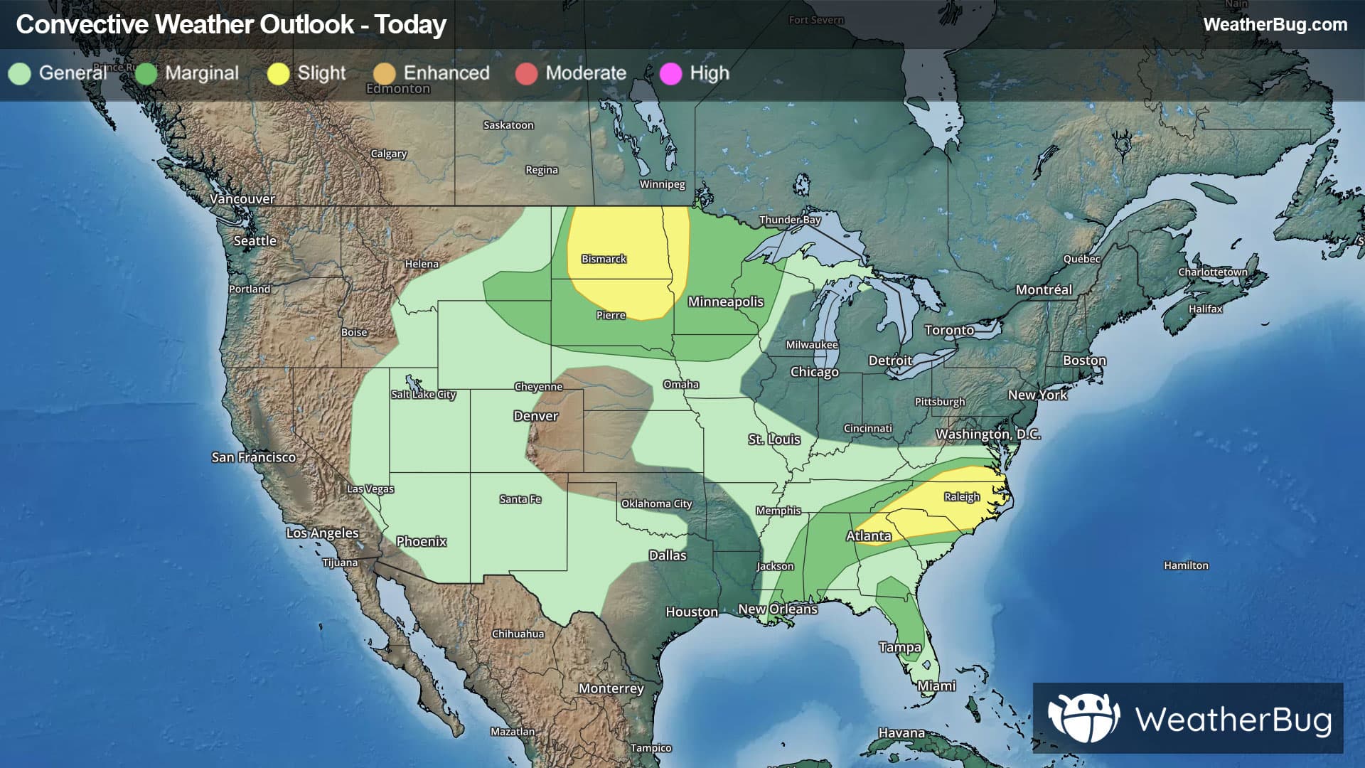
Weather Alerts For Mad River, CA
High Wind Warning
-URGENT - WEATHER MESSAGE National Weather Service Eureka CA 204 PM PST Mon Dec 22 2025 Southwestern Humboldt-Southern Humboldt Interior- Including Shelter Cove, Whitethorn, Briceland, Ettersburg, Pepperwood, Benbow, Garberville, Shively, Kneeland, Petrolia, Alderpoint, Bridgeville, Bull Creek, Dinsmore, and Honeydew 204 PM PST Mon Dec 22 2025 ...HIGH WIND WARNING IN EFFECT FROM 7 PM TUESDAY TO 8 AM PST WEDNESDAY... * WHAT...Southeast winds 15 to 25 mph with gusts up to 70 mph expected. * WHERE...Southern Humboldt. * WHEN...From 7 PM Tuesday to 8 AM PST Wednesday. * IMPACTS...Damaging winds will blow down trees and power lines. Widespread power outages are expected. Travel will be difficult, especially for high profile vehicles. Wind gusts will be particularly strong along windward ridges and exposed coastal headlands. There is an increased risk of tree branches and other debris on roadways. PRECAUTIONARY/PREPAREDNESS ACTIONS... People are urged to secure loose objects that could be blown around or damaged by the wind. Remain in the lower levels of your home during the windstorm, and avoid windows. Watch for falling debris and tree limbs. Use caution if you must drive. &&
Flood Watch
-URGENT - IMMEDIATE BROADCAST REQUESTED Flood Watch National Weather Service Eureka CA 744 AM PST Mon Dec 22 2025 Coastal Del Norte-Del Norte Interior-Northern Humboldt Coast- Southwestern Humboldt-Northern Humboldt Interior-Southern Humboldt Interior-Northern Trinity-Southern Trinity-Mendocino Coast-Northwestern Mendocino Interior-Northeastern Mendocino Interior-Southwestern Mendocino Interior-Southeastern Mendocino Interior-Northern Lake-Southern Lake- 744 AM PST Mon Dec 22 2025 ...FLOOD WATCH IN EFFECT FROM THIS EVENING THROUGH FRIDAY EVENING... * WHAT...Flooding caused by excessive rainfall is possible. * WHERE...Del Norte County, Humboldt County, Trinity County, Mendocino County, and Lake County. * WHEN...From this evening through Friday evening. * IMPACTS...There will be an increased risk of rock and land slides along roadways. Excessive runoff may result in flooding of rivers, creeks, streams, and other low-lying and flood-prone locations. Creeks and streams may rise out of their banks. Flooding may occur in poor drainage and urban areas. Area creeks and streams are running high and could flood with more heavy rain. * ADDITIONAL DETAILS... - Additional rounds of heavy rain are likely again starting tonight and continuing through Friday night. An additional 4-8 inches of total precipitation is possible through Friday. There will be breaks in the heavy precipitation, but heavy rain falling on already saturated ground will promote flooding impacts. Additional precipitation amounts of 4-8 inches are possible through Friday. - http://www.weather.gov/safety/flood PRECAUTIONARY/PREPAREDNESS ACTIONS... You should monitor later forecasts and be alert for possible Flood Warnings. Those living in areas prone to flooding should be prepared to take action should flooding develop. &&