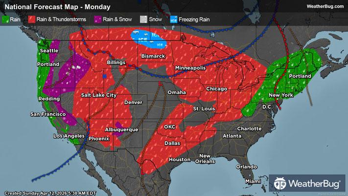
Parade of Storms Hits The Plains, Midwest
The workweek will be filled with chances for severe thunderstorms in the middle of the country.
Read More
Special Weather Statement National Weather Service Baltimore MD/Washington DC 418 AM EDT Mon Apr 13 2026 District of Columbia-Southern Baltimore-Prince Georges- Anne Arundel-Charles-St. Marys-Calvert-Northwest Montgomery- Central and Southeast Montgomery-Northwest Howard- Central and Southeast Howard-Augusta-Rockingham-Shenandoah-Page- Warren-Clarke-Nelson-Albemarle-Greene-Madison-Rappahannock-Orange- Culpeper-Fairfax-Arlington/Falls Church/Alexandria-Stafford- Spotsylvania-King George-Northern Fauquier-Southern Fauquier- Eastern Highland-Western Loudoun-Eastern Loudoun- Northern Virginia Blue Ridge-Central Virginia Blue Ridge- Northwest Prince William- Central and Southeast Prince William/Manassas/Manassas Park- Eastern Pendleton- Including the cities of Washington, Baltimore, Bowie, Suitland-Silver Hill, Clinton, College Park, Greenbelt, Laurel, Camp Springs, Glen Burnie, Annapolis, Severn, South Gate, Severna Park, Arnold, Odenton, St. Charles, Waldorf, Lexington Park, California, Chesapeake Beach, Huntingtown, Dunkirk, North Beach, Lusby, Prince Frederick, Germantown, Damascus, Bethesda, Rockville, Gaithersburg, Silver Spring, Lisbon, Columbia, Ellicott City, Staunton, Waynesboro, Stuarts Draft, Harrisonburg, Strasburg, Woodstock, Mount Jackson, New Market, Luray, Shenandoah, Stanley, Front Royal, Berryville, Lovingston, Charlottesville, Stanardsville, Madison, Orange, Gordonsville, Culpeper, Reston, Herndon, Annandale, Centreville, Chantilly, McLean, Franconia, Arlington, Alexandria, Falls Church, Falmouth, Fredericksburg, Dahlgren, Warrenton, Turnbull, Monterey, Purcellville, Leesburg, Ashburn, Sterling, Big Meadows, Wintergreen, Haymarket, Dale City, Manassas, Woodbridge, Lake Ridge, Montclair, Brandywine, Franklin, Oak Flat, Ruddle, and Sugar Grove 418 AM EDT Mon Apr 13 2026 ...ELEVATED FIRE DANGER FOR MUCH OF CENTRAL AND NORTHERN VIRGINIA, AS WELL AS SOUTH CENTRAL MARYLAND TODAY MONDAY APRIL 13TH... The combination of 10 hour fuel moistures around 8 to 10 percent, relative humidities around 35 percent, and wind gusts of 20 to 30 mph will lead to an increased risk for the rapid spread of wildfires this afternoon. Residents and visitors are urged to properly dispose of cigarette butts, matches, and any other flammable items in appropriate containers. Additionally, exercise caution if operating any equipment that could create sparks and keep vehicles off of dry grass. Most dry grasses, dead leaves, and other tree litter could easily ignite and spread fire quickly. Lastly, remember to obey local burn bans. For more information about wildfire danger, burn restrictions, and wildfire prevention and education, please visit your state forestry or environmental protection website. For West Virginia, visit www.wvforestry.com For Maryland, visit dnr.maryland.gov For Virginia, visit dof.virginia.gov
Pollen Index: 11.6 Pollen Level: high Predominant Pollen: Maple, Elm and Cedar/Juniper. Concentration of pollen grains in the air for Tuesday will be unchanged in the extremely high range. Constant and seasonally normal weather conditions tend to stabilize pollen concentrations in the outdoor air.