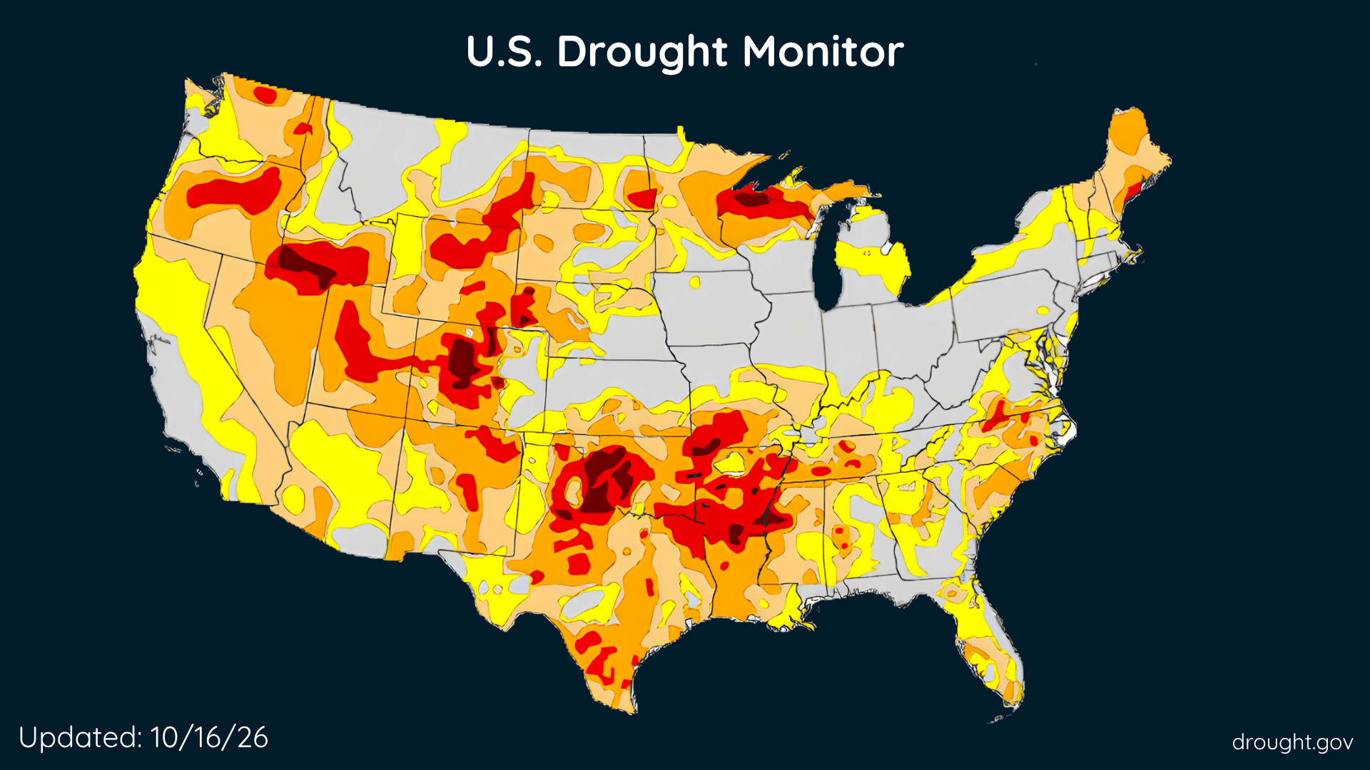
U.S. Drought Improves, Rain Brings Relief, but Some Areas Get Drier
The Southeast and parts of the West made progress this week, while drought deepened across portions of the country’s middle.
# HEADLINE -------------------- FREEZE WATCH REMAINS IN EFFECT FROM LATE SATURDAY NIGHT THROUGH SUNDAY MORNING # DETAILS -------------------- WHAT Sub-freezing temperatures in the upper 20s and low 30s are possible. WHERE Portions of north central and western Maryland, central, northwest, and western Virginia, and eastern and panhandle West Virginia. WHEN From late Saturday night through Sunday morning. IMPACTS Frost and freeze conditions could kill crops, other sensitive vegetation and possibly damage unprotected outdoor plumbing. ISSUED AT Friday, October 16, 2026 at 4:42 PM EDT ISSUED BY National Weather Service Baltimore MD/Washington DC HEADER URGENT - WEATHER MESSAGE # PRECAUTIONARY/PREPAREDNESS ACTIONS -------------------- Take steps now to protect tender plants from the cold. # AREAS AFFECTED -------------------- Frederick, Hampshire, Northern Virginia Blue Ridge, Western Garrett, Augusta, Berkeley, Central and Eastern Allegany, Central Virginia Blue Ridge, Clarke, Eastern Garrett, Eastern Grant, Eastern Highland, Eastern Mineral, Eastern Pendleton, Extreme Western Allegany, Hardy, Jefferson, Morgan, Page, Rockingham, Shenandoah, Warren, Washington, Western Grant, Western Highland, Western Mineral, Western Pendleton Including the cities of Clover Creek, Frenchburg, Ruddle, Frostburg, Petersburg, Howellsville, Springfield, Mountain Lake Park, Oakland, Compton, Mustoe, Moorefield, Waynesboro, Rileyville, Halfway, Piedmont, Gainesboro, Headsville, Grantsville, Paw Paw, Bakerton, Westernport, Arco, Middleway, Woodstock, Antioch, Cedar Grove, Bayard, Franklin, Brake, Wilsonia, Romney, Rawlings, Ingham, McCoole, Bean Settlement, Smith Crossroads, La Vale, Stuarts Draft, Berryville, Shenandoah Junction, Charles Town, Albin, New Hampden, Keyser, Buckton, Kitzmiller, Reynolds, Fisher, Hightown, Brady, Alonzaville, Glen Echo, Front Royal, Fort Ashby, Three Churches, Hawkinstown, McDowell, Luray, Bentonville, Strasburg, Mount Clifton, Hagerstown, Montebello, Clary, Churchville, Winchester, Magnolia, Masonville, Ellerslie, Cabins, Oak Flat, Ridgeville, Possum Trot, Riverton, Points, Landes, Liberty, Millville, Staunton, Sugar Grove, Sirons Mill, Welton, Cedarville, Fairview, Martinsburg, Shady Grove, Christian, Bloomery, Kline Gap, Russelldale, Chester Gap, Purgitsville, Cumberland, Monterey, Linville, Ranson, Mount Jackson, Harrisonburg, Sulphur City, New Creek, Stringtown, Kimball, Skyland, Beechwood, Berkeley Spgs, Spottswood, Wapocomo, Seymourville, Mill Gap, Hancock, McNeill, Brandywine, and Hamburg
# SUMMARY -------------------- SEVERE THUNDERSTORM WATCH 686 REMAINS VALID UNTIL 8 PM EDT THIS EVENING FOR THE FOLLOWING AREAS THE DISTRICT OF COLUMBIA IN MARYLAND THIS WATCH INCLUDES 14 COUNTIES IN CENTRAL MARYLAND ANNE ARUNDEL HOWARD MONTGOMERY PRINCE GEORGES IN NORTH CENTRAL MARYLAND CARROLL FREDERICK WASHINGTON IN NORTHEAST MARYLAND CECIL IN NORTHERN MARYLAND BALTIMORE BALTIMORE CITY HARFORD IN SOUTHERN MARYLAND CALVERT CHARLES ST. MARYS IN VIRGINIA THIS WATCH INCLUDES 25 COUNTIES IN CENTRAL VIRGINIA CITY OF FREDERICKSBURG GREENE KING GEORGE ORANGE SPOTSYLVANIA IN NORTHERN VIRGINIA ARLINGTON CITY OF ALEXANDRIA CITY OF FAIRFAX CITY OF FALLS CHURCH CITY OF MANASSAS CITY OF MANASSAS PARK CULPEPER FAIRFAX FAUQUIER LOUDOUN PRINCE WILLIAM STAFFORD IN NORTHWEST VIRGINIA CITY OF WINCHESTER CLARKE FREDERICK MADISON PAGE RAPPAHANNOCK SHENANDOAH WARREN IN WEST VIRGINIA THIS WATCH INCLUDES 2 COUNTIES IN PANHANDLE WEST VIRGINIA BERKELEY JEFFERSON THIS INCLUDES THE CITIES OF ABERDEEN, ABINGDON, ADAMS MORGAN, ADEN, AIRLIE, ALBIN, ALEXANDRIA, ALONZAVILLE, ALSOP, ANDORA, ANNANDALE, ANNAPOLIS, APPLETON, ARCO, ARKENDALE, ARLINGTON, ARNOLD, BAKERTON, BALLENGER CREEK, BALLSTON, BALTIMORE, BARCROFT, BARKSDALE, BAY VIEW, BENTONVILLE, BERRYVILLE, BETHEL, BETHESDA, BLAKE, BLOOMERY, BOHEMIAS MILLS, BOWIE, BOYDS, BRANTWOOD, BROKENBURG, BROOKFIELD, BROOMES ISLAND, BUCKEYSTOWN, BUCKTON, BURKE, BURR HILL, BYNUM, CALIFORNIA, CALLAWAY, CARDOVA, CATALPA, CATONSVILLE, CEDAR GROVE, CEDARVILLE, CHANTILLY, CHARLES TOWN, CHERRYDALE, CHESAPEAKE BEACH, CHESTER GAP, CLARKSVILLE, CLARY, CLINTON, COLLEGE PARK, COLUMBIA, COMPTON, COUNTRYSIDE, COVE POINT, CULPEPER, DAHLGREN, DALE CITY, DAMERON, DRUM POINT, DULLES INTERNATIONAL AIRPORT, DUNDALK, DUNKIRK, EDGEWOOD, ELDERSBURG, ESSEX, EVERONA, FAIRFAX, FAIRFAX STATION, FAIRVIEW, FALLS CHURCH, FALMOUTH, FELLS POINT, FIVE FORKS, FORDSVILLE, FOUR CORNERS, FREDERICK, FREDERICKSBURG, FRONT ROYAL, GAINESBORO, GAITHERSBURG, GAMBER, GARRISONVILLE, GATEWOOD, GERMANTOWN, GLEEDSVILLE, GLEN BURNIE, GLEN ECHO, GLENDIE, GLENMONT, GREENBELT, HAGERSTOWN, HALFWAY, HAMBURG, HARFORD FURNACE, HAWKINSTOWN, HICKORY, HISTORIC ELLICOTT CITY, HOWELLSVILLE, INDEPENDENT HILL, KIMBALL, LAHORE, LAKE RIDGE, LANGLEY, LEESBURG, LEXINGTON PARK, LONG BEACH, LUCKETTS, LURAY, MADISON MILLS, MADISON RUN, MAGNOLIA, MANASSAS, MANASSAS PARK, MARTINSBURG, MASSAPONAX, MCLEAN, MIDDLEWAY, MILLVILLE, MONTCLAIR, MONTPELIER, MOUNT CLIFTON, MOUNT HARMONY, MOUNT JACKSON, NASONS, OAK GROVE, ORANGE, PARK HEIGHTS, PARK MILLS, PARKVILLE, PARTLOW, PINEY POINT, POST OAK, RANDALLSTOWN, RANSON, RAPIDAN, REAGAN NATIONAL AIRPORT, RESTON, REVA, RIDGE, RIDGEWAY, RILEYVILLE, RIVERCREST, ROLLINS FORK, ROSSLYN, SEVERN, SEVERNA PARK, SHADY GROVE, SHENANDOAH JUNCTION, SHILOH, SILVER SPRING, SIMPSONVILLE, SKYLAND, SOTTERLEY, SOUTH GATE, SPOTSYLVANIA COURT, ST. CHARLES, STERLING PARK, STEVENSBURG, STRASBURG, STRINGTOWN, SUITLAND-SILVER HILL, TANTALLON, TOWSON, TURNBULL, TWYMANS MILL, UNIONVILLE, WALDORF, WARRENTON, WASHINGTON, WESTMINSTER, WIDEWATER, WINCHESTER, WINSTON, WOODBRIDGE, WOODLAWN, WOODSTOCK, AND WOODSTOCK. # DETAILS -------------------- ISSUED AT Friday, October 16, 2026 at 4:37 PM EDT ISSUED BY NATIONAL WEATHER SERVICE BALTIMORE MD/WASHINGTON DC HEADER WATCH COUNTY NOTIFICATION FOR WATCH 686
There is a Marginal Severe Storm Risk for your location. Continue reading for today's outlook from the National Weather Service's Storm Prediction Center. -------------------- National Severe Storm Outlook THERE IS A SLIGHT RISK OF SEVERE THUNDERSTORMS FROM PARTS OF THE MID-ATLANTIC INTO SOUTHERN NEW ENGLAND SUMMARY Thunderstorms capable of producing damaging winds and perhaps a tornado or two are expected across parts of the Mid-Atlantic into southern New England this afternoon and early evening. 20Z Update Only two changes are made to the outlook for this issuance. The first change is to trim the western edge of the slight risk and associated wind and tornado probabilities, to account for the eastward progression of a cold front. The second change is to trim the western edge of the thunder line from much of the Ohio Valley and central Appalachians Mountains.

The Southeast and parts of the West made progress this week, while drought deepened across portions of the country’s middle.