

Tempests Break Out Across Tornado Alley
Scattered severe thunderstorms are set to bully the residents of Tornado Alley today, with new rounds of storms sliding eastward on Monday and Tuesday.
Heading into the latter half of the weekend, the low pressure system currently in the southern Plains will begin its northeastward trek, strengthening along its path. Humid Gulf air will surge through the central Plains, meeting with a burgeoning frontal clash that ignites today’s tempests. As this occurs, tornadic ingredients will align with more organized and intense winds near the ground. A few stronger tornadoes will be possible as supercells and severe thunderstorms cluster across the region this afternoon and evening.
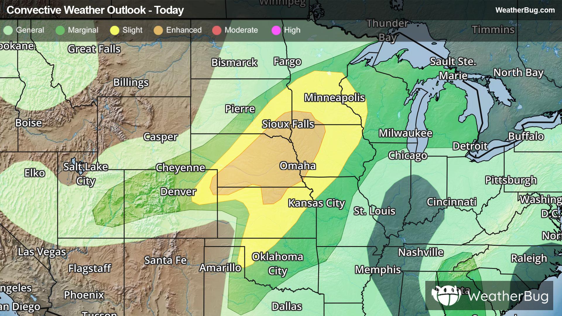
The government’s Storm Prediction Center has posted an Enhanced Risk, or a 3 out of 5 on the severe weather probability scale, over parts of northeastern Colorado and northern Kansas through southwestern Minnesota today, threatening folks residing in Sioux Falls, S.D., Sioux City, Iowa, and Omaha and Lincoln, Neb. Here, widely scattered damaging winds and large hailstorms are expected, likely spawning hailstones of 2 to 4 inches in diameter, damaging winds reaching upward of 75 mph, and isolated, possibly strong, tornadoes.
A Slight Risk, or a 2 out of 5 on the severe weather probability scale, also spans from southern Minnesota and western Wisconsin southwestward into parts of Oklahoma and the Texas Panhandle, containing St. Paul and Minneapolis, Minn., Des Moines, Iowa, and Wichita and Topeka, Kan. More isolated severe thunderstorms are expected here, with similarly large hail, damaging winds, and a few tornadoes.
Entering the workweek, the outbreak is only expected to expand and intensify as the low pressure system's cold front fully organizes. Ahead of and along both the eastward-sweeping front as well as a sharp humidity gradient in the southern Plains, many dangerous supercells, and later, severe thunderstorm lines, will ignite across Tornado Alley all the way from Texas through Michigan.
A rare Moderate Risk, or a 4 out of 5 on the severe weather probability scale, has been issued for northeastern Kansas and far southeastern Nebraska, including Topeka, Manhattan, Emporia, and Lawrence, Kan. This area will be prone to scattered to numerous severe thunderstorms capable of hail of softball size or larger, damaging winds up to and exceeding 75 mph, or isolated and intense tornadic supercells from the afternoon into the overnight hours.
Potent severe weather will still be prevalent under an Enhanced Risk that covers ground from north-central Oklahoma through central Iowa, further encompassed by a vast Slight Risk that stretches from north-central Texas through much of Michigan. Cities that should remain weather-aware on Monday include, but are not limited to, Marquette, Mich., Milwaukee and Madison, Wis., Chicago, Des Moines, Iowa, Omaha, Neb., Kansas City, Kan., Oklahoma City, Okla., and Wichita Falls, Texas.
Tuesday will continue to see storms develop with and ahead of the cold front, rushing over the Great Lakes, the Lower Ohio Valley, and the Mid-South. A Slight Risk has already been posted from north-central Texas through the Great Lakes, with Dallas, Chicago, Detroit, Indianapolis, Memphis, Tenn., and Cleveland, Ohio, all at risk.
Make sure to know the difference between a watch and a warning should they be issued. A watch means that conditions are favorable for severe weather to occur, and to be on alert for any rapidly changing conditions. A warning means that severe weather is imminent, and you should act fast to remain safe.
The best way to remain safe is to stay prepared and informed about your local weather. Have a severe weather kit packed with a battery-operated radio, water, and non-perishable food items should you be without power for long periods of time. Also, check the WeatherBug app frequently for any updates on today’s severe weather. Remember, “When Thunder Roars, Go Indoors!”