
Weekend Weather Preview
A battle of seasons is in store for the U.S. this weekend as a potent cold front brings cold, winter-like weather to parts of the West. Hot, stormy weather is in the forecast elsewhere.
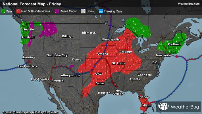
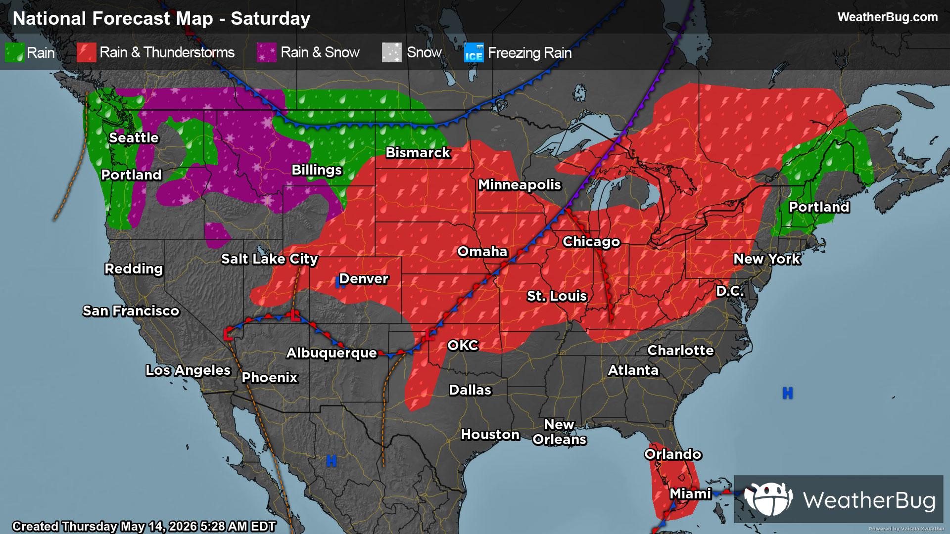
Saturday
A stationary front will be draped over much of the U.S. on Saturday. This will result in precipitation along the front from the Northeast and Lower Midwest into the Rockies. Southerly winds south of the front will also help transport some moisture into the southern Plains and Lower Mississippi Valley. Expect rain and thunderstorms for all these spots. However, some of the tallest peaks in the central and southern Rockies could end up with some wet snow or a rain/snow mix.
Across the Lower Midwest and central/southern High Plains, there will be the potential for thunderstorms to become strong to severe. Severe storms will be capable of producing large to very large up to the size of baseball, damaging winds and perhaps even a strong tornado.
At the same time, a new Pacific storm system will push farther into the Northwest. There will be a good chance of precipitation throughout the Pacific Northwest into the northern Rockies. Coastal areas and lower elevations will be mild enough for just rain. However, temperatures will be cold enough for some snow or a rain/snow mix throughout parts of the Cascades and the higher portions of the northern Rockies.
Besides a few showers or storms in Florida, much of the Eastern Seaboard will be dry for the start of the weekend. California into the Great Basin and the Upper Midwest will also see largely dry, quiet weather.
The Pacific Northwest and northern Rockies will be the coldest spot on Saturday, with temperatures generally in the 40s and 50s. The higher elevations could only see 30s, while the lowest elevations might record a few lower 60s. The tallest peaks in the central and southern Rockies will also report 50s. Expect 60s and 70s for northern California, the Great Basin and the rest of the Rockies into the Upper Midwest and Northeast. Eighties will cover much of California into the Southwest as well as the Lower Midwest, Mid-Atlantic and Southeast. Hot 90s and 100s will be found in the deserts of southern California, southern Nevada and southern Arizona as well as the southern Plains.
Sunday
The large Pacific storm system in the Northwest will strengthen over the western half of the U.S. on Sunday. This will bring plenty of moisture to much of the Western and Central U.S. It will be cold enough through the higher elevations in the Mountain West for wet snow or a rain/snow mix. Otherwise, rain and thunderstorms will soak the rest of the Northwest, Great Basin, Rockies, Plains and Mississippi Valley.
Like Saturday, severe weather will be likely throughout much of the Midwest. Thunderstorms will once again be capable of producing large to very large hail, destructive winds and tornadoes. There will also continue to be the possibility of a strong tornado or two. Slow-moving, repeated rounds of moderate to heavy rain could also develop, leading to localized flooding. If you do approach a flooded roadway, remember that it is always better to “Turn Around, Don’t Drown!”
A persistent south to southwest wind ahead of this system will also continue to transport some moisture from the Gulf northward into the Eastern U.S. This could lead to a few showers and thunderstorms in the Ohio Valley, Mid-Atlantic and Southeast, best chance in the afternoon and evening. There could also be a few early rain showers in southern New England.
Looking for dry weather? You will have to head to California and the Southwest thanks to high pressure settled overhead.
The Mountain West and far northern Plains will be the coldest spot on Sunday. Expect mainly 40s and 50s here, but the highest elevations and areas closer to the U.S.-Canada border could struggle to get out of the 20s and 30s. The lowest elevations could also see the mercury climb into the lower 60s. Milder 60s and 70s are expected for central California and the lower elevations of the Mountain West into the Upper Midwest and Northeast will see 60s and 70s. Eighties and 90s cover the Desert Southwest, the Lower Midwest, Mid-Atlantic and Southeast. Several spots in the southern Plains will report triple-digit heat.