Weekend Weather Preview
Multiple weather systems impact the U.S. this weekend, allowing wet conditions to dry up for some and persist for others.
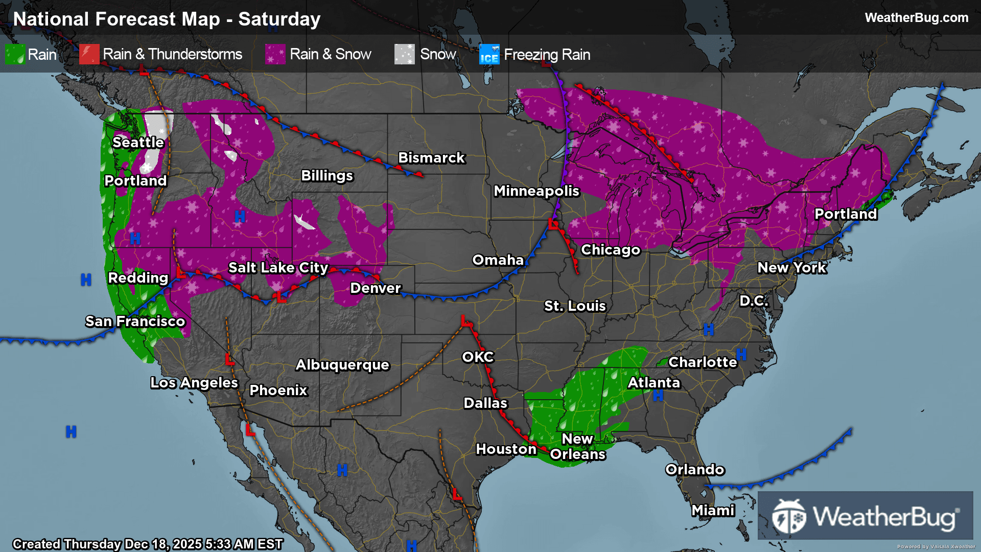
Saturday
In the Northeast, a rain/snow mix will continue along Maine, New Hampshire, Vermont, New York, and Pennsylvania. Northeastern coastal regions will be clear and dry, and high pressure will allow most of the Mid-Atlantic to be dry and clear as well.
In the Southeast, high pressure continues along the Atlantic coast through Florida. Some rain showers will occur through the Tennessee Valley into the Deep South, bringing wet conditions into the weekend. Texas will be primarily dry, with the Central Plains escaping rain as well.
The Midwest will be primarily dry, with the states bordering the Great Lakes seeing a mix of rain and snow. Any snow that will appear will primarily just be snow flurries in the air, or light snow showers. The remainder of the Midwest escaped a wet weekend, with dry conditions persisting.
The Mountain West will continue to see moisture as it comes off an atmospheric river in the Northwest. Rain and snow will dominate the area, with snow primarily being segregated to higher mountain peaks.
In the Northwest, consistent and persistent moisture continues, bringing snow to the Northern Cascades, a rain/snow mix to mountainous foothills, and rain to coastal areas and valleys. This moisture will continue to stretch from Washington to halfway through California.
In contrast with moisture northward, Southern California and the Desert Southwest will continue to see dry conditions throughout the weekend.
Chilly temperatures will dominate north Michigan, North Dakota, and the northeast corner of Montana, as they will hover within the single digits on Saturday. Temperatures will be within the 20s for higher elevated areas in New England and Maine, the area surrounding Lake Superior, and higher elevations in the Rockies.
Temperatures will be in the 30s and 40s among the remainder of New England, the Great Lakes, upper Great Plains, lowland areas within the Rockies, and most of the Pacific Northwest. The coastal areas in the Northwest will be in the 50s, as well as California’s Central Valley, lowland areas of the Great Basin, the Central Plains, and most of the Mid-Atlantic.
Areas such as the Southeast and Southern California will be in the 60s and low 70s, with the Desert Southwest, Texas, and southern Florida seeing higher temperatures in the high 70s and low 80s.
Sunday
A weakening low pressure system will drift across southeastern Canada for the end of the weekend. There is not a huge amount of moisture associated with this low pressure, but flurries or light snow showers will be possible across the Great Lakes and Northeast. Persistent northwesterly winds will also ramp up on Sunday, which could cause snow to be enhanced from the lake-effect. The best chance for snow will be in the morning and afternoon, but there could be lingering snow into the evening.
A surge of moisture from the Gulf will combine with a weather disturbance over the Deep South. Isolated to scattered showers and thunderstorms will be possible as a result. While possible throughout the day, the best chance for showers and storms will be from late morning into the early evening.
Then, on the opposite side of the nation, an upper-level weather system will be strengthening off the West Coast. This weather system will transport plenty of tropical moisture along an atmospheric river into the Northwest. Precipitation will become increasingly likely from southwest-to-northeast throughout the day, starting first in northern California and then spreading into the northern Rockies.
Rain is expected across most of northern California as well as western Washington and western Oregon. Things get more complicated farther inland. Much of the interior Northwest and Great Basin will just see rain or a rain/snow mix. Higher elevations could see some wet snow though at times. It will be just snow for the Cascades, the northern Sierra Nevada and the northern Rockies.
However, all of these areas will see impacts from this system. Heavy rain will be a concern for the coast and lower elevations. With the soil already being saturated, flooding will be a concern, especially near rivers, creeks and streams as well as other low-lying and more flood prone areas. With the potential for moderate to heavy snowfall, roads will likely turn slick, icy and snow-packed, especially over the tallest passes. Gusty winds could also lead to some areas of blowing and drifting snow.
High pressure will keep the weather dry and quiet across southern California into the Southwest along with the rest of the Midwest, Southeast and Mid-Atlantic.
The coldest spots on Sunday will be the Upper Mississippi Valley and Great Lakes, with temperatures only reaching single digits and teens. Expect 20s and 30s for the far northern Plains, Ohio Valley and interior Northeast as well as the higher elevations of the Mountain West. Forties and 50s will be in store for the lower elevations of the Mountain West, the rest of the northern and central Plains, Tennessee Valley, Mid-Atlantic and southern New England. Much of southern California and Desert Southwest into the southern Plains and Southeast will report highs in the 60s and 70s, with isolated 80s possible for the typical warm spots of the Desert Southwest, southern Texas and southern Florida.