10-Day Weather Forecast - Sioux Falls, SD
- 54|27°F70% Chance Frozen MixHourly details
Today
54°FMostly cloudy with probable rain-snow mix. Chance of precipitation 65%. High temperature around 54F. Dew point will be around 24F with an average humidity of 63%. Winds will be 15 mph from the S.
Tonight
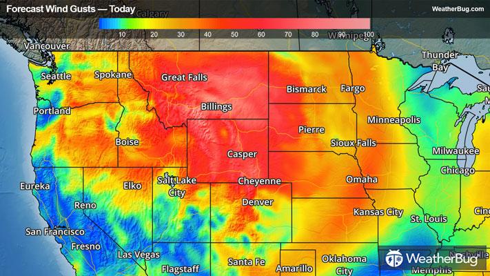
27°FMostly cloudy with a chance of rain this evening then partly cloudy after midnight. Very windy with lows in the mid 20s. Northwest winds 30 to 40 mph with gusts up to 65 mph. Chance of rain 50 percent.
- 37|27°FWindyHourly details
Day
37°FMostly sunny and windy. Much cooler with highs in the upper 30s. Northwest winds 20 to 30 mph with gusts up to 40 mph diminishing to 15 to 20 mph in the afternoon.
Night
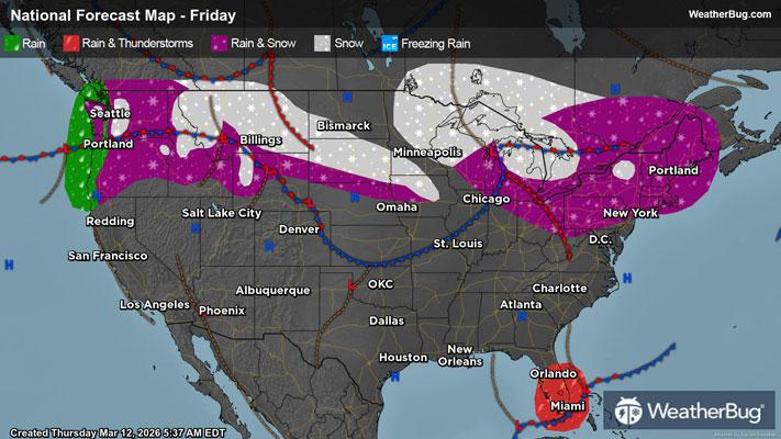
27°FCloudy. A chance of snow in the evening then snow likely after midnight. Snow accumulation around an inch possible. Lows in the mid 20s. Northeast winds 5 to 10 mph becoming east after midnight. Chance of snow 70 percent.
Weekend Weather
- 39|27°F40% Chance Frozen MixHourly details
Day
39°FCloudy. A slight chance of snow in the morning then a chance of snow and rain in the afternoon. Little or no additional snow accumulation. Highs in the upper 30s. East winds 15 to 20 mph. Chance of precipitation 40 percent.
Night
27°FA slight chance of rain. Snow. Patchy blowing snow in the evening. Blowing snow after midnight. Snow may be heavy at times after midnight with visibility one quarter mile or less at times. Moderate snow accumulation. Breezy with lows in the lower 20s. East winds 15 to 25 mph. Gusts up to 40 mph after midnight. Chance of precipitation near 100 percent.
- 28|3°FSnowHourly details
Day
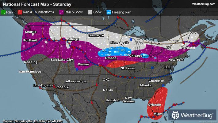
28°FSnow mainly in the morning. Blowing snow. Visibility one quarter mile or less at times in the morning. Additional moderate snow accumulation. Windy cooler. Near steady temperature in the lower 20s. Temperature falling into the lower 20s in the afternoon. Chance of snow near 100 percent.
Night
3°FPartly cloudy with a chance of snow in the evening then mostly clear after midnight. Patchy blowing snow. Windy and much colder with lows around zero. Chance of snow 40 percent. Wind chill values as low as 25 below.
- 13|6°FSunnyHourly details
Day
13°FSunny colder with highs 10 to 15. Wind chill values as low as 25 below.
Night
6°FPartly cloudy in the evening then becoming mostly cloudy. Cold with lows around zero. Wind chill values as low as 10 below.
- 33|32°F40% Chance of SnowHourly details
Day
33°FMostly cloudy. A slight chance of snow in the morning then a chance of snow in the afternoon. Not as cool with highs in the mid 20s. Chance of snow 40 percent. Wind chill values as low as 15 below in the morning.
Night
32°FMostly cloudy. A slight chance of snow in the evening. Not as cool with lows 15 to 20. Chance of snow 20 percent.
- 48|38°FPartly Sunny
Day
48°FMostly cloudy in the morning then becoming partly sunny. Not as cool with highs in the lower 40s.
Night
38°FMostly cloudy in the evening then becoming partly cloudy. Not as cool with lows in the upper 20s.
- 58|41°FMostly Sunny
Day
58°FMostly sunny. Not as cool with highs in the mid 50s.
Night
41°FPartly cloudy. Low temperature around 41F. Dew point will be around 38F with an average humidity of 72%. Winds will be 2 mph from the S.
- 61|44°FPartly Cloudy
Day
61°FPartly cloudy. High temperature around 61F. Dew point will be around 39F with an average humidity of 62%. Winds will be 4 mph from the W.
Night
44°FPartly cloudy. Low temperature around 44F. Dew point will be around 38F with an average humidity of 60%. Winds will be 2 mph from the W.
Weekend Weather
- 54|36°FPartly Cloudy
Day
54°FPartly cloudy. High temperature around 54F. Dew point will be around 36F with an average humidity of 60%. Winds will be 4 mph from the N.
Night
36°FMostly clear. Low temperature around 36F. Dew point will be around 31F with an average humidity of 61%. Winds will be 6 mph from the E.