10-Day Weather Forecast - Apgar, MT
- 58|40°F
 Mostly CloudyHourly details
Today
58°FMostly cloudy. High temperature around 58F. Dew point will be around 37F with an average humidity of 57%. Winds will be 1 mph from the SW.
Tonight
40°F
Partly cloudy early in the evening then becoming mostly cloudy. Lows in the mid 30s to lower 40s.
- 62|42°F
 Partly CloudyHourly details
Day
62°FPartly cloudy. Highs in the 60s.
Night
42°F
Mostly cloudy in the evening then clearing. Lows in the upper 30s to mid 40s.
Weekend Weather
- 69|45°FPartly CloudyHourly details
Day
69°FPartly cloudy. Highs in the mid 60s to lower 70s. Southwest winds to 15 mph.
Night
45°F
Mostly clear. Lows in the 40s. Southwest winds to 15 mph.
- 72|46°F
 Mostly SunnyHourly details
Day
72°FMostly sunny. Highs in the mid 60s to lower 70s.
Night
46°FPartly cloudy. Lows in the 40s.
- 75|47°FPartly CloudyHourly details
Day
75°FPartly cloudy. Highs in the mid 60s to lower 70s.
Night
47°F
Mostly cloudy with a 40 percent chance of rain. Lows in the 40s.
- 64|45°F
 50% Chance of RainHourly details
Day
64°FMostly cloudy with a 50 percent chance of rain. Highs in the upper 50s to mid 60s.
Night
45°FMostly cloudy with a 50 percent chance of rain. Lows in the 40s.
- 59|42°F
 50% Chance of Storms
Day
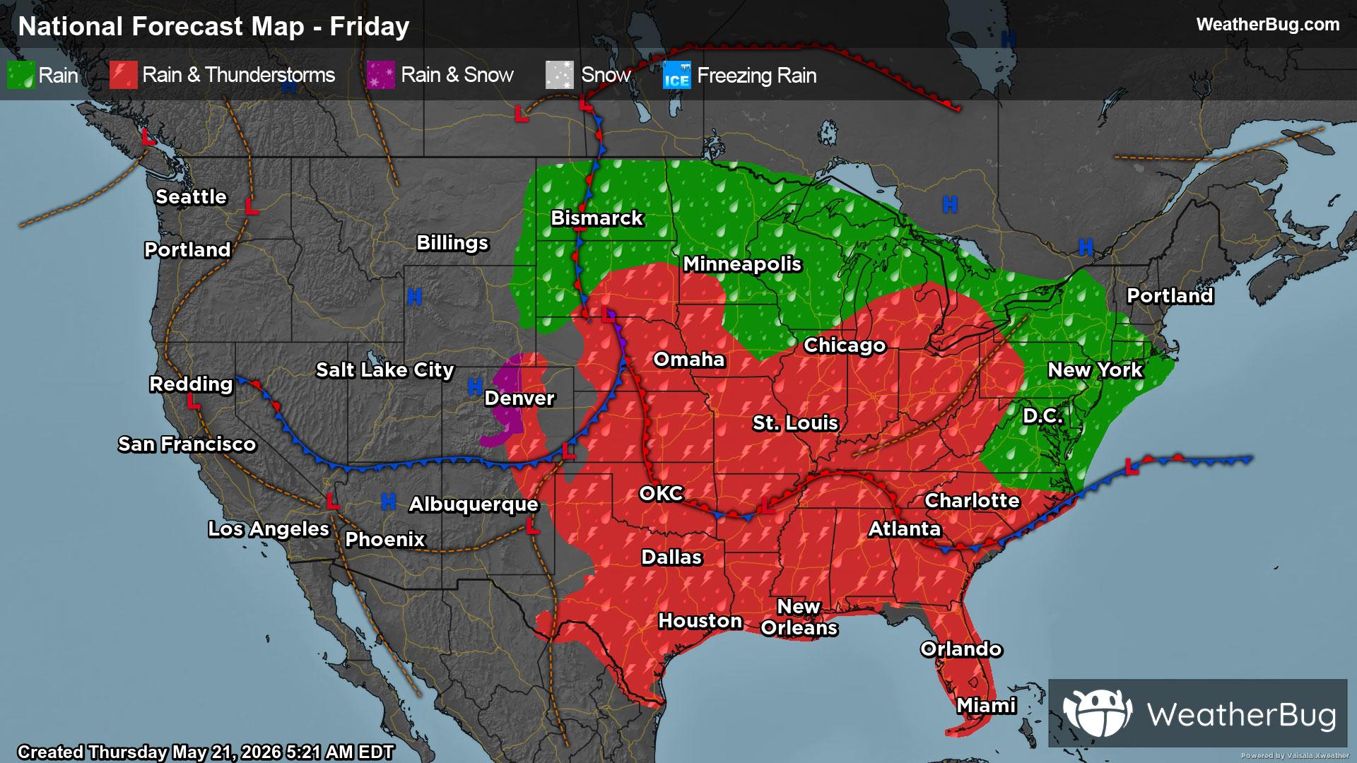
59°FMostly cloudy. A chance of rain in the morning then chance of rain showers and a slight chance of thunderstorms in the afternoon. Chance of precipitation 50 percent. Highs in the upper 50s to mid 60s.
Night
42°FMostly cloudy with a 30 percent chance of rain. Lows in the 40s.
- 64|41°F30% Chance of Rain
Day
64°FMostly cloudy with a 30 percent chance of rain. Highs in the upper 50s to mid 60s.
Night
41°FPartly cloudy with a slight chance of rain. Chance of precipitation 25%. Low temperature around 41F. Dew point will be around 42F with an average humidity of 78%. Winds will be 2 mph from the SW.
- 66|42°F30% Chance of Rain
Day
66°FSunny with a slight chance of rain. Chance of precipitation 30%. High temperature around 66F. Dew point will be around 41F with an average humidity of 60%. Winds will be 3 mph from the SW.
Night
42°FClear with a slight chance of rain. Chance of precipitation 25%. Low temperature around 42F. Dew point will be around 42F with an average humidity of 72%. Winds will be 2 mph from the SW.
Weekend Weather
- 71|44°F
 Sunny
SunnyDay
71°FSunny. High temperature around 71F. Dew point will be around 42F with an average humidity of 54%. Winds will be 2 mph from the SW.
Night
44°F
Clear. Low temperature around 44F. Dew point will be around 44F with an average humidity of 69%. Winds will be 2 mph from the NE.