10-Day Weather Forecast - Bingham, IL
- 79|69°F
 ThunderstormsHourly details
Today
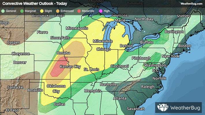
79°FShowers likely with a chance of thunderstorms this morning then showers and thunderstorms this afternoon. Highs in the mid 70s. South winds 15 to 20 mph with gusts up to 30 mph. Chance of rain 90 percent.
Tonight
69°F
Mostly cloudy with a chance of showers and thunderstorms in the evening then partly cloudy after midnight. Lows in the upper 60s. South winds 10 to 15 mph with gusts up to 25 mph. Chance of rain 50 percent.
- 77|58°FThunderstormsHourly details
Day
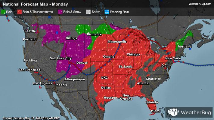
77°FShowers likely with a chance of thunderstorms in the morning then showers with thunderstorms likely in the afternoon. Highs in the lower 80s. Temperature falling into the upper 70s in the afternoon. Southwest winds 15 to 20 mph. Chance of rain near 100 percent.
Night
58°FShowers with a chance of thunderstorms in the evening then a chance of showers after midnight. Cooler with lows in the mid 50s. Northwest winds 5 to 10 mph. Chance of rain near 100 percent.
- 67|51°F
 Partly SunnyHourly details
Day
67°FMostly cloudy in the morning then becoming partly sunny. Much cooler with highs in the upper 60s. North winds 5 to 10 mph.
Night
51°F
Mostly cloudy. Lows in the upper 40s.
- 68|57°F
 Mostly SunnyHourly details
Day
68°FMostly sunny. Highs in the lower 70s.
Night
57°FMostly cloudy. A slight chance of showers after midnight. Lows in the mid 50s. Chance of rain 20 percent.
- 69|60°F50% Chance of StormsHourly details
Day
69°FMostly cloudy with a chance of showers with a slight chance of thunderstorms. Highs in the lower 70s. Lows in the upper 50s. Chance of rain 50 percent.
Night
60°FMostly cloudy with a chance of showers with a slight chance of thunderstorms. Highs in the lower 70s. Lows in the upper 50s. Chance of rain 50 percent.
Weekend Weather
- 76|62°F40% Chance of StormsHourly details
Day
76°FPartly sunny with a slight chance of thunderstorms. A chance of showers mainly in the morning. Highs in the upper 70s. Chance of rain 40 percent.
Night
62°F
Partly cloudy. Lows around 60. Highs in the lower 80s.
- 80|65°FPartly Cloudy
Day
80°FPartly cloudy. Lows around 60. Highs in the lower 80s.
Night
65°F
Partly cloudy with a slight chance of rain. Chance of precipitation 30%. Low temperature around 65F. Dew point will be around 63F with an average humidity of 79%. Winds will be 3 mph from the SE.
- 79|66°F
 40% Chance of Rain
Day
79°FMostly cloudy with a 40% chance for rain and thunderstorms. High temperature around 79F. Dew point will be around 64F with an average humidity of 72%. Winds will be 6 mph from the S.
Night
66°FPartly cloudy with a 40% chance for rain and thunderstorms. Low temperature around 66F. Dew point will be around 64F with an average humidity of 80%. Winds will be 4 mph from the S.
- 80|66°F50% Chance of Rain
Day
80°FPartly cloudy with a chance of rain. Chance of precipitation 45%. High temperature around 80F. Dew point will be around 64F with an average humidity of 71%. Winds will be 4 mph from the SW.
Night
66°FPartly cloudy with a chance of rain. Chance of precipitation 45%. Low temperature around 66F. Dew point will be around 64F with an average humidity of 77%. Winds will be 2 mph from the S.
- 82|67°F60% Chance of Rain
Day
82°FPartly cloudy with a chance of rain. Chance of precipitation 60%. High temperature around 82F. Dew point will be around 64F with an average humidity of 66%. Winds will be 2 mph from the S.
Night
67°FPartly cloudy with a slight chance of rain. Chance of precipitation 30%. Low temperature around 67F. Dew point will be around 63F with an average humidity of 74%. Winds will be 2 mph from the S.