10-Day Weather Forecast - Blaine, IL
- |44°F80% Chance of StormsHourly details
Tonight
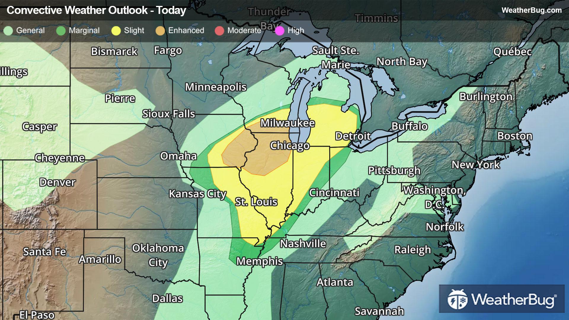
44°FMostly cloudy. Showers and numerous thunderstorms early in the evening then scattered showers with isolated thunderstorms late in the evening. Some thunderstorms may produce damaging winds large hail and tornadoes early in the evening. Breezy. Lows in the lower 40s. Southwest winds 15 to 25 mph with gusts up to 35 mph becoming west 15 to 20 mph with gusts up to 25 mph after midnight. Chance of precipitation 80 percent.
- 55|41°FMostly CloudyHourly details
Day
55°FMostly cloudy. A slight chance of showers and thunderstorms late. Highs in the upper 50s. Northwest winds around 5 mph increasing to east 10 to 15 mph in the afternoon. Chance of precipitation 20 percent.
Night
41°FA chance of thunderstorms in the evening. Showers. A slight chance of thunderstorms after midnight. Lows in the lower 40s. Temperature rising into the lower 50s after midnight. East winds 10 to 15 mph with gusts up to 25 mph becoming southeast after midnight. Chance of precipitation near 100 percent.
Weekend Weather
- 50|32°F40% Chance Rain ShowersHourly details
Day
50°FMostly cloudy. A chance of showers mainly in the morning. Breezy with highs in the upper 50s. Temperature falling into the upper 40s in the afternoon. Southwest winds 15 to 20 mph becoming west 15 to 25 mph in the afternoon. Chance of precipitation 40 percent.
Night
32°FMostly cloudy and breezy. Lows in the lower 30s.
- 46|37°FMostly CloudyHourly details
Day
46°FMostly cloudy in the morning then clearing. Highs around 50.
Night
37°FMostly clear in the evening then becoming partly cloudy. Lows in the lower 30s.
- 44|28°FPartly CloudyHourly details
Day
44°FPartly cloudy. Highs around 50.
Night
28°FPartly cloudy. Lows in the mid 20s.
- 39|30°FPartly CloudyHourly details
Day
39°FMostly sunny in the morning then becoming partly cloudy. Highs in the mid 40s.
Night
30°FMostly cloudy. Lows in the upper 20s.
- 54|45°FMostly CloudyHourly details
Day
54°FMostly cloudy and breezy. Highs around 60.
Night
45°FPartly cloudy with a chance of rain. Chance of precipitation 50%. Low temperature around 45F. Dew point will be around 38F with an average humidity of 65%. Winds will be 16 mph from the S.
- 51|42°F50% Chance of Rain
Day
51°FCloudy with a chance of rain. Chance of precipitation 45%. High temperature around 51F. Dew point will be around 41F with an average humidity of 77%. Winds will be 9 mph from the SW.
Night
42°FCloudy with a chance of rain. Chance of precipitation 55%. Low temperature around 42F. Dew point will be around 41F with an average humidity of 81%. Winds will be 4 mph from the SE.
- 47|44°F60% Chance of Rain
Day
47°FCloudy with a chance of rain. Chance of precipitation 60%. High temperature around 47F. Dew point will be around 40F with an average humidity of 83%. Winds will be 6 mph from the SE.
Night
44°FCloudy with probable rain. Chance of precipitation 70%. Low temperature around 44F. Dew point will be around 42F with an average humidity of 85%. Winds will be 6 mph from the SE.
Weekend Weather
- 51|47°F60% Chance of Rain
Day
51°FCloudy with a chance of rain. Chance of precipitation 60%. High temperature around 51F. Dew point will be around 43F with an average humidity of 85%. Winds will be 5 mph from the SE.
Night
47°FCloudy with a chance of rain. Chance of precipitation 60%. Low temperature around 47F. Dew point will be around 45F with an average humidity of 86%. Winds will be 5 mph from the S.