10-Day Weather Forecast - Bonfield, IL
- 84|67°F
 70% Chance of StormsHourly details
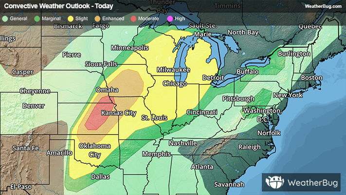
Today
84°FShowers likely and a chance of thunderstorms until late afternoon then a slight chance of showers and thunderstorms late. Breezy. Highs in the lower 80s. Southwest winds 15 to 20 mph with gusts up to 30 mph. Chance of precipitation 70 percent.
Tonight
67°F
Mostly cloudy. A slight chance of showers and thunderstorms early in the evening. A slight chance of showers and thunderstorms after midnight then a chance of showers and thunderstorms late. Breezy with lows in the mid 60s. South winds 10 to 15 mph increasing to 15 to 20 mph after midnight. Gusts up to 30 mph. Chance of precipitation 40 percent.
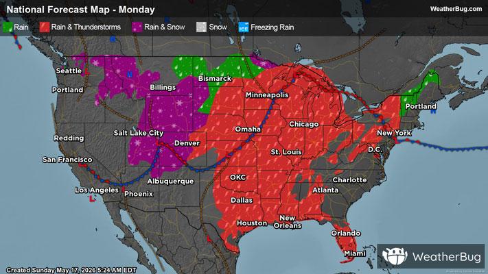
- 81|54°F70% Chance of StormsHourly details
Day
81°FShowers likely with a chance of thunderstorms. Breezy with highs in the lower 80s. Southwest winds 15 to 20 mph becoming west in the afternoon. Gusts up to 30 mph. Chance of precipitation 70 percent.
Night
54°F
Mostly cloudy. A slight chance of showers and thunderstorms in the evening. Lows around 50. Northwest winds 10 to 15 mph. Chance of precipitation 20 percent.
- 64|45°F
 Partly CloudyHourly details
Day
64°FMostly cloudy in the morning then becoming partly cloudy. Highs in the lower 60s. Northeast winds 10 to 15 mph.
Night
45°F
Mostly cloudy in the evening then becoming partly cloudy. Lows in the lower 40s.
- 68|51°FPartly CloudyHourly details
Day
68°FMostly sunny in the morning then becoming partly cloudy. Highs in the upper 60s.
Night
51°FPartly cloudy in the evening then becoming mostly cloudy. Lows in the upper 40s.
- 68|52°F
 40% Chance Rain ShowersHourly details
Day
68°FMostly cloudy with a chance of showers. Highs in the lower 70s. Chance of precipitation 40 percent.
Night
52°F
Mostly cloudy. A chance of showers after midnight. Lows in the lower 50s. Chance of precipitation 30 percent.
Weekend Weather
- 76|54°F
 Mostly CloudyHourly details
Day
76°FMostly cloudy. Highs in the upper 70s.
Night
54°FMostly cloudy in the evening then becoming partly cloudy. Lows in the mid 50s.
- 77|61°FPartly Cloudy
Day
77°FPartly cloudy. Highs in the lower 80s.
Night
61°F
Partly cloudy with a 35% chance for rain and thunderstorms. Low temperature around 61F. Dew point will be around 61F with an average humidity of 88%. Winds will be 5 mph from the SE.
- 80|64°F
 40% Chance of Rain
Day
80°FMostly cloudy with a chance of rain. Chance of precipitation 35%. High temperature around 80F. Dew point will be around 65F with an average humidity of 70%. Winds will be 6 mph from the S.
Night
64°FPartly cloudy with a chance of rain. Chance of precipitation 35%. Low temperature around 64F. Dew point will be around 63F with an average humidity of 87%. Winds will be 5 mph from the S.
- 81|63°F30% Chance of Rain
Day
81°FPartly cloudy with a slight chance of rain. Chance of precipitation 30%. High temperature around 81F. Dew point will be around 65F with an average humidity of 68%. Winds will be 3 mph from the SW.
Night
63°FPartly cloudy with a slight chance of rain. Chance of precipitation 30%. Low temperature around 63F. Dew point will be around 61F with an average humidity of 81%. Winds will be 2 mph from the S.
- 83|64°F40% Chance of Rain
Day
83°FMostly sunny with a chance of rain. Chance of precipitation 35%. High temperature around 83F. Dew point will be around 64F with an average humidity of 63%. Winds will be 3 mph from the SW.
Night
64°FPartly cloudy with a chance of rain. Chance of precipitation 35%. Low temperature around 64F. Dew point will be around 62F with an average humidity of 79%. Winds will be 2 mph from the S.