10-Day Weather Forecast - Craigmont, ID
Weekend Weather
- 52|44°F
 30% Chance Rain ShowersHourly details
Today
52°FMostly cloudy. A chance of rain showers in the morning. Highs in the mid 50s to mid 60s. Chance of precipitation 30 percent. Rainfall amounts less than a tenth of an inch.
Tonight
44°F
Mostly cloudy. Lows in the upper 30s to mid 40s.
- 58|44°F
 Partly CloudyHourly details
Day
58°FMostly cloudy in the morning becoming partly cloudy. Warmer. Highs in the 60s.
Night
44°F
Partly cloudy. Lows in the 40s.
- 66|47°FPartly CloudyHourly details
Day
66°FPartly cloudy. Warmer. Highs in the mid 60s to lower 70s.
Night
47°FPartly cloudy. Lows in the lower 40s to lower 50s. Highs in the upper 60s to upper 70s.
- 69|48°FPartly CloudyHourly details
Day
69°FPartly cloudy. Lows in the lower 40s to lower 50s. Highs in the upper 60s to upper 70s.
Night
48°FPartly cloudy. Lows in the lower 40s to lower 50s. Highs in the upper 60s to upper 70s.
- 73|54°FPartly CloudyHourly details
Day
73°FPartly cloudy. Lows in the lower 40s to lower 50s. Highs in the upper 60s to upper 70s.
Night
54°F
Mostly cloudy with a chance of showers and thunderstorms. Lows in the mid 40s to lower 50s. Chance of precipitation 50 percent.
- 65|48°FPartly CloudyHourly details
Day
65°FPartly cloudy with a 20 percent chance of rain showers. Highs in the mid 60s to lower 70s.
Night
48°F
Mostly clear. Lows in the mid 40s to lower 50s. Highs in the 70s.
- 73|52°F
 Mostly Sunny
Day
73°FMostly clear. Lows in the mid 40s to lower 50s. Highs in the 70s.
Night
52°FPartly cloudy. Low temperature around 52F. Dew point will be around 50F with an average humidity of 64%. Winds will be 5 mph from the NW.
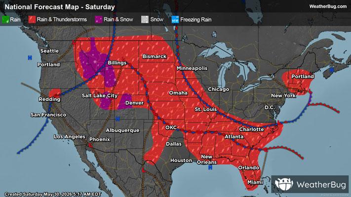
Weekend Weather
- 64|46°F
 30% Chance of Rain
Day
64°FPartly cloudy with a slight chance of rain. Chance of precipitation 25%. High temperature around 64F. Dew point will be around 48F with an average humidity of 62%. Winds will be 5 mph from the N.
Night
46°F
Mostly clear with a slight chance of rain. Chance of precipitation 25%. Low temperature around 46F. Dew point will be around 41F with an average humidity of 68%. Winds will be 3 mph from the NW.
- 62|46°F30% Chance of Rain
Day
62°FPartly cloudy with a slight chance of rain. Chance of precipitation 25%. High temperature around 62F. Dew point will be around 43F with an average humidity of 58%. Winds will be 4 mph from the N.
Night
46°FPartly cloudy. Low temperature around 46F. Dew point will be around 40F with an average humidity of 66%. Winds will be 3 mph from the NW.
- 67|49°F
 Mostly Cloudy
Day
67°FMostly cloudy. High temperature around 67F. Dew point will be around 45F with an average humidity of 54%. Winds will be 4 mph from the N.
Night
49°FPartly cloudy. Low temperature around 49F. Dew point will be around 43F with an average humidity of 62%. Winds will be 3 mph from the NW.