10-Day Weather Forecast - Ford City, AL
- |26°F40% Chance Frozen MixHourly details
Tonight
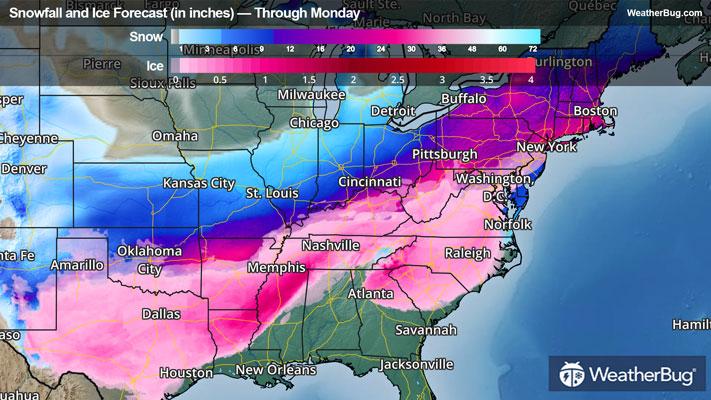
26°FColder. Mostly cloudy. A slight chance of snow showers and sleet after midnight. A chance of sleet freezing rain and snow showers late. Lows in the lower 20s. Northeast winds 10 to 15 mph with gusts to around 30 mph. Chance of precipitation 40 percent.
Weekend Weather
- 32|32°FFrozen MixHourly details
Day
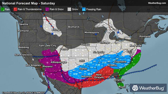
32°FCooler. Sleet and freezing rain likely in the morning then freezing rain and showers with sleet likely in the afternoon. Precipitation may be heavy at times in the afternoon. Little or no sleet accumulation. Ice accumulation of up to one quarter of an inch. Highs in the mid 30s. Northeast winds 10 to 15 mph. Chance of precipitation 100 percent.
Night
32°FCold showers. Freezing rain in the evening then a slight chance of thunderstorms after midnight. Ice accumulation of up to one quarter of an inch. Lows in the upper 20s. Temperature rising into the in the upper 30s after midnight. Northeast winds around 10 mph. Chance of precipitation 100 percent.
- 38|16°FFrozen MixHourly details
Day
38°FShowers and freezing rain in the morning then showers likely a chance of freezing rain and snow showers in the afternoon. Precipitation may be heavy at times in the morning. Little or no snow accumulation. Ice accumulation of up to one quarter of an inch. Highs 37 to 42. Temperature falling into the in the upper 20s in the afternoon. Northwest winds 10 to 15 mph. Chance of precipitation 100 percent.
Night
16°FMuch colder. Mostly cloudy. A slight chance of snow showers and sleet in the evening. Lows 10 to 15. Northwest winds 10 to 15 mph. Chance of precipitation 20 percent. Wind chill readings zero to 5 above zero.
- 26|8°FPartly CloudyHourly details
Day
26°FMuch colder. Mostly cloudy in the morning then becoming partly cloudy. Highs in the mid 20s.
Night
8°FMostly clear. Lows zero to 5 above zero. Highs in the lower 30s.
- 36|20°FMostly SunnyHourly details
Day
36°FMostly clear. Lows zero to 5 above zero. Highs in the lower 30s.
Night
20°FPartly cloudy. Lows near 15. Highs in the upper 30s.
- 38|19°FPartly CloudyHourly details
Day
38°FPartly cloudy. Lows near 15. Highs in the upper 30s.
Night
19°FPartly cloudy. Lows near 15. Highs in the upper 30s.
- 32|17°FPartly CloudyHourly details
Day
32°FCold. Partly cloudy. Highs in the lower 30s.
Night
17°FCold. Partly cloudy in the evening then becoming mostly cloudy. Lows near 10.
- 35|21°FPartly Cloudy
Day
35°FCold. Partly cloudy. Highs in the lower 30s.
Night
21°FPartly cloudy. Low temperature around 21F. Dew point will be around 17F with an average humidity of 74%. Winds will be 4 mph from the N.
Weekend Weather
- 35|23°FCloudy
Day
35°FCloudy. High temperature around 35F. Dew point will be around 19F with an average humidity of 61%. Winds will be 3 mph from the N.
Night
23°FCloudy. Low temperature around 23F. Dew point will be around 19F with an average humidity of 77%. Winds will be 3 mph from the N.
- 38|24°FMostly Cloudy
Day
38°FMostly cloudy. High temperature around 38F. Dew point will be around 21F with an average humidity of 62%. Winds will be 4 mph from the NW.
Night
24°FPartly cloudy. Low temperature around 24F. Dew point will be around 21F with an average humidity of 76%. Winds will be 4 mph from the NW.