10-Day Weather Forecast - Forest Grove Station, MI
Weekend Weather
- |36°FPartly CloudyHourly details
Tonight
36°FPartly cloudy. Lows in the mid 30s. West winds 5 to 15 mph with gusts to around 25 mph.
- 46|28°FMostly SunnyHourly details
Day
46°FMostly sunny. A 20 percent chance of rain showers in the morning. Highs in the mid 40s. West winds 5 to 15 mph with gusts to around 30 mph.
Night
28°FMostly clear. Lows in the mid 20s. Northwest winds 5 to 10 mph with gusts to around 30 mph in the evening becoming light.
- 47|38°FSunnyHourly details
Day
47°FSunny. Highs in the mid 40s. Light winds becoming west 5 to 10 mph in the afternoon.
Night
38°FPartly cloudy. Lows in the mid 30s. South winds around 10 mph. Gusts up to 25 mph after midnight.
- 67|44°FMostly SunnyHourly details
Day
67°FMostly sunny. Highs in the mid 60s.
Night
44°FPartly cloudy. Lows in the lower 40s.
- 69|52°FSunnyHourly details
Day
69°FSunny. Highs in the upper 60s.
Night
52°FMostly clear. Lows in the upper 40s.
- 80|65°FMostly SunnyHourly details
Day
80°FMostly sunny. Highs in the mid 70s.
Night
65°FPartly cloudy with a 40 percent chance of rain showers. Lows in the upper 50s.
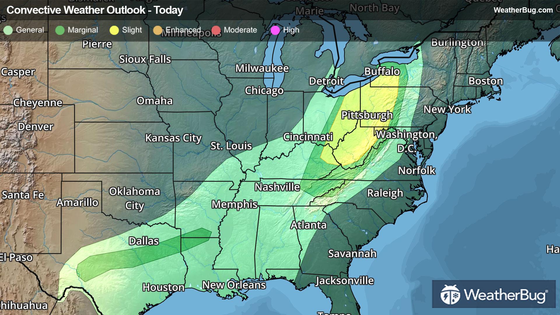
- 73|53°F60% Chance of StormsHourly details
Day
73°FRain showers likely and a slight chance of thunderstorms. Highs in the lower 70s. Chance of rain 60 percent.
Night
53°FRain showers likely and a slight chance of thunderstorms. Lows in the mid 40s. Chance of rain 60 percent.
Weekend Weather
- 61|45°F40% Chance Rain Showers
Day
61°FPartly sunny with a 40 percent chance of rain showers. Highs in the upper 50s.
Night
45°FMostly clear. Low temperature around 45F. Dew point will be around 42F with an average humidity of 71%. Winds will be 4 mph from the NW.
- 59|43°FMostly Sunny
Day
59°FMostly sunny. High temperature around 59F. Dew point will be around 41F with an average humidity of 65%. Winds will be 4 mph from the N.
Night
43°FPartly cloudy. Low temperature around 43F. Dew point will be around 39F with an average humidity of 70%. Winds will be 4 mph from the N.
- 59|44°FMostly Sunny
Day
59°FMostly sunny. High temperature around 59F. Dew point will be around 41F with an average humidity of 66%. Winds will be 4 mph from the NW.
Night
44°FClear. Low temperature around 44F. Dew point will be around 39F with an average humidity of 70%. Winds will be 3 mph from the NW.